
Mississippi embayment facts for kids

The Mississippi Embayment is a special land area in the south-central United States. It's part of the larger Mississippi Alluvial Plain. Think of it as a long arm of the Mississippi River Delta, stretching north until the Mississippi River meets the Ohio River at Cairo, Illinois.
This area is filled with mud, sand, and other materials carried by rivers. It formed a very long time ago, during the Cretaceous period (when dinosaurs lived) and the early Cenozoic era (soon after). Scientists believe it started as a big dip in the land that slowly filled up.
In 2007, scientists Van Arsdale and Cox suggested a reason for its formation. They think that the Earth's crust moved this region over a super-hot spot deep inside the Earth's mantle. This "hotspot" caused hot, melted rock (called magma) to push up. This pushing formed the Appalachian and Ouachita mountain ranges. Later, rain and wind wore down the land, creating a deep valley. This valley was then flooded by the Gulf of Mexico and slowly filled with sediment from the Mississippi River.
Contents
What is the Mississippi Embayment?
The embayment is a low, bowl-shaped area. It's filled with layers of rock and dirt that have built up from the Cretaceous period until today. At its northern end, the embayment looks like a strange gap in the usual rock layers. Very old layered rocks (called Paleozoic sedimentary rocks) are found both to the east in Kentucky and Tennessee, and to the west in Missouri and Arkansas.
This basin, filled with sediment, was once a huge bay. It was part of the coastline during the time of dinosaurs and the early Cenozoic era.
Earthquakes and Ancient Rifts
The New Madrid Seismic Zone is located at the northern end of the embayment. This area was the site of the huge 1811–12 New Madrid earthquakes in 1811 and 1812.
Underneath this area, there are some unusual rock formations. The Reelfoot Rift is like an old, broken crack in the Earth's crust. It's called an aulacogen, which means it's a "failed" rift. This rift formed way back in the Precambrian era, when the supercontinent Rodinia was breaking apart.
Later, the Atlantic Ocean and the Gulf of Mexico started to open up. This happened during the late Paleozoic to early Mesozoic eras, when the supercontinent Pangaea broke apart. These events likely affected the old Reelfoot Rift and might have even made it active again in some ways.
How the Embayment Formed
The Mississippi Embayment marks a break in what was once a single, long mountain range. This range included the modern Appalachian Mountains, which run along the Atlantic coast, and the Ouachita Mountains, which run west of the Mississippi River.
These ancient Appalachian-Ouachita mountains were pushed up about 300 million years ago. This happened when the tectonic plate carrying North America crashed into the plates carrying South America and Africa. All three continents joined together to form the ancient supercontinent Pangaea.
The Hotspot Theory
Around 95 million years ago, Pangaea began to break apart. As North America moved, it passed over a very active volcanic "hotspot" deep in the Earth's mantle. This specific one is called the Bermuda hotspot.
Hot, melted rock (magma) from this hotspot pushed up part of the Appalachian-Ouachita mountain range even higher. It might have lifted the land by 2 to 3 kilometers (about 1.2 to 1.8 miles)! This uplifted land formed an arch shape.
However, this high land quickly wore away due to erosion. As North America moved away from the hotspot and the hotspot's activity slowed down, the Earth's crust beneath the embayment cooled. It then shrank and sank to a depth of about 2.6 kilometers (1.6 miles). This created a deep trough that was flooded by the Gulf of Mexico.
As sea levels dropped, the Mississippi River and other rivers extended their paths into this new embayment. Over time, the embayment gradually filled up with mud, sand, and other sediments carried by these rivers.
Evidence for Formation
Scientists find evidence for this explanation in a few places. There are earthquake zones around New Madrid, Missouri, and Charleston, South Carolina. Both areas had very strong earthquakes in the 1800s. Also, there are diamond-bearing kimberlite pipes in Arkansas. These pipes are formed from volcanic activity, which supports the idea of a hotspot.
Maps
-
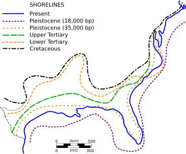
Significant shorelines along the U.S. Gulf and Atlantic Coasts since the Cretaceous Period
-
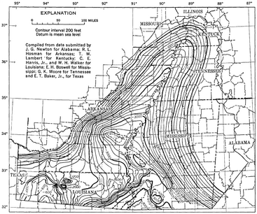
Mississippi Embayment Top Cretaceous Contour Map
-
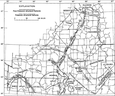
Mississippi Embayment Structural Map


