
Pangaea facts for kids
.png)
Pangaea was a giant supercontinent that existed millions of years ago. It held almost all of Earth's land in one massive piece. This giant landmass formed about 335 million years ago. It stayed together until about 200 million years ago. A single, enormous ocean called Panthalassa surrounded it.
Contents
Who discovered the giant continent Pangaea?


The big idea of Alfred Wegener
In 1912, a scientist named Alfred Wegener had a bold idea. He noticed that the continents looked like puzzle pieces. He suggested they were once joined together. He called this giant landmass "Pangaea."
- The name comes from Greek words meaning "all Earth."
- Wegener used fossils and rocks to prove his theory.
- He called his idea continental drift.
- At first, many other scientists did not believe him.
How the theory became accepted
Wegener could not explain how the continents moved. Later, scientists discovered plate tectonics. This theory explains that Earth's outer shell is broken into plates. These plates float on a hot, liquid layer inside the Earth. This movement is what pushed the continents apart.
What evidence proves Pangaea was real?

Matching fossils across the oceans
Scientists found fossils of the same animals on different continents. For example, the Lystrosaurus lived in Africa, India, and Antarctica. This land animal could not swim across the ocean. This proves these places were once connected.
Ancient mountain ranges and rocks
The Appalachian Mountains in the United States match mountains in Europe. They were once part of the same mountain chain. Scientists also found matching rock layers in South America and Africa. These clues show the continents were once neighbors.
How did the supercontinent form?

Pangaea was not the first supercontinent. Earth has a cycle where landmasses crash together and pull apart. This is called the supercontinent cycle.
- First, smaller continents like Euramerica and Gondwana moved toward each other.
- They crashed together to form the giant "C" shape of Pangaea.
- This collision created massive mountain ranges, some as tall as the Himalayas.
- By the Permian period, almost all land was joined.
Life and nature on the giant landmass


Plants and animals of the era
Life on Pangaea was very different from today. The center of the continent was a huge, dry desert. This was because it was far from the ocean's moisture.
- Early dinosaurs began to roam the land.
- The first true mammals appeared during this time.
- Plants like conifers and ferns covered the ground.
- Insects and early reptiles lived in the vast forests.
The climate of a supercontinent
Because Pangaea was so big, it had extreme weather. The interior was very hot in the summer and cold in the winter. Scientists believe there were massive monsoons (heavy rain seasons). These rains brought water to the edges of the continent.
Why did Pangaea break apart?

Pangaea did not break all at once. It happened in three major steps over millions of years.
About 175 million years ago, a rift formed between North America and Africa. This created the North Atlantic Ocean. This was the first big crack in the supercontinent.
Later, the southern part called Gondwana broke into pieces. This formed the continents of Africa, South America, India, Antarctica, and Australia. India began moving very fast toward Asia.
In the final stage, North America broke away from Europe. This opened the Norwegian Sea. Australia and Antarctica also separated. Antarctica moved to the South Pole and became covered in ice.
Images for kids
-
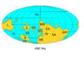
Earth in the late Cambrian, around 490 million years ago.
-
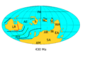
Earth in the middle Silurian, around 430 million years ago.
-
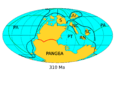
Earth in the late Carboniferous, around 310 million years ago.
-
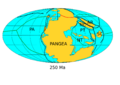
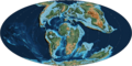
Earth at the start of the Triassic, around 250 million years ago.
-
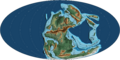
Pangaea during the late Carboniferous period.
-
The Central Pangaean Mountains during the Permian period.
-
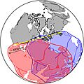
Different ideas about how the continents were shaped.
-
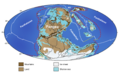
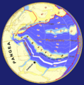
Pangaea and the surrounding oceans.
-
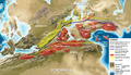
Mountain ranges at the equator of Pangaea.
-
Pangaea at the start of the Triassic period.
-

Pangaea starting to break apart.
-
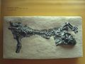
Fossil of a Lystrosaurus found in South Africa.
-

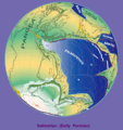
The opening of the North Atlantic Ocean.
-

Earth during the Early Cretaceous period.
-
Earth during the Late Cretaceous period.
-

Earth during the Early Cenozoic era.
-

Earth around 30 million years ago.


.png)

.png)

.png)
.png)
.png)
.png)
.png)
See also
 In Spanish: Pangea para niños
