
Gondwana facts for kids

Gondwana, also known as Gondwanaland, was a huge southern supercontinent. It formed when an even bigger supercontinent called Pangaea started to break apart. This happened about 180 million years ago (mya), during the early Jurassic period.
Pangaea was fully formed around 250 million years ago. Then, it split into two large supercontinents. The northern part was called Laurasia, and the southern part became Gondwana. Over a very long time, Gondwana slowly moved south, while Laurasia drifted north.
Gondwana included most of the land we see today in the Southern Hemisphere. This included Antarctica, South America, Africa, Madagascar, Australia (with New Guinea), and New Zealand. It also contained Arabia and the Indian subcontinent, which have since moved into the Northern Hemisphere. Gondwana itself began to break up about 170 million years ago.
Contents
How Gondwana Got Its Name

An Austrian scientist named Eduard Suess gave Gondwana its name. He chose the name after the Gondwana region in India. This is because some of the oldest rocks from this ancient continent were first studied there. The name "Gondwana" comes from the Sanskrit word "gondavana," which means "forest of the Gonds." The Gondi people are a group who live in that part of India.
The word Gondwanan is often used in biogeography. This is the study of where different organisms live. It describes plants and animals that are found in two or more of the separate land areas that were once part of Gondwana. For example, the Proteaceae is a plant family that grows only in southern South America, South Africa, and Australia. This is called a "Gondwanan distribution." It shows that these plants have been around for a very long time, since Gondwana existed.
The way plants and animals are spread across the world helped scientists like Alfred Russel Wallace and Alfred Wegener with their ideas. Wallace used it to explain evolution. Wegener used it as proof for his idea of continental drift.
How Gondwana Broke Apart
Gondwana broke into many pieces between 160 and 23 million years ago. Africa separated from Antarctica around 160 million years ago. Then, Africa separated from the Indian subcontinent about 125 million years ago, in the early Cretaceous period.
About 65 million years ago, Antarctica was still connected to Australia. It had a warm, tropical climate and was home to marsupial animals. Around 40 million years ago, Australia and New Guinea finally separated from Antarctica. This allowed cold ocean currents to flow around Antarctica, and ice began to form there.
During a big extinction event about 34 million years ago, the amount of carbon dioxide in the air was much lower than before. This change in climate played a big role in what happened next.
Around 23 million years ago, the Drake Passage opened up between Antarctica and South America. This created the Antarctic Circumpolar Current, which completely isolated Antarctica. This made the continent much colder. The ice started to spread, replacing the forests that once covered Antarctica. Since about 15 million years ago, Antarctica has been mostly covered with ice. Around six million years ago, the Antarctic ice cap reached its current size.
Lands Now Underwater
There are several lands now submerged (underwater) in the Indian Ocean, west of Australia. They are buried under more than 1.5 kilometers (0.93 miles) of water. The rocks found there show that these lands were once part of Gondwana. They are not the usual rocks found in the ocean, like basalt. Instead, they are land rocks, like granite, sandstone, and gneiss. They also contain fossils that are usually found on continents.
Recently, two of these sunken islands were found west of Perth, Western Australia. These islands are almost as big as Tasmania and have flat tops. This means they were once at sea level before sinking. It also shows that they were the last link between India and Australasia when India started to break away in the early Cretaceous period.
Naturaliste Plateau
The Naturaliste Plateau is a submerged land area off the coast of Western Australia. It covers about 90,000 square kilometres (34,749 square miles).
This plateau might have large amounts of oil. When it was above water during the Mesozoic era, it had a tropical climate. This climate would have been perfect for creating coal, oil, and natural gas deposits.
Kerguelen Microcontinent
The Kerguelen Plateau is a submerged microcontinent in the southern Indian Ocean. It is about 3,000 kilometers (1,864 miles) southwest of Australia. It stretches for more than 2,200 kilometers (1,367 miles) from northwest to southeast. Most of it is under deep water. However, a small part of the plateau is above sea level. This forms the Australian Heard Island and McDonald Islands and the French Kerguelen Islands. These islands are part of a huge area of volcanic rock that formed when Gondwana began to break up, starting 130 million years ago.
Sometimes, volcanic activity still happens on Heard and McDonald islands.
Images for kids
-
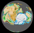
Gondwana 420 million years ago (late Silurian period). This view is centered on the South Pole.
-
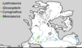
Distribution of four fossil groups from the Permian and Triassic periods. These fossils helped prove continental drift.
-
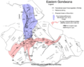
Eastern Gondwana. The blue areas show where the East African Orogeny extended (620-550 million years ago). The red areas show where the Kuunga orogeny caused changes in rocks (570-530 million years ago).
-
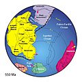
A map showing the final stages of Gondwana coming together, 550 million years ago.
-
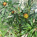
Banksia, a type of Proteaceae plant, is an example of a plant family found in areas that were once part of Gondwana.


See also
 In Spanish: Gondwana para niños
