
Sea level facts for kids


- Ocean
- Reference ellipsoid
- Local plumb line
- Continent
- Geoid


.jpg)
Sea level is basically the average height of the ocean's surface. It's used as a starting point, like a zero line, to measure how high mountains are or how low valleys are.
Imagine the ocean surface. It's not perfectly flat, right? Waves are crashing, tides are going in and out, and currents are flowing. So, how do scientists figure out a single "level" for the sea?
They use something called Mean Sea Level (MSL). Think of "mean" like "average." Mean Sea Level is the average height of the ocean's surface over a long period of time, like many years. This helps smooth out all the temporary ups and downs caused by waves, tides, and weather.
Why is this average height important? Well, it acts like a giant, worldwide ruler! When you see the height of a mountain on a map, like "Mount Everest: 8,848 meters," that height is measured from Mean Sea Level. This is called Height Above Mean Sea Level (AMSL). Even places below sea level, like Death Valley in California, have their height measured this way, but it's a negative number!
Sailors and mapmakers use sea level as a reference point for charts and navigation. It helps them know how deep the water is or how high the land is near the coast.
Pilots also use sea level as a reference. When they are flying, their instruments (called altimeters) can be set to show their height above sea level. This helps them know how high they are above the ground, especially when landing or flying over mountains.
Contents
How Do We Measure Sea Level?
Measuring the average height of the ocean isn't as simple as dipping a ruler in the water! Because the ocean is always moving, scientists use special tools and methods:
- Tide Gauges: These are instruments placed along coastlines. They continuously measure the height of the water. To find the Mean Sea Level for that specific location, scientists average the readings from the tide gauge over a very long time, sometimes even 19 years! This long average helps cancel out the effects of daily tides and seasonal changes. Different countries and regions use Mean Sea Level measured at specific, historical locations as their official reference point. For example, in the UK, the reference height (called the ordnance datum) was set using measurements from Newlyn in Cornwall between 1915 and 1921. In France, the Marégraphe in Marseilles has been measuring sea level since 1883 and is used as a reference for parts of Europe and Africa.
- Satellites: Since the 1990s, satellites orbiting Earth have become super important for measuring sea level across the entire globe. Satellites like TOPEX/Poseidon (launched in 1992) and the Jason missions (like Jason-1 in 2001 and Jason-2 in 2008) use special tools called altimeters. These altimeters send radar pulses down to the ocean surface and measure how long it takes for the pulse to bounce back. This tells the satellite the height of the sea surface very accurately. By combining data from many satellite passes over time, scientists can calculate the global Mean Sea Level and see how it's changing. Satellite measurements continue today, giving us a constant watch on the ocean's height from space.
Measuring sea level precisely is tricky because many things affect the water's height at any given moment, like:
- Tides: The pull of the Moon and Sun causes the water level to rise and fall throughout the day.
- Wind: Wind can push water around, piling it up in some places and lowering it in others.
- Atmospheric Pressure: Changes in air pressure can slightly affect the water level.
- Temperature and Salinity: Warmer water expands, and saltier water is denser. These differences can cause slight variations in the height of the water.
- Local Gravity: Believe it or not, tiny differences in Earth's gravity in different places can also affect the shape of the ocean surface!
By averaging measurements over long periods, scientists can get past these temporary changes and find the true average level.
Local vs. Global Sea Level
When we talk about sea level changing, it can mean two slightly different things:
- Local Mean Sea Level (LMSL): This is the average sea level at a specific location on the coast, measured relative to the land right there. The land itself can sometimes move up or down very slowly. For example, areas that were covered by heavy ice sheets thousands of years ago are still slowly rising now that the ice is gone (this is called isostatic adjustment). If the land is sinking, the local sea level will appear to rise faster, even if the amount of water in the ocean hasn't changed much globally. If the land is rising, the local sea level might appear to rise slower or even fall.
- Eustatic Sea Level Change: This refers to the global change in the total amount of water in the oceans or the size of the ocean basins. This is what most people mean when they talk about "sea level rise" on a global scale.
Why Does Global Sea Level Change?
Global sea level isn't always the same; it can change over very long periods. Currently, scientists are observing that global sea level is rising. The two main reasons for this are:
- Melting Ice: Large amounts of ice stored on land, like glaciers in the mountains and the big ice sheets in Greenland and Antarctica, are melting. When this ice melts, the water flows into the ocean, adding more water and causing the sea level to rise.
- Thermal Expansion: As the ocean water gets warmer, it expands slightly, just like most things do when they heat up. Since the oceans are huge, even a small amount of expansion from warming water adds up to a significant increase in the total volume of water, causing the sea level to rise.
Images for kids
-
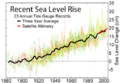
Sea level measurements from 23 long tide gauge records in geologically stable environments show a rise of around 200 millimetres (7.9 in) during the 20th century (2 mm/year).

See also
 In Spanish: Nivel del mar para niños
