Last Glacial Period facts for kids
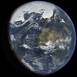
The Last Glacial Period, often called the Last Ice Age, was a time when huge ice sheets covered much of the Earth. It happened from about 115,000 to 11,700 years ago. This period is part of a longer series of cold "glacial" times and warmer "interglacial" times, known as the Quaternary glaciation. This larger ice age started about 2.58 million years ago and is still technically ongoing, as ice sheets remain at the poles.
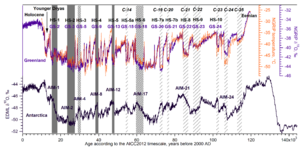
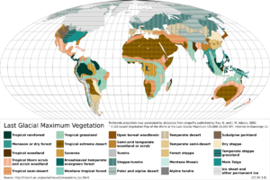
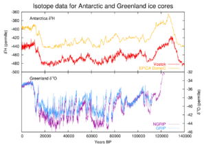
During the Last Glacial Period, glaciers grew and shrank many times. The coldest part, called the Last Glacial Maximum, was about 22,000 years ago. Around 12,800 years ago, there was a final cold snap called the Younger Dryas. When it ended about 11,550 years ago, our current warmer period, the Holocene, began.
For humans, this ice age happened during the Paleolithic (Old Stone Age) and early Mesolithic (Middle Stone Age). Early humans, Homo sapiens, lived in warmer areas. They used tools similar to those of Neanderthals in Europe and Asia. Scientists believe humans survived the ice age in areas with some trees and plenty of food, avoiding thick forests.
Contents
What is the Last Ice Age?
People often call the Last Glacial Period the "last ice age." But the term "ice age" can be confusing. Geologists use "ice age" for a long time when there's ice at both poles, which is still true today! A "glacial" period is a colder time within an ice age when glaciers grow. A warmer time between glacials is called an "interglacial."
The Last Glacial Period ended about 10,000 years ago. But large ice sheets still exist in Antarctica and Greenland. Over millions of years, these glacial and interglacial cycles have been caused by small changes in Earth's orbit around the Sun. These are called Milankovitch cycles.
Scientists have studied this ice age a lot in North America, Europe, the Himalayas, and other places that used to be covered by ice. The ice sheets had different names in different regions:
- Fraser in North America's Pacific mountains
- Wisconsinan in central North America
- Devensian in the British Isles
- Würm in the Alps
- Weichselian in Northern Europe
- Llanquihue in Chile
- Otira in New Zealand
Ice Across the World
Northern Hemisphere Ice Sheets
Canada and the northern United States were almost completely covered by the huge Laurentide Ice Sheet. Alaska mostly stayed ice-free because it was very dry. The Rocky Mountains and Sierra Nevada also had their own large glaciers.
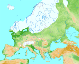
In northern Europe, the Scandinavian ice sheet reached parts of the British Isles, Germany, Poland, and Russia. It stretched all the way to Siberia. The Arctic Ocean between these giant ice sheets wasn't completely frozen. It likely had thinner ice, like today, with icebergs breaking off from the surrounding glaciers.
Beyond the main ice sheets, many high mountains had glaciers. This included the Pyrenees, Carpathian Mountains, Caucasus, and mountains in Turkey and Iran. In the Himalayas and Tibetan Plateau, glaciers grew a lot between 47,000 and 27,000 years ago.
Even in warmer areas, some mountains had glaciers. Parts of Taiwan and the Japanese Alps were covered by ice at times. In Africa, small glaciers existed on mountains like Mount Kilimanjaro and Mount Kenya, which still have small glaciers today.
Southern Hemisphere Ice Sheets
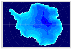
The Southern Hemisphere had less ice. Large ice sheets covered the Andes mountains in South America. Antarctica was completely covered in ice, even more so than today.
In Australia, only a tiny area around Mount Kosciuszko had ice. But in Tasmania and New Zealand, glaciers were much larger. The highest mountains of New Guinea also had ice caps, where temperatures were much colder than they are now. Some of these glaciers still exist today on peaks like Puncak Jaya.
Small glaciers also formed in a few places in Southern Africa, especially in the Lesotho Highlands. These areas were about 6°C colder than they are today.
How the Ice Age Ended
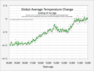
As the ice sheets melted, the Earth's climate changed. Scientists found over a hundred huge craters in the ocean floor near the Barents Sea. These craters were formed by explosive eruptions of methane gas from under the seabed. This happened as the ice sheets retreated about 12,000 years ago. The melting ice removed pressure, causing the trapped methane to escape. These areas still leak methane today.
Ice Age Names Around the World
Europe's Ice Ages
Devensian and Midlandian Glaciation (Britain and Ireland)
In Britain, this ice age is called the Devensian. In Ireland, it's known as the Midlandian glaciation. The name Devensian comes from the River Dee in Wales, where deposits from this period are found.
You can see the effects of this ice age in many geological features across England, Wales, Scotland, and Northern Ireland. The deposits from this time are found above older layers and below the layers from our current period, the Holocene.
This ice age is called the Weichselian in Scandinavia and northern Europe. The ice sheets were at their biggest for a short time, between 25,000 and 13,000 years ago. During this peak, only parts of Denmark were ice-free. A large area of what is now the North Sea was dry land, connecting Denmark with Britain. This land is called Doggerland.
The Baltic Sea, which has unique salty water, was formed by meltwater from the Weichselian ice sheet mixing with saltwater from the North Sea. As the ice melted, the land that had been pressed down by the ice started to rise. This is still happening today in Scandinavia, with the land rising by up to 8–9 mm each year. This is important for archaeologists, as ancient coastal sites are now found inland.
Würm Glaciation (Alps)
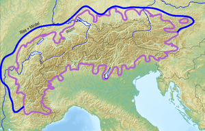
The Würm glaciation is named after a river in the Alps. This region was where scientists first studied ice ages in detail. During the coldest part of the Würm glaciation, about 24,000 to 10,000 years ago, most of Europe was open grassland and tundra. The Alps themselves were covered in solid ice fields and mountain glaciers.
The huge Rhône Glacier covered much of western Switzerland. The Rhine Glacier also grew very large. These glaciers shaped the land by grinding away rocks, leaving behind hills of debris called moraines, and changing river paths.
North America's Ice Ages
Pinedale or Fraser Glaciation (Rocky Mountains)
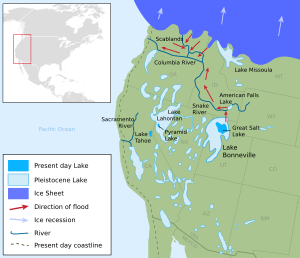
The Pinedale (in the central Rocky Mountains) or Fraser (in the Cordilleran ice sheet) glaciation was the last major ice advance in the Rocky Mountains. It lasted from about 30,000 to 10,000 years ago. This glaciation was different from the main ice sheets because it was made up of mountain glaciers that joined together.
The Cordilleran ice sheet created features like glacial Lake Missoula. This huge lake would burst through its ice dam, causing massive floods known as the Missoula Floods. Geologists think these floods happened about 40 times over 2,000 years, starting 15,000 years ago.
Wisconsin Glaciation
The Wisconsin glacial episode was the last big advance of the giant Laurentide Ice Sheet in North America. When the ice was at its peak, the Bering land bridge connected Siberia to North America. This allowed animals, and possibly early humans, to cross into North America.
This ice sheet completely changed the geography of North America north of the Ohio River. Ice covered most of Canada, the upper Midwest, and New England. You can still see the deep grooves left by these glaciers on rocks in places like Kelleys Island or New York's Central Park.
The Great Lakes were formed by the glaciers scraping out huge basins and then filling with meltwater as the ice retreated. The enormous weight of the ice also pushed the land down. As the ice melted, the land slowly started to rise again. Niagara Falls and the path of the Ohio River were also created by this glaciation.
As the Wisconsin ice sheet melted, it left behind piles of rock and dirt called terminal moraines. These moraines formed places like Long Island, Cape Cod, and Martha's Vineyard.
Sierra Nevada Glaciation (Tahoe, Tenaya, and Tioga)
In the Sierra Nevada mountains, there were three main periods when glaciers grew, called Tahoe, Tenaya, and Tioga. The Tahoe was the oldest, reaching its biggest size about 70,000 years ago. The Tioga was the last and least severe. It started about 30,000 years ago, was biggest 21,000 years ago, and ended about 10,000 years ago.
Greenland Glaciation
In northwest Greenland, the ice reached its biggest size very early in the Last Glacial Period, around 114,000 years ago. After that, the ice cover was similar to today until the very end of the ice age. Ice core data shows that Greenland was very dry during this time, with much less snow than today.
South America's Ice Ages
Mérida Glaciation (Venezuelan Andes)
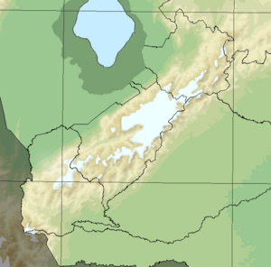
The Mérida glaciation refers to the mountain glaciers in the central Venezuelan Andes. During this time, the snow line was about 1,200 meters lower than it is today. The glaciated area was about 600 square kilometers. Most of the glaciers were in the Sierra Nevada de Mérida. Evidence suggests these glaciers are older than 10,000 years.
Llanquihue Glaciation (Southern Andes)
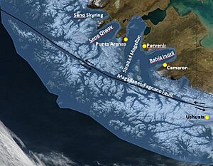
The Llanquihue glaciation is named after Llanquihue Lake in southern Chile. During the Last Glacial Maximum, the Patagonian ice sheet covered the Andes mountains from about 35°S down to Tierra del Fuego at 55°S. The western part of the ice sheet was very active, while the eastern part was colder and less active.
Areas west of Llanquihue Lake were ice-free during this time. They had scattered trees, mostly Nothofagus. The dense Valdivian temperate rain forest was much smaller and found only in small patches on the western side of the Andes.
See also
 In Spanish: Glaciación Würm (Edad de Hielo) para niños
| Region | Glacial 1 | Glacial 2 | Glacial 3 | Glacial 4 |
|---|---|---|---|---|
| Alps | Günz | Mindel | Riss | Würm |
| North Europe | Eburonian | Elsterian | Saalian | Weichselian |
| British Isles | Beestonian | Anglian | Wolstonian | Devensian |
| Midwest U.S. | Nebraskan | Kansan | Illinoian | Wisconsinan |
- Glacial history of Minnesota
- Glacial lake outburst flood
- Glacial period
- Penultimate Glacial Period
- Pleistocene, which includes:
- Pleistocene megafauna
- Plio-Pleistocene
- Quaternary extinction event
- Quaternary glaciation
- Sea level rise
- Stone Age
- Timeline of glaciation
- Valparaiso Moraine
 | William L. Dawson |
 | W. E. B. Du Bois |
 | Harry Belafonte |


