
Tibetan Plateau facts for kids


The Tibetan Plateau is a huge, high flat area of land in Central Asia. It is also called the Qinghai-Tibetan Plateau. This amazing place covers most of the Tibet Autonomous Region and Qinghai Province in China. It also reaches into Ladakh in Kashmir, India.
This plateau is enormous, stretching about 1,000 kilometers (620 miles) wide and 2,500 kilometers (1,550 miles) long. It sits very high up, with an average height of over 4,500 meters (14,800 feet) above sea level. This makes it the highest and largest plateau on Earth!
The Tibetan Plateau was formed by the same powerful forces that created the Himalayas. This happened when the Indian land plate slowly crashed into Asia. This massive collision pushed the land upwards, creating both the towering mountains and the high plateau. The plateau also has a big impact on the world's climate. It is the main reason for the strong monsoon rains that happen in parts of Asia.
Images for kids
-
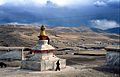
Buddhist stupa and houses outside the town of Aba, on the Tibetan Plateau.
-
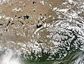
NASA satellite image of the south-eastern area of Tibetan Plateau. Brahmaputra River is in the lower right.
-
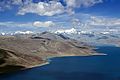
Yamdrok tso is one of the three largest sacred lakes in Tibet.
-
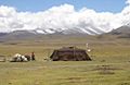
Pastoral nomads camping near Namtso.
-
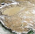
Natural-colour satellite image of the Tibetan Plateau


See also
 In Spanish: Meseta tibetana para niños
