
Qinghai facts for kids
Quick facts for kids
Qinghai
青海
|
|
|---|---|
| Province of Qinghai | |
| Name transcription(s) | |
| • Chinese | 青海省 (Qīnghǎi Shěng) |
| • Abbreviation | QH / 青 (pinyin: Qīng) |
  _-_2024.jpg)  
|
|
.svg)
Map showing the location of Qinghai Province
|
|
| Country | China |
| Named for | Derived from the name of Qinghai Lake ("blue/green lake"). |
| Capital (and largest city) |
Xining |
| Divisions - Prefecture-level - County-level - Township- level |
8 prefectures 44 counties 404 towns and subdistricts |
| Government | |
| • Body | Qinghai Provincial People's Congress |
| Area | |
| • Total | 720,000 km2 (280,000 sq mi) |
| Area rank | 4th |
| Highest elevation
(Bukadaban Feng)
|
6,860 m (22,510 ft) |
| Population
(2020)
|
|
| • Total | 5,923,957 |
| • Rank | 31st |
| • Density | 8.23/km2 (21.31/sq mi) |
| • Density rank | 30th |
| Demographics | |
| • Ethnic composition | Han – 54% Tibetan – 21% Hui – 16% Tu – 4% Mongol – 1.8% Salar – 1.8% |
| • Languages and dialects | Zhongyuan Mandarin Chinese, Amdo Tibetan, Monguor, Oirat Mongolian, Salar and Western Yugur |
| GDP | |
| • Total | CN¥ 379,906 million (30th) US$ 53,913 million |
| • Per capita | CN¥ 63,903 (24th) US$ 9,069 |
| ISO 3166 code | CN-QH |
| HDI (2022) | 0.719 (30th) – high |
| Qinghai | |||||||||||||||||||||||||||||||||||
|---|---|---|---|---|---|---|---|---|---|---|---|---|---|---|---|---|---|---|---|---|---|---|---|---|---|---|---|---|---|---|---|---|---|---|---|
.svg)
"Qinghai" in Chinese characters
|
|||||||||||||||||||||||||||||||||||
| Chinese name | |||||||||||||||||||||||||||||||||||
| Chinese | 青海 | ||||||||||||||||||||||||||||||||||
| Postal | Tsinghai | ||||||||||||||||||||||||||||||||||
| Literal meaning | "Qinghai (Lake)" | ||||||||||||||||||||||||||||||||||
|
|||||||||||||||||||||||||||||||||||
| Tibetan name | |||||||||||||||||||||||||||||||||||
| Tibetan | མཚོ་སྔོན། | ||||||||||||||||||||||||||||||||||
|
|||||||||||||||||||||||||||||||||||
| Mongolian name | |||||||||||||||||||||||||||||||||||
| Mongolian Cyrillic | Хөхнуур | ||||||||||||||||||||||||||||||||||
| Mongolian script | ᠬᠥᠬᠡ ᠨᠠᠭᠤᠷ |
||||||||||||||||||||||||||||||||||
|
|||||||||||||||||||||||||||||||||||
| Manchu name | |||||||||||||||||||||||||||||||||||
| Manchu script | ᡥᡠᡥᡠ ᠨᠣᠣᡵ |
||||||||||||||||||||||||||||||||||
| Romanization | Huhu Noor | ||||||||||||||||||||||||||||||||||
| Oirat name | |||||||||||||||||||||||||||||||||||
| Oirat | Kokonur | ||||||||||||||||||||||||||||||||||
Qinghai is a large province in Northwestern China. It is one of China's biggest provinces by land area, but it has one of the smallest populations. The capital and largest city is Xining.
Qinghai shares borders with Gansu to the northeast, Xinjiang to the northwest, Sichuan to the southeast, and the Tibet Autonomous Region to the southwest. The province was officially created in 1928. Its name, "Qinghai," comes from Qinghai Lake, which is the largest lake in China. This lake is also known as Tso ngon in Tibetan and Kokonor Lake, from a Mongol name.
Most of Qinghai is located on the high Tibetan Plateau. Many different groups of people live here, including the Han, Tibetans, Hui, Mongols, Monguors, and Salars. About half of Qinghai's population belongs to ethnic minority groups.
Contents
History of Qinghai Province
Early History and Ancient Kingdoms
Around 2,000 years ago, during the Bronze Age, Qinghai was home to many different nomadic tribes. These groups were skilled in farming and raising animals. The eastern part of Qinghai was controlled by the Han dynasty at that time.
Later, in the 3rd century CE, nomadic people called the Xianbei moved to the grasslands near Qinghai Lake. They formed a kingdom known as the Tuyuhun Kingdom.
In the 7th century, the Tuyuhun Kingdom faced attacks from both the Tibetan Empire and the Tang dynasty. Both empires wanted to control the important Silk Road trade routes that passed through the region. The Tibetan King Songtsen Gampo won control, and the Tuyuhun Kingdom became part of the Tibetan Empire.
From Mongol Rule to the Qing Dynasty
After the Tibetan Empire weakened, different local groups took control. The Mongol-led Yuan dynasty later ruled the region, calling it Amdo. This area included the sources of the Yellow River and Yangtze River.
Later, a large part of Qinghai came under the control of the Khoshut Khanate, a Mongol group. In 1724, the Qing dynasty armies took over the area. Xining, which is now Qinghai's capital, became an important administrative center.
Qinghai in the 20th Century
After the Qing dynasty fell in 1912, Qinghai was governed by powerful local leaders, including Ma Qi and his family. In 1928, Qinghai officially became a province of China, with Xining as its capital.
In 1932, there was a conflict when Tibet invaded Qinghai, but the local armies in Qinghai successfully defended the province. During the Second Sino-Japanese War and the Chinese Civil War, Qinghai remained relatively peaceful compared to other parts of China.
Local leaders like Ma Bufang started projects to improve the province. They built roads, schools, and hospitals. They also encouraged industries and helped people with farming.
When the Communist Party took control of China in 1949, Qinghai became part of the new People's Republic of China. The province's borders mostly stayed the same.
Geography of Qinghai
Qinghai is located in the northeastern part of the Tibetan Plateau, which is often called the "Roof of the World." It is the largest province in China by land area, not counting the autonomous regions.
Rivers and Lakes
The famous Yellow River starts in the southern part of Qinghai. The Yangtze River and Mekong River also have their sources in the southwestern part of the province.
The Sanjiangyuan National Nature Reserve in Qinghai protects the starting points of these three major rivers. This reserve helps keep the water clean and protects the wildlife.
Qinghai Lake is China's largest saltwater lake. It is also the second-largest saltwater lake in the world. Other big lakes include Lake Hala, Gyaring Lake, and Ngoring Lake. Many salt lakes are found in the western part of the province.
Mountains and Basins
The Riyue Mountain divides Qinghai into two main areas: a western area with grasslands for herding animals and an eastern area with more farming.
The Qaidam Basin is in the northwest of the province. It sits very high up, between 3,000 and 5,000 meters above sea level. About one-third of this basin is desert, but it is rich in natural resources like oil and natural gas.
Climate in Qinghai

Qinghai is very high up, with an average elevation of about 3,000 meters. Because of this high altitude, winters are quite cold, especially in the highest mountains. Summers are mild, and there are big changes in temperature between day and night.
The average yearly temperature is between -5°C and 8°C. January temperatures can be as low as -18°C, while July temperatures are around 15°C to 21°C. The province can also experience strong winds and sandstorms from February to April. Most rain falls in the summer, but overall, the province is quite dry.
Politics and Government
Like other parts of mainland China, Qinghai Province has a one-party government system. The highest-ranking official in the government is the Governor of Qinghai. However, the most powerful person in the province is the Chinese Communist Party Committee Secretary.
Administrative Divisions
Qinghai is divided into eight main areas called prefecture-level divisions. These include two prefecture-level cities and six autonomous prefectures.
Even though Han Chinese are the largest group, Qinghai has many ethnic minorities. Because no single minority group is much larger than the others, the province is not an "autonomous region." Instead, it has many smaller autonomous areas for different ethnic groups at the district and county levels.
| Administrative divisions of Qinghai | ||||||||
|---|---|---|---|---|---|---|---|---|

Xining
Haidong
Haibei
Tibetan AP Huangnan
Tibetan AP Hainan
Tibetan AP Guoluo (Golog)
Tibetan AP Yushu
Tibetan AP Haixi
Mongol and Tibetan AP (Haixi)
|
||||||||
| Division code | Division | Area in km2 | Population 2010 | Seat | Divisions | |||
| Districts | Counties | Aut. counties | CL cities | |||||
| 630000 | Qinghai Province | 720,000.00 | 5,626,723 | Xining city | 7 | 25 | 7 | 5 |
| 630100 | Xining city | 7,424.11 | 2,208,708 | Chengzhong District | 5 | 1 | 1 | |
| 630200 | Haidong city | 13,043.99 | 1,396,845 | Ledu District | 2 | 4 | ||
| 632200 | Haibei Tibetan Autonomous Prefecture | 33,349.99 | 273,304 | Haiyan County | 3 | 1 | ||
| 632300 | Huangnan Tibetan Autonomous Prefecture | 17,908.89 | 256,716 | Tongren city | 2 | 1 | 1 | |
| 632500 | Hainan Tibetan Autonomous Prefecture | 43,377.11 | 441,691 | Gonghe County | 5 | |||
| 632600 | Golog Tibetan Autonomous Prefecture | 76,442.38 | 181,682 | Maqên County | 6 | |||
| 632700 | Yushu Tibetan Autonomous Prefecture | 197,953.70 | 378,439 | Yushu city | 5 | 1 | ||
| 632800 | Haixi Mongol and Tibetan Autonomous Prefecture | 300,854.48 | 489,338 | Delingha city | 3 | 3 | ||
| Administrative divisions in Chinese and varieties of romanizations | ||||
|---|---|---|---|---|
| English | Chinese | Pinyin | ||
| Qinghai Province | 青海省 | Qīnghǎi Shěng | ||
| Xining city | 西宁市 | Xīníng Shì | ||
| Haidong city | 海东市 | Hǎidōng Shì | ||
| Haibei Tibetan Autonomous Prefecture | 海北藏族自治州 | Hǎiběi Zàngzú Zìzhìzhōu | ||
| Huangnan Tibetan Autonomous Prefecture | 黄南藏族自治州 | Huángnán Zàngzú Zìzhìzhōu | ||
| Hainan Tibetan Autonomous Prefecture | 海南藏族自治州 | Hǎinán Zàngzú Zìzhìzhōu | ||
| Golog Tibetan Autonomous Prefecture | 果洛藏族自治州 | Guǒluò Zàngzú Zìzhìzhōu | ||
| Yushu Tibetan Autonomous Prefecture | 玉树藏族自治州 | Yùshù Zàngzú Zìzhìzhōu | ||
| Haixi Mongol and Tibetan Autonomous Prefecture | 海西蒙古族藏族自治州 | Hǎixī Měnggǔzú Zàngzú Zìzhìzhōu | ||
Qinghai's eight prefecture-level divisions are further divided into 44 smaller areas. These include 6 districts, 4 county-level cities, 27 counties, and 7 autonomous counties.
Major Urban Areas
| Population by urban areas of prefecture & county cities | ||||
|---|---|---|---|---|
| # | Cities | 2020 Urban area | 2010 Urban area | 2020 City proper |
| 1 | Xining | 1,677,177 | 1,153,417 | 2,467,965 |
| 2 | Haidong | 204,784 | bgcolor="lightgrey" | 1,358,471 |
| 3 | Golmud | 197,153 | 156,779 | part of Haixi Prefecture |
| 4 | Yushu | 85,497 | bgcolor="lightgrey" | part of Yushu Prefecture |
| 5 | Delingha | 65,424 | 54,844 | part of Haixi Prefecture |
| (6) | Tongren | 49,962 | part of Huangnan Prefecture | |
| 7 | Mangnai | 18,856 | bgcolor="lightgrey" | part of Haixi Prefecture |
People and Culture
Population and Ethnic Groups
| Historical population | ||
|---|---|---|
| Year | Pop. | ±% |
| 1912 | 368,000 | — |
| 1928 | 619,000 | +68.2% |
| 1936–37 | 1,196,000 | +93.2% |
| 1947 | 1,308,000 | +9.4% |
| 1954 | 1,676,534 | +28.2% |
| 1964 | 2,145,604 | +28.0% |
| 1982 | 3,895,706 | +81.6% |
| 1990 | 4,456,946 | +14.4% |
| 2000 | 4,822,963 | +8.2% |
| 2010 | 5,626,722 | +16.7% |
| 2020 | 5,923,957 | +5.3% |
Qinghai has over 37 different ethnic groups. The Han Chinese make up about 50.5% of the population. Other large groups include Tibetans (20.7%), Hui (16%), and Tu (4%). There are also smaller groups like Mongols and Salars.
Han Chinese people mostly live in cities like Xining and Haidong. The Hui people are found in Xining and several counties. Tibetans and Mongols live in the more rural western parts of the province.
Religions in Qinghai
Religion in Qinghai (2000s) Buddhism, Chinese folk religions (including Taoism), Bön and non-religious population (81.73%) Islam (17.51%) Christianity (0.76%)

The main religions in Qinghai are Chinese folk religions and Chinese Buddhism among the Han Chinese. The large Tibetan population mostly practices Tibetan Buddhism or the traditional Bön religion. The Hui Chinese people practice Islam. A small number of people also follow Christianity.
The Dongguan Mosque in Qinghai has been an important place of worship since 1380.
|


Culture and Traditions
Qinghai's culture is a mix of influences from Mongol, Tibetan, Han Chinese, and Inner Asian Muslim traditions. The languages spoken here, like Zhongyuan Mandarin, Amdo Tibetan, and Salar, have influenced each other over many centuries.
A famous Chinese legend, the Tale of King Mu, Son of Heaven, is linked to Qinghai. It tells of King Mu of Zhou chasing nomads to eastern Qinghai, where a goddess held a banquet for him in the Kunlun Mountains.
The yak, an animal native to Qinghai, is very important for transportation and food in the province. The Mongols in Qinghai celebrate the Naadam festival every year, which includes traditional games and events.
Economy and Development

Qinghai's economy is one of the smaller ones in China. In 2022, its total economic output was about US$50 billion.
The province has important industries like iron and steel production, mostly near its capital, Xining. Oil and natural gas from the Qaidam Basin are also a big part of the economy. Many salt lakes in the province are used to produce salt.
Outside of Xining, much of Qinghai is still developing. The province needs more roads and other infrastructure to make the most of its rich natural resources.
Xining Economic & Technological Development Zone
The Xining Economic & Technological Development Zone (XETDZ) was set up in 2000 to help the region grow. It's located in eastern Xining, about 5 km from the city center. This zone is important for developing western China.
XETDZ has good transportation links, including expressways, main roads, and a railway station. It's also close to Xining Airport, which has flights to major Chinese cities.
The zone focuses on industries that use local resources, like chemicals from salt lakes, metals, and oil and gas processing. It also supports special medicines, foods, and new technologies that protect the environment.
Tourism in Qinghai

Qinghai has many interesting places for tourists, especially around its capital, Xining.
During the hot summer months, many tourists from warmer parts of China visit Xining. The city's mild and comfortable climate in July and August makes it a great summer escape.
Qinghai Lake is another popular spot. It is China's largest saltwater lake and is located on the high Tibetan Plateau, about 3,600 meters above sea level. The area around the lake has beautiful grasslands and is home to Tibetan communities. Many tours visit Bird Island on the lake. An international bicycle race is held annually from Xining to Qinghai Lake.
Transportation

The Lanqing Railway, completed in 1959, connects Lanzhou in Gansu to Xining. This is a main way to get in and out of the province. The Qinghai-Tibet Railway, which goes through Golmud and western Qinghai, was finished in 2005. It connects Tibet with the rest of China through Qinghai.
Construction on the Golmud–Dunhuang Railway in the northwest of the province began in 2012.
Six National Highways also run through Qinghai.
Xining Caojiabao International Airport serves flights to cities like Beijing, Lanzhou, Golmud, and Delingha. Smaller airports serve other communities in the province.
Telecommunications
Qinghai has worked to provide telephone access to many of its villages. By the end of 2006, most towns had internet access. However, some remote villages, especially in high-altitude areas, still face challenges in getting phone and internet services.
To help with this, satellite phones have been given to many remote villages in Qinghai. This helps people in areas where it's hard to set up regular phone lines.
Colleges and Universities
- Qinghai University (青海大学)
- Qinghai Normal University (青海师范大学)
- Qinghai University for Nationalities (青海民族大学)
- Qinghai Medical College (青海医学院)
- Qinghai Radio & Television University (青海广播电视大学)
Images for kids
-
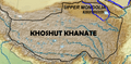
The Khoshut Khanate (1642–1717) based in the Tibetan Plateau
-
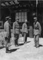
Chiang Kai-shek, leader of Nationalist China (right), meets with the Muslim generals Ma Bufang (second from left), and Ma Buqing (first from left) in Xining, Qinghai, in August 1942
-
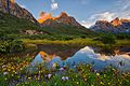
Nyenpo Yurtse, Jigzhi County, Qinghai
-
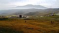
Riyue Mountain in Qinghai


.jpg)
See also
 In Spanish: Qinghai para niños
