
Yellow River facts for kids
Quick facts for kids Yellow River |
|
|---|---|

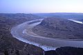
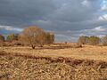
The Yellow River in Sanmenxia, Henan
|
|

Map of the Yellow River, whose watershed covers much of northern China
|
|
| Country | China |
| Province | Qinghai, Sichuan, Gansu, Ningxia, Inner Mongolia, Shaanxi, Shanxi, Henan, Shandong |
| Physical characteristics | |
| Main source | Bayan Har Mountains Yushu Prefecture, Qinghai 4,800 m (15,700 ft) 34°29′31″N 96°20′25″E / 34.49194°N 96.34028°E |
| River mouth | Bohai Sea Kenli District, Dongying, Shandong 0 m (0 ft) 37°45′47″N 119°09′43″E / 37.763°N 119.162°E |
| Length | 5,464 km (3,395 mi) |
| Basin features | |
| Basin size | 752,546 km2 (290,560 sq mi) |
| Tributaries |
|
| Yellow River | |||||||||||||||||||||||||||||
|---|---|---|---|---|---|---|---|---|---|---|---|---|---|---|---|---|---|---|---|---|---|---|---|---|---|---|---|---|---|
.svg)
"Yellow River" in simplified (top) and traditional (bottom) Chinese characters
|
|||||||||||||||||||||||||||||
| Traditional Chinese | 黃河 | ||||||||||||||||||||||||||||
| Simplified Chinese | 黄河 | ||||||||||||||||||||||||||||
|
|||||||||||||||||||||||||||||
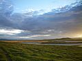
The Yellow River, also known as Huanghe, is China's second-longest river. It is also the sixth-longest river system on Earth. Its estimated length is about 5,464 kilometers (3,395 miles). The river's basin covers about 795,000 square kilometers (307,000 square miles).
The Yellow River starts in the Bayan Har Mountains. It flows generally eastwards through a long loop called the Ordos Loop. This loop runs through Gansu and Inner Mongolia. Then, the river turns south, forming a border between Shanxi and Shaanxi. It later turns east again, flowing across the North China Plain. Finally, it empties into the Bohai Sea. The river gets its name from the yellow color of its water. This color comes from a lot of sediment, or fine soil, picked up as it flows through the Loess Plateau.
The Yellow River basin is considered the birthplace of ancient Chinese civilization. Ancient stories say the Xia dynasty began here around 2100 BC. The river provided rich soil for farming. However, it also flooded often and changed its path many times. Because of this, the Yellow River has been seen as both a blessing and a challenge. It has been called "China's Pride" and "China's Sorrow."
Today, about 120 million people live in the Yellow River basin. Over 420 million people in nearby provinces rely on it for water. The basin includes 13 percent of China's farmland. This area does not get much rain, receiving only 2 percent of China's water runoff. Water and sediment flow have decreased a lot since the 1970s. Until recently, the river often did not reach the sea. Since 2003, China has been working on the South–North Water Transfer Project. This project helps to bring more water to the river.
Contents
- What's in a Name? The Yellow River's Story
- A Look at the Yellow River's Past
- Where the Yellow River Flows
- River Characteristics
- Hydroelectric Power Dams
- Yellow River Crossings
- Yellow River Wildlife: Fish and Other Animals
- Plant Life Along the Yellow River
- Yellow River Pollution
- The Yellow River in Culture
- Exploring the Yellow River
- Images for kids
- See also
What's in a Name? The Yellow River's Story
When the Yellow River's water was clearer, people simply called it 'the river' (He). Records show that the river became muddy between 367 BC and 165 AD. This happened as it left the Loess Plateau.
Later, people started calling it 'murky river' or 'yellow river'. The name "Yellow River" became common by the end of the Tang dynasty. In the Shaanxi loess plateau, some people call it 'river, my lord'. In Mongolian, it is known as Šar mörön, meaning 'yellow river', or Khatan gol, meaning 'queen river'. The Tibetan name is "River of the Peacock."
A Look at the Yellow River's Past
How the River Changes Course and Floods


The Yellow River has always been very important for northern China. Many experts believe it was a birthplace of civilization. However, the river's floods also caused much damage and loss of life. Some of the most severe floods happened in 1344, 1887, and 1931.
Floods happen because the river carries a lot of fine soil, called loess, from the Loess Plateau. This soil settles at the bottom of the river channel. Over time, these deposits build up, creating natural dams. When too much water builds up, it has to find a new path to the sea. This causes the river to burst its banks and flood the flat North China Plain. Sometimes, the river creates a completely new channel.
Historically, people tried to stop floods by building higher and higher levees (walls) along the banks. But if the water broke through these levees, it could not flow back into the riverbed. This was because the riverbed was sometimes higher than the surrounding land. These changes could make the river's mouth shift by hundreds of kilometers. It sometimes reached the ocean north of the Shandong Peninsula and sometimes to the south.
Another cause of floods was the breaking of ice dams in Inner Mongolia. These dams would hold back huge amounts of water. When they broke, they released a sudden rush of water. In modern times, explosives dropped from aircraft are used to break these ice dams before they become dangerous.
Before modern dams were built, the Yellow River flooded very often. Between 595 BC and 1946 AD, it flooded 1,593 times. It changed its main course 26 times noticeably and 9 times severely. These floods are among the deadliest natural disasters ever recorded.
The Yellow River: A Cradle of Chinese Civilization


Ancient Chinese stories tell of the giant Kua Fu who tried to drink the Yellow River. Historical records from ancient times show that the Yellow River once flowed much further north than it does today.
During the time of the Three Sovereigns and Five Emperors (around 21st century BC), the Yellow River flooded many times. A legendary hero named Yu the Great was tasked with controlling these waters. Ancient texts describe how Yu guided the river through mountains and plains. He created nine channels that flowed into the sea. This ancient path is known as the "Yu River."
How the Yu River Changed Its Path
In 602 BC, the river changed its course dramatically. It burst its banks and shifted hundreds of kilometers to the east. This was the first major change in the Yellow River's path recorded since Yu the Great. The new channel flowed eastward and then northward, eventually entering the Bohai Sea. The original Yu River channel slowly dried up.
During the Warring States period, deliberately flooding rival states became a military tactic. The Yellow River valley was a key entry point to the Guanzhong area. The state of Qin heavily guarded the Hangu Pass here. This pass protected the Han capitals of Chang'an and Luoyang. Major floods in 11 AD are thought to have caused the fall of the short-lived Xin dynasty. Another flood in 70 AD moved the river back north of Shandong, close to its current path.
Imperial Times: Managing the Mighty River
From the 3rd century onwards, the importance of the Hangu Pass lessened. Military bases moved further upriver. In 923 AD, a general named Duan Ning broke the dikes to flood an area of 1,000 square miles. He hoped to protect his capital from an invading army, but it failed.
Later, in 1020, a plan to flood the lower parts of the river to protect central plains was rejected. This was because a peace treaty with the Khitai forbade changing river courses. However, breaches still happened. One flood in 1034 split the river into three paths. The Song dynasty tried for five years to fix it but gave up in 1041.
The River's Southern Journey
.jpg)

From 1128 to 1855, the Yellow River flowed south instead of towards the Bohai Sea. It joined the Huai River and emptied into the Yellow Sea. This change happened in 1128 when Song troops broke the southern dikes. They did this to stop the Jin army. This major shift caused the Yellow River to take over the Si River's path. By 1194, the mouth of the Huai River was blocked by silt. Even after the Yellow River moved again, the Huai River could not flow as it used to. Its water now collects in Hongze Lake and flows south to the Yangtze River.
A flood in 1344 caused the Yellow River to shift south of Shandong again. The Yuan dynasty was weakening, and the emperor made huge teams build new river walls. These difficult conditions helped spark rebellions that led to the start of the Ming dynasty. The river changed course again in 1391. It flooded from Kaifeng to Fengyang in Anhui. The river's path was finally made stable by Li Xing after a flood in 1494. The river flooded many times in the 16th century, affecting its lower course.
The 1642 flood was caused by people. The Ming governor of Kaifeng tried to use the river to destroy peasant rebels. He ordered his men to break the dikes, hoping to flood the rebels. Instead, he destroyed his own city. The flood, famine, and disease that followed killed many people. The city was almost empty until it was rebuilt later.
There were many debates in the imperial court about how to control floods. Some officials wanted to build higher walls to protect farmland. Others preferred lower walls with more space for the river to spread out. These debates showed different ideas about how to live with the powerful river.
Traditional flood control used walls, barriers to slow water, overflow areas, and drainage canals. Officials like Pan Jixun wrote about these methods. He believed that joining river branches would make the water stronger and help clear out sediment. However, even with these efforts, a major flood in 1680 submerged the city of Sizhou and the Ming Ancestors Mausoleum under Hongze Lake for centuries. They were only uncovered and restored starting in the 1970s.

From the 19th Century to Today


Between 1851 and 1855, the Yellow River shifted north again. This happened during floods that also led to the Nien Rebellion and Taiping Rebellion. The 1887 flood caused a huge loss of life. It is considered one of the worst natural disasters in history. The Yellow River largely took its current path during the 1897 flood.
Flooding in 1898 left many communities in Shandong very poor. This, along with a drought and other social issues, contributed to the start of the Boxer Rebellion.
The 1931 flood was another terrible event, causing a massive number of fatalities.
On June 9, 1938, during the Second Sino-Japanese War, Nationalist troops broke the river's walls near Huayuankou. This was a military tactic to slow down the advancing Japanese army. The flood covered a large area and caused significant loss of life. It prevented the Japanese Army from taking Zhengzhou but did not stop them from reaching Wuhan.
In 1954, China announced a plan to control Yellow River floods and develop water projects. This plan aimed to reduce flood risks and provide water for farming. Construction began in 1957.
From the 1970s to the 1990s, the river often dried up before reaching the sea. In the 1990s, it failed to reach its mouth for about 180 days each year. In 1997, the Yellow River did not reach the sea for 226 days in a row.
However, there has been good news. As of August 12, 2024, the Yellow River achieved continuous flow for 25 years in a row. This was thanks to unified water flow regulation that started in 1999. Over the 25 years leading up to August 2024, the river supplied over 543.6 billion cubic meters of water. It also provided 1.464 billion cubic meters of water for nature. The number of bird species in the river's wetlands and protected areas increased to 373. This shows a positive recovery of the wetland ecosystem.
Where the Yellow River Flows

The Yellow River basin stretches about 1,900 kilometers (1,180 miles) from east to west. It is about 1,100 kilometers (680 miles) from north to south. Its total area is about 795,000 square kilometers (307,000 square miles).
The Yellow River starts in the Bayan Har Mountains in Qinghai. Its source streams flow into Gyaring Lake and Ngoring Lake. The river then loops northwest and northeast, forming the "Ordos Loop." After that, it flows east across the North China Plain to the Bohai Sea. This basin provides drinking water and irrigation for 140 million people.
The Yellow River flows through seven provinces and two autonomous regions in China. These are Qinghai, Sichuan, Gansu, Ningxia, Inner Mongolia, Shaanxi, Shanxi, Henan, and Shandong. Important cities along the river include Lanzhou, Yinchuan, Baotou, Luoyang, Zhengzhou, Kaifeng, and Jinan. The river's mouth is currently in Kenli County, Shandong.
The river is usually divided into three main parts: the upper, middle, and lower reaches. These parts generally correspond to the mountainous Tibetan Plateau, the Ordos Loop and Loess Plateau, and the North China Plain.
How the River Formed
The Yellow River first formed a long time ago. This happened during the Late Miocene, Pliocene, or Pleistocene periods. It was a result of the Tibetan Plateau rising higher.
The River's Upper Reaches
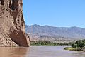
The upper reaches start from the river's source in the Bayan Har Mountains. They end at Hekou Town in Inner Mongolia, where the river turns sharply south. This part is 3,472 kilometers (2,157 miles) long. Its basin covers 386,000 square kilometers (149,000 square miles). The river drops 3,496 meters (11,470 feet) in elevation here.
The source area flows through pastures, swamps, and hills. The water is clear and flows steadily. Two large freshwater lakes, Lake Gyaring and Lake Ngoring, are found here. Much of the source area is part of the Sanjiangyuan National Nature Reserve. This reserve protects the sources of the Yellow River, the Yangtze, and the Mekong.
Further east, the Yellow River enters Gansu. It flows through the Zoigê Wetlands and turns northwest. It then reenters Qinghai and curves north towards the Longyang Gorge.
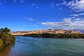
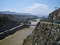
The valley section runs from Longyang Gorge to Qingtong Gorge. Here, steep cliffs line the river. The water flows very fast and turbulently. There are 20 gorges in this section, including Longyang, Jishi, Liujia, Bapan, and Qingtong. These conditions make it ideal for hydroelectric power plants. The city of Lanzhou is built on the river's banks downstream from Yanguo Gorge.
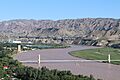
After Qingtong Gorge, the river enters wide alluvial plains, like the Yinchuan Plain and Hetao Plain. In this section, the areas along the river are mostly deserts and grasslands. The water flow is slow. The Hetao Plain is historically important for irrigation along the Yellow River.
-
Zoigê County, Sichuan.
-
Guide County, Qinghai in the Tibetan Plateau, upstream from the Loess Plateau.
-
At Jingtai, Gansu.
-
Liujiaxia, Gansu.
-
The mouth of the Daxia River flowing into the Yellow River's Liujiaxia Reservoir in Linxia, Gansu.


The River's Middle Reaches
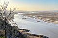
The middle reaches officially run from Hekou in Inner Mongolia to Zhengzhou, Henan. This section is 1,206 kilometers (749 miles) long. Its basin covers 344,000 square kilometers (133,000 square miles). The river drops 890 meters (2,920 feet) in elevation here. Thirty large tributaries join the river in this section, increasing its water flow. The middle reaches also contribute 92% of the river's silt.
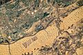
The middle stream passes through the Loess Plateau, where a lot of soil is washed away. This makes the Yellow River the most sediment-laden river in the world. In 1933, 3.91 billion tons of silt were discharged into the river. The highest silt concentration was recorded in 1977. These sediments later settle in the slower lower reaches. This raises the riverbed and creates the famous "river above ground." From Hekou to Yumenkou, the river flows through the Jinshan Valley. This area is good for building hydroelectric power plants. The famous Hukou Waterfall is in this valley.
-
At Shapotou, Ningxia, with desert surrounding it.
-
At Dalad, Baotou, Inner Mongolia.
-
Hukou Waterfalls in Yichuan, Shaanxi.
-
Qiankun bend in Yonghe, Shanxi.
-
At Xingyang, Henan.
.jpg)


The River's Lower Reaches
In the lower reaches, from Zhengzhou to its mouth, the river flows for 786 kilometers (488 miles). It is kept within levees as it flows northeast across the North China Plain. It then empties into the Bohai Sea. The basin area here is only 23,000 square kilometers (8,900 square miles). This is because few tributaries join the river in this section. The river drops 93.6 meters (307 feet) in elevation here.
The silt from the middle reaches settles here, raising the riverbed. This excessive sediment has raised the riverbed several meters above the surrounding land. This is why this part of the river is called the 'Earth Suspended River'. At Kaifeng, Henan, the Yellow River is 10 meters (33 feet) above the ground level.
-
Dongping Lake, the largest tributary in lower reaches of Yellow River.
-

Train No. K1531 passes Longju Bridge over Yellow River near Lijin, Shandong.
-
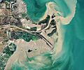
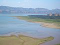
Yellow River Delta.
-
Willows near the delta at Dongying, Shandong.
-
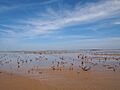
Mudflat near the delta.


Yellow River Tributaries

Here are some of the rivers that flow into the Yellow River, listed from its source to its mouth:
- White River
- Daxia River
- Tao River
- Huang Shui
- Datong River
- Zhuanglang River
- Zuli River
- Qingshui River
- Dahei River
- Kuye River
- Wuding River
- Fen River
- Wei River (the Wei River is the largest tributary)
- Luo River
- Qin River
- Dawen River
The lower reaches of the Yellow River have no tributaries.
River Characteristics
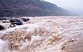
The Yellow River is famous for carrying a huge amount of silt. About 1.6 billion tons of silt are carried each year from the Loess Plateau. If the river has enough water, 1.4 billion tons reach the sea every year. One estimate says there are 34 kilograms of silt per cubic meter of water. This is much more than rivers like the Colorado River or the Nile.
The river's average water flow is about 2,110 cubic meters per second. The highest flow can be 25,000 cubic meters per second, and the lowest is 245. However, since 1972, the river has often dried up before reaching the sea. This low water volume is due to increased irrigation for farming, which has grown five times since 1950. As of 1999, water from the river served 140 million people and irrigated 74,000 square kilometers (28,570 square miles) of land. The Yellow River delta covers about 8,000 square kilometers (3,089 square miles). However, because less silt reaches the sea, the delta has been shrinking slightly each year since 1996 due to erosion.
The most water flows during the rainy season, from July to October. During this time, 60% of the river's annual water volume flows. The most water is needed for irrigation between March and June. To store extra water for use when needed, and for flood control and electricity, several dams have been built. However, their lifespan is limited because of the high amount of silt. A plan called the South–North Water Transfer Project aims to bring water from the Yangtze River to the Yellow River.
Because it carries so much silt, the Yellow River is a depositing stream. This means it drops some of its soil in its bed where the water flows slowly. These deposits raise the riverbed, which flows between natural levees in its lower parts. If a flood happens, the river can break through these levees. It then flows into the lower flood plain and creates a new channel. Historically, this happened about once every hundred years. In modern times, a lot of effort has gone into strengthening levees and controlling floods.
Hydroelectric Power Dams

Many hydroelectric power stations have been built on the Yellow River. They help control floods and generate electricity. Here is a list of some of them:
- Sanmenxia Dam (1960; Sanmenxia, Henan)
- Sanshenggong Dam (1966; Dengkou County, Inner Mongolia)
- Qingtong Gorge Hydroelectric Power Station (1968; Qingtongxia, Ningxia)
- Liujiaxia Dam (Liujia Gorge) (1974; Yongjing County, Gansu)
- Yanguoxia Dam (Yanguo Gorge) (1975; Yongjing County, Gansu)
- Tianqiao Dam (1977; Border at Baode County, Shanxi and Fugu County, Shaanxi)
- Bapanxia Dam (Bapan Gorge) (1980; Xigu District, Lanzhou, Gansu)
- Longyangxia Dam (1992; Gonghe County, Qinghai)
- Lijiaxia Dam (1997) (Jainca County, Qinghai)
- Da Gorge hydroelectric power station (1998, Lanzhou, Gansu)
- Li Gorge hydroelectric power station (1999, Hualong County, Haidong, Qinghai)
- Wanjiazhai Dam (1999; Pianguan County, Shaanxi and Inner Mongolia)
- Xiaolangdi Dam (2001) (Jiyuan, Henan)
- Laxiwa Dam (2010) (Guide County, Qinghai)
- Yangqu Dam (2016) (Xinghai County, Qinghai)
- Maerdang Dam (2018) (Maqên County, Qinghai)
In 2000, the seven largest power plants had a total capacity of 5,618 megawatts.
Yellow River Crossings


Many bridges and ferries cross the Yellow River. They connect different provinces and cities. Here are some of the main crossings, listed from downstream to upstream:
- Dongying Yellow River Bridge
- Shengli Yellow River Bridge (Dongying)
- Lijin Yellow River Bridge (Dongying)
- Binzhou Yellow River Road-Railway Bridge
- Binzhou Yellow River Highway Bridge
- Binzhou–Laiwu Expressway Binzhou Yellow River Bridge (Binzhou–Zibo)
- Huiqing Yellow River Bridge (Binzhou–Zibo)
- Jiyang Yellow River Bridge (Jinan)
- G20 Qingdao–Yinchuan Expressway Jinan Yellow River Bridge (Jinan)
- Jinan Yellow River Bridge
- Luokou Yellow River Railway Bridge (Jinan)
- Jinan Jianbang Yellow River Bridge
- Beijing–Shanghai High-speed Railway Jinan Yellow River Bridge (Jinan–Dezhou)
- Beijing–Taipei Expressway Jinan Yellow River Bridge (Jinan–Dezhou)
- Beijing–Shanghai Railway Jinan Yellow River New Bridge (Jinan–Dezhou)
- Pingyin Yellow River Bridge (Jinan-Liaocheng)
Shandong–Henan
- Beijing–Kowloon Railway Sunkou Yellow River Bridge (Jining–Puyang)
- Juancheng Yellow River Highway Bridge (Heze–Puyang)
- Dongming Yellow River Highway Bridge (Heze–Puyang)
Henan
Shanxi–Henan
- Sanmen Yellow River Bridge (Sanmenxia)
Shaanxi–Henan
- Hancheng Yumenkou Yellow River Bridge
- Yinchuan Yellow River Bridge (Yinchuan)
- Baotou Yellow River Bridge (Baotou)
- Lanzhou Yellow River Bridge
- Zhongshan Bridge (Lanzhou)
- Dari Yellow River Bridge
- Jianzha Yellow River Bridge
Yellow River Wildlife: Fish and Other Animals
Fish and Their Life Cycle

The Yellow River basin is home to many kinds of fish. More than 160 native species have been found here. Nineteen of these species are found nowhere else in the world. However, many native fish have decreased or disappeared. This is due to habitat loss, pollution, new species, and too much fishing. Several are now considered threatened. Dams have created more habitat for slow-moving water species. But they have also blocked the movement of fish that need to travel upstream or downstream to reproduce. In the 2000s, only 80 native fish species were recorded in the Yellow River basin. Meanwhile, the number of introduced fish species has grown.
Cyprinidae (carp family) is the most diverse fish family in the Yellow River basin. Over 85 types of carp have been recorded. Other diverse families include stone loaches, gobies, true loaches, and bagrid catfish. Some species live throughout the river, while others have smaller ranges. For example, the highest parts of the Qinghai–Tibet Plateau have unique species like snowtrout and Triplophysa loaches. Many of these unique species are now threatened. The fish in many headwaters are now mostly introduced salmon. The lowest part of the river and its delta are home to many species that can live in both fresh and salty water.
Fishing is still important, but catches have gone down. In 2007, 40% fewer fish were caught compared to earlier times. Large carp and catfish are still present. However, the largest species, like the Chinese paddlefish and sturgeons, have not been seen in the Yellow River basin for about 50 years.
To protect the fish, an annual fishing ban has been in place since 2018. It covers the entire Yellow River basin from April 1 to June 30 each year. A total ban on fishing natural fish started on April 1, 2022, in the upper reaches. This ban covers Qinghai, Sichuan, and Gansu provinces until the end of 2025. For the rest of the basin, the annual ban is now from April 1 to July 31.
Aquaculture and Farmed Animals

The Yellow River is not as suitable for aquaculture (fish farming) as rivers in central and southern China. However, aquaculture is practiced in some areas. One important area is the plain in Xingyang, upstream from Zhengzhou. Since fish ponds started there in 1986, the area has become a large aquaculture center in north China.
Two turtle species are native to the Yellow River basin: the Chinese pond turtle and the Chinese softshell turtle. Both are widely farmed for food. A type of Chinese softshell turtle popular in Chinese food is called the Yellow River turtle. Most of these turtles eaten today come from farms, which may or may not be near the Yellow River. In 2007, a large farm for these turtles started in Wangcun, Henan. It was expected to raise 5 million turtles a year.
The huge Chinese giant salamander is also native to the Yellow River and other Chinese rivers. This species has greatly declined because people hunt it for food and medicine. It is now farmed in large numbers. Studies show that most farmed salamanders come from the Yellow River type. When these are released into the wild, they can spread to other parts of China. This can cause problems for other types of giant salamanders.
Plant Life Along the Yellow River
The Yellow River flows through many different natural areas. These include alpine shrubland, steppe, forest, desert, grassland, and saline meadow. The types of plants vary greatly depending on the location. In the lower regions, where people have developed the land, there are fewer types of plants. These mostly include seepweed, reeds, foxtails, kunai grass, and tamerisk.
Changes in Vegetation
In parts of the river delta that are no longer used, woody plants can grow too much. This leads to fewer types of grassy plants. It also changes the soil and can affect the balance of these wetland ecosystems.
Protecting Plant Life
The Shangqiu Yellow River Ancient Course National Forest Park is a forest created by people outside of Shangqiu. It was made to bring back some of the plant and animal diversity of the Yellow River region. The park has many different kinds of plants and animals. It is also used for research and provides a safe place for some endangered species.
Yellow River Pollution

Pollution is a challenge for the Yellow River. In 2008, a report stated that severe pollution made one-third of the river unusable. This was due to waste from factories and sewage from growing cities. After reaching the first major city, Xining, the river becomes heavily polluted. The Yellow River Conservancy Commission surveyed the river in 2007. They found that 33.8% of the river system was worse than "level five" for water quality. Water at level five is not safe for drinking, farming, or industrial use. The report said that 4.29 billion tons of waste and sewage were discharged into the river that year. Factories and manufacturing caused 70% of this pollution. Households accounted for 23%, and other sources made up over 6%.
The Yellow River in Culture
A traditional belief was that the Yellow River flowed from Heaven. It was seen as a continuation of the Milky Way. In a Chinese legend, Zhang Qian was sent to find the river's source. After sailing for many days, he met a girl spinning and a cow herd. The astrologer Yan Junping later recognized the girl's shuttle as belonging to the Weaving Girl (Vega).
The provinces of Hebei and Henan get their names from the Yellow River. Their names mean "North of the River" and "South of the River," respectively.
Mother River and Cradle of Civilization
Many people believe that Chinese civilization began in the Yellow River basin. The Chinese call the river "the Mother River" and "the cradle of Chinese civilization." Throughout Chinese history, the Yellow River has been seen as both a blessing and a challenge. It has been nicknamed "China's Pride" and "China's Sorrow." In the 20th century, the river became a symbol of the rising Chinese nation. Even before then, many poems and folktales about the Yellow River were passed down. This shows that the river has long been an "emblem of the Chinese spirit."
A River of Challenges
Even though the Yellow River was central to Chinese civilization, its floods and constant changes also caused many disasters. Because of this, it is also known as a River of disaster. Managing the Yellow River has been a big political challenge for many Chinese dynasties.
"When the Yellow River Flows Clear"
Sometimes the Yellow River is called the "Muddy Flow." The Chinese idiom "when the Yellow River flows clear" means something that will probably never happen. It is like the English saying "when pigs fly."
However, "The Yellow River running clear" was once seen as a good sign. This happened during the reign of the Yongle Emperor. It was believed to bring good luck, along with sightings of rare animals.
Exploring the Yellow River

The Yellow River offers several exciting places to visit. These include the Kanbula UNESCO Global Geopark in Qinghai. You can also see the Bingling Grottoes at Liujiaxia Dam and the Yellow River Stone Forest in Gansu. The famous Hukou Waterfall is in Shanxi.
Chinese rafting teams first traveled the entire length of the river in 1986. People have also successfully walked and cycled the entire length of the Yellow River. However, some parts of the upper river banks are hard to reach.
Images for kids
-

Qianlong Emperor’s Southern Inspection Tour, Scroll Four, which depicts the scene of confluence of the Huai and Yellow River
See also
 In Spanish: Río Amarillo para niños
- Central Plain (China)
- Geography of China
- He Bo
- List of rivers in China
- List of most-polluted rivers
- North China Plain
- North China University of Water Conservancy and Electric Power
- Water resources of China
- Yellow River Cantata
- Yellow River floods
- Yellow River management
- Yellow River Map
- Yellow River Delta National Nature Reserve
- Yellow River Piano Concerto
- Yellow Sea
- Red River (disambiguation)
