
Qinghai–Tibet railway facts for kids
Quick facts for kids Qinghai–Tibet railwayམཚོ་བོད་ལྕགས་ལམ། 青藏铁路 |
|
|---|---|

A train pulled by a pair of NJ2 locomotives travels on the Qingzang railway in 2008
|
|
| Overview | |
| Status | Operational |
| Locale | |
| Termini | Xining railway station Lhasa railway station |
| Service | |
| Type | Heavy rail |
| System | |
| Operator(s) | China Railway Qingzang Group |
| History | |
| Opened | 1984 (Xining–Nanshankou) 2006 (Nanshankou–Lhasa) |
| Technical | |
| Line length | 1,956 km (1,215 mi) |
| Number of tracks | 1 (Single-track railway) |
| Track gauge | 1,435 mm (4 ft 8 1⁄2 in) standard gauge |
| Electrification | Overhead catenary 25kV 50Hz (Xining–Golmud) |
| Operating speed | 160 km/h (99 mph) (Xining–Golmud) 100 km/h (62 mph) (Golmud–Lhasa) |
|
|
This article contains Tibetan script. Without the correct software, you may see question marks, boxes, or other symbols instead of Tibetan characters. |

The Qinghai–Tibet railway, also known as the Qingzang railway, is a special train line in China. It connects Xining in Qinghai Province to Lhasa in the Tibet Autonomous Region. This railway is famous for being built at very high elevations.
The total length of the railway is about 1,956 kilometers (1,215 miles). The first part, from Xining to Golmud, was finished in 1984. The second, more challenging part, from Golmud to Lhasa, opened on July 1, 2006. This was a big moment because it was the first time Tibet was connected to other parts of China by train.
This railway holds several world records. It crosses the Tanggula Pass, which is the highest point on any railway in the world, at 5,072 meters (16,640 feet) above sea level. The Tanggula railway station is also the highest train station in the world. Plus, the Fenghuoshan tunnel is the highest railway tunnel, reaching 4,905 meters (16,093 feet) high. A large part of the railway, over 960 kilometers (597 miles), is built at elevations higher than 4,000 meters (13,123 feet).
Contents
Stations Along the Railway
The railway has many stations, especially on the Golmud to Lhasa section. There are 45 stations, and 38 of them are not staffed. They are watched over by a control center in Xining. More stations are planned for the future.

● Station with vista point
Note: stations in gray are unstaffed
Note: this image is not to scale
| Main Stations | |||||
|---|---|---|---|---|---|
| English name | Chinese name | Distance from Xining in km (mi) |
Coordinates | Altitude | |
| Xining | 西宁 | ||||
| Xining West | 西宁西 | 12 km (7.5 mi) | 36°39′28″N 101°41′14″E / 36.65778°N 101.68736°E | 2282 m | |
| Tongkor | 湟源 | 58 km (36 mi) | 36°41′02″N 101°14′23″E / 36.68384°N 101.23963°E | 2650 m | |
| Haiyan | 海晏 | 97 km (60 mi) | 36°52′01″N 100°59′37″E / 36.86703°N 100.99359°E | 3074 m | |
| Qinghai Lake | 青海湖 | 133 km (83 mi) | |||
| Hargai | 哈尔盖 | 177 km (110 mi) | 37°10′59″N 100°24′57″E / 37.18308°N 100.41576°E | 3248 m | |
| Gangcha | 刚察 | 208 km (129 mi) | 37°14′38″N 100°05′54″E / 37.24375°N 100.09843°E | 3238 m | |
| Chahannuo | 察汗诺 | 364 km (226 mi) | |||
| Ulan | 乌兰 | 407 km (253 mi) | 36°57′14″N 98°28′03″E / 36.95397°N 98.46755°E | 3017 m | |
| Keke | 柯柯 | 426 km (265 mi) | 36°59′02″N 98°15′18″E / 36.98391°N 98.25511°E | 2966 m | |
| Taoli | 陶力 | 474 km (295 mi) | |||
| Delingha | 德令哈 | 521 km (324 mi) | 37°18′51″N 97°22′59″E / 37.314287°N 97.38301°E | 2945 m | |
| Lianhu | 连湖 | 563 km (350 mi) | |||
| Hangya | 航垭 | 639 km (397 mi) | |||
| Yinmaxia | 饮马峡 | 675 km (419 mi) | 37°19′26″N 95°52′20″E / 37.32396°N 95.87227°E | 3151 m | |
| Xitieshan | 锡铁山 | 699 km (434 mi) | 37°15′28″N 95°38′14″E / 37.25768°N 95.63723°E | 2996 m | |
| Dabusun | 达布逊 | 750 km (470 mi) | 36°55′9″N 95°21′49″E / 36.91917°N 95.36361°E | ||
| Qarhan | 察尔汗 | 764 km (475 mi) | 36°48′37″N 95°18′15″E / 36.81032°N 95.30416°E | 2687 m | |
| Golmud East | 格尔木东 | 808 km (502 mi) | 36°25′08″N 94°55′25″E / 36.41889°N 94.92361°E | ||
| Golmud | 格尔木 | 830 km (520 mi) | 36°22′58″N 94°54′21″E / 36.38278°N 94.90583°E | 2829 m | |
| Nanshankou | 南山口 | 857 km (533 mi) | 36°11′34″N 94°46′46″E / 36.19278°N 94.77944°E | ||
| Budongquan | 不冻泉 | 1,010 km (630 mi) | 35°31.2′N 93°54.3′E / 35.5200°N 93.9050°E | ||
| Tuotuo River | 沱沱河 | 1,239 km (770 mi) | |||
| Buqiangge | 布强格 | 1,380 km (860 mi) | |||
| Tanggula | 唐古拉 | 1,421 km (883 mi) | 32°53′5″N 91°55′6″E / 32.88472°N 91.91833°E | ||
| Amdo | 安多 | 1,524 km (947 mi) | 32°15′8″N 91°39′57″E / 32.25222°N 91.66583°E | ||
| Nagqu | 那曲 | 1,650 km (1,030 mi) | 31°26′45″N 91°59′21″E / 31.44583°N 91.98917°E | 4513 m | |
| Damxung | 当雄 | 1,808 km (1,123 mi) | 30°27.6′N 91°04.8′E / 30.4600°N 91.0800°E | 4293 m | |
| Yangpachen | 羊八井 | 1,881 km (1,169 mi) | |||
| Maxiang | 马乡 | 1,913 km (1,189 mi) | |||
| Lhasa West | 拉萨西 | 1,953 km (1,214 mi) | 29°38′38″N 90°58′00″E / 29.64389°N 90.96667°E | ||
| Lhasa | 拉萨 | 1,972 km (1,225 mi) | 29°37′30″N 91°04′07″E / 29.62500°N 91.06861°E | ||
Special Trains and Tickets
.jpg)
The trains used on the Qinghai–Tibet railway are built especially for high-altitude travel. The engines are very powerful, and the passenger cars are designed to keep people comfortable. Signs inside the trains are in Tibetan, Chinese, and English.
The trains can travel at speeds of 120 kilometers per hour (75 mph) on most parts of the track. However, they slow down to 100 kilometers per hour (62 mph) when crossing areas with permafrost. This is because the ground can be less stable there.

The railway from Golmud to Lhasa officially opened for regular service on July 1, 2006. The train engines are "turbocharged." This helps them work well even when there is less air at high altitudes.
When the railway first opened, trains ran from Beijing, Chengdu, Chongqing, Lanzhou, and Xining to Lhasa. Later, services from Shanghai and Guangzhou were added. These trains can carry many passengers, sometimes up to 1,000 people during busy times.
Oxygen and Health on Board
Because the railway goes through very high places, the air has less oxygen. To keep passengers safe and healthy, the train carriages have a special oxygen supply system. Each seat has an oxygen outlet for emergencies. There is also a doctor on every passenger train.
Passengers traveling between Golmud and Lhasa need to fill out a "Passenger Health Registration Card." This card makes sure that everyone knows about the health considerations for high-altitude travel.
Building the Railway


Building the Qinghai–Tibet railway was a huge challenge. The first part, from Xining to Golmud, was completed in 1984. However, building the remaining 1,142-kilometer (710-mile) section to Lhasa was much harder. Engineers had to figure out how to build tracks on permafrost, which is ground that stays frozen for a long time.
Construction on the Golmud to Lhasa section officially began on June 29, 2001. It took five years to finish and cost about $3.68 billion. The tracks reached the highest point, the Tanggula Pass, on August 24, 2005.
More than 20,000 workers and over 6,000 pieces of heavy equipment were used to build this railway. It is considered one of China's greatest engineering achievements in the 21st century.
Special passenger carriages were built by Bombardier Transportation. These cars have systems to provide extra oxygen and protect against UV rays. Some are even luxury sleeper cars for tourists. The railway project was part of a plan to help develop the western parts of China.
Future Railway Connections
The Qinghai–Tibet railway is part of a larger plan to connect more areas by rail. There are plans to extend the railway from Lhasa to Shigatse and Nyingchi in the Tibet Autonomous Region. Other lines will connect Golmud to Chengdu, Dunhuang, and Korla. Another line will link Xining with Zhangye. Many of these new lines are expected to be ready before 2020.
The railway from Lhasa to Shigatse opened in August 2014. Also, a new railway connecting Dunhuang to Golmud was finished in December 2019. This creates a direct link between Xinjiang and Tibet.
There are also plans to increase the railway's ability to carry more goods. Engineers are even studying if the railway can be electrified. China and Nepal have discussed extending the railway from Shigatse to Kathmandu in Nepal to help with trade and tourism.
Engineering Challenges

Building this railway was very difficult due to the unique environment. About half of the Golmud to Lhasa section is built on permafrost. In summer, the top layer of permafrost can melt, making the ground muddy and unstable. The heat from trains could also melt the permafrost.
Engineers found clever ways to deal with this. In areas where the permafrost was not too fragile, they built the tracks on large rock embankments. In the most fragile areas, they built elevated tracks, like bridges, with strong foundations dug deep into the ground. Some parts of the track are also kept cool using special cooling systems.

Another challenge was the thin air in Tibet, which has much less oxygen than at sea level. As mentioned, special trains with oxygen supplies were designed. The railway also crosses the Kunlun Mountains, an area where earthquakes can happen. Many earthquake monitors have been placed along the railway to detect any ground movement.
Impact of the Railway
Economic Impact
The Tibetan economy relies a lot on products from other parts of China. Before the railway, goods were mostly transported by highway, which was slow and expensive. The Qingzang railway has greatly reduced the cost of moving goods and people. This means more products can be brought into Tibet, and local goods can be sent out. It is expected that the railway will help improve living standards for people along its route.
Social Impact
The railway has brought more tourists to Tibet, creating new jobs for local people. It also makes it easier for Tibetans to travel to other parts of China for education and work. Some people believe the railway helps share Tibetan culture and religion by making it easier for worshippers to visit Lhasa.
Environmental Impact
_(37148431070).jpg)
Building and operating the railway has environmental concerns. Increased tourism and activity could affect the natural environment of the Tibetan Plateau. Engineers tried to reduce this impact. For example, trash on trains is collected in sealed containers and removed at large stations, not thrown onto the tracks.
There are also worries about global warming melting the permafrost that the railway is built on. This could affect the railway's stability in the future. To protect wildlife, like the Tibetan antelope, 33 special bridges were built to allow animals to cross the railway safely during their migrations.
Trains Used
.jpg)
The trains on the Qinghai–Tibet railway are specially designed for the high-altitude environment. They include:
- Passenger carriages built by Bombardier Sifang Power Transportation Ltd. These cars have special systems for oxygen and UV protection.
- Locomotives (train engines) made by GE Transportation, CRRC Qishuyan, CRRC Ziyang Locomotive Factory, CRRC Beijing Locomotive, and CRRC Dalian.
Scenery Along the Railway
The journey on the Qingzang Railway offers amazing views.
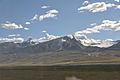
- From Xining to Golmud: You can see the beautiful Qinghai Lake.
- From Golmud to Lhasa:
- Kunlun Pass, part of the Kunlun Mountains, with its Yuzhu Peak and glaciers.
- The Fenghuoshan Tunnel.
- The vast Kekexili Grassland.
- The bridge over the Tuotuo River.
- Tanggula railway station and the stunning Tanggula Mountains.
- The wide Amdo Grassland.
- The peaceful Tsonag Lake.
- The Nagchu Grassland.
- The majestic Nyenchen Tanglha Mountains.
- The Damxung Grassland.
- The bridge over the Lhasa River.
Gallery
-
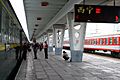
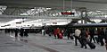
Xining railway station
-
Bridge over the Tongtian River
-
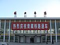
Golmud railway station
-
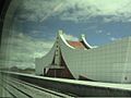
Tanggula railway station
5,068 meters above sea level -
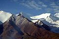
Tanggula Mountains
-
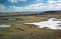
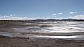
Bridge on permafrost horizon
-
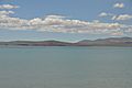
Tsonag Lake
-
Nyenchen Tanglha Mountains
-
Lhasa railway station


.jpg)


See also
 In Spanish: Ferrocarril Qinghai–Tíbet para niños
- List of highest railways
- Sichuan–Tibet railway
