
Dunhuang facts for kids
Quick facts for kids
Dunhuang
敦煌市
Tunhwang
|
|
|---|---|
|
County-level city
|
|

Dunhuang
|
|
.png)
Dunhuang City (red) in Jiuquan City (yellow) and Gansu
|
|

Dunhuang
Location in Gansu

Dunhuang
Location in China
|
|
| Country | China |
| Province | Gansu |
| Prefecture-level city | Jiuquan |
| Municipal seat | Shazhou Town |
| Area | |
| • Total | 31,200 km2 (12,000 sq mi) |
| Elevation | 1,142 m (3,747 ft) |
| Population
(2020)
|
|
| • Total | 185,231 |
| • Density | 5.937/km2 (15.376/sq mi) |
| Time zone | UTC+8 (CST) |
| Postal Code |
736200
|
| Dunhuang | |||||||||||||||||
|---|---|---|---|---|---|---|---|---|---|---|---|---|---|---|---|---|---|
.svg)
"Dunhuang" in Chinese characters
|
|||||||||||||||||
| Chinese | 敦煌 | ||||||||||||||||
| Postal | Tunhwang | ||||||||||||||||
| Literal meaning | "Blazing Beacon" | ||||||||||||||||
|
|||||||||||||||||
Dunhuang is a city in northwestern Gansu Province, China. It's home to about 191,800 people (2019 estimate). Dunhuang was a very important stop on the ancient Silk Road, a famous trade route. It is best known for the amazing Mogao Caves nearby.
The city is built in an oasis, which is a green area in a desert. This oasis has a beautiful Crescent Lake and the Mingsha Shan (meaning "Singing-Sand Mountain"). These dunes are named for the sound the wind makes as it blows across them, like a "singing sand" phenomenon. Dunhuang was in a key location because it sat at the crossing point of the Southern Silk Route and a main road from India to Mongolia and Siberia. It also controlled the narrow Hexi Corridor, which led right into the heart of northern China.
Today, Dunhuang is part of the larger city of Jiuquan. In the past, it was also called Shazhou (meaning "prefecture of sand") or Guazhou (meaning "prefecture of melons").
What's in a Name?
The name Dunhuang has a few possible meanings. Some scholars think it means "blazing beacon," referring to the signal fires used to warn of attacks. Other ideas include "honest and shining" or "to shimmer and shine."
A Look Back in Time
Early History of Dunhuang
People have lived in the Dunhuang area for a very long time, possibly as far back as 2,000 BC. This region was known for growing melons. The area was also home to different groups of people, like the Dayuezhi, Wusun, and Saizhong (Scythians).
Dunhuang in the Han Dynasty

Around 300 BC, the area was controlled by the Xiongnu people. But in 121 BC, the Chinese Emperor Wu defeated them. Dunhuang then became one of four important military towns built by the Han dynasty to protect the border. The Chinese built strong walls and sent people to live there. The name Dunhuang, meaning "Blazing Beacon," comes from the signal fires lit to warn of attacks from nomadic tribes.
Dunhuang was very important for the Silk Road. It was a key place for caravans to stop, load up on water and food, and rest before or after their long journeys through the desert. By the second century AD, Dunhuang had over 76,000 people and was a busy, thriving city.
Dunhuang: A Crossroads of Cultures

During the Sui dynasty (581–618) and Tang dynasty (618–907), Dunhuang was a major center for trade and communication between China and the rest of the world. It was where all three main Silk Road routes met.
Many early Buddhist monks traveled along the Silk Road and came to China. A large Buddhist community grew in Dunhuang. These monks carved caves for meditation, which later became places of worship and pilgrimage. These are the famous Mogao Caves, also known as the "Caves of a Thousand Buddhas." These caves are filled with beautiful murals and statues. Other items, like Christian and Jewish artifacts, have also been found in the caves, showing how many different people traveled the Silk Road.
Because it was a border town, different groups sometimes took control of Dunhuang. After the Han dynasty fell, it was ruled by various nomadic tribes. The Tibetans also occupied Dunhuang for a time.

From 848 to about 1036, Dunhuang was a multicultural hub. It had one of the largest communities of Sogdian people in China. The Sogdians were traders from Central Asia who learned Chinese and wrote their documents in Chinese characters.
Later Dynasties and Modern Times
In 1227, the Mongols conquered Dunhuang, and it became part of the Mongol Empire under the Yuan dynasty.
During the Ming dynasty, China started using sea routes more for trade, and the Silk Road became less important. Dunhuang declined during this time. It was taken over by Tibetans again around 1516.
China took back Dunhuang around 1715 during the Qing dynasty. The modern city of Dunhuang was built in 1725, a bit east of the old ruined city.
In 1988, Dunhuang officially became a county-level city. Today, it's a very important tourist spot and a place where archaeologists continue to make discoveries. The Kumtag Desert is slowly growing and reaching the edges of the city, partly because of too much grazing by animals in the past.
Culture and Attractions
Amazing Buddhist Caves
The Dunhuang area is home to several Buddhist cave sites. The most famous are the Mogao Caves, located about 25 kilometers (15.5 miles) southeast of the city. There are 735 caves at Mogao! These caves are famous for their incredible Buddhist art, including murals and statues. Many ancient manuscripts, known as the Dunhuang manuscripts, were also found hidden in a sealed cave. These discoveries continue to be made, even including parts of a Christian Bible from the Yuan dynasty.
Other smaller Buddhist cave sites in the area include the Western Thousand Buddha Caves and the Eastern Thousands Buddha Caves.
Other Cool Historical Sites

- Crescent Lake and Singing Sand Dunes: These natural wonders are a must-see.
- The Yumen Pass: Built in 111 BC, this ancient pass is about 90 kilometers (56 miles) northwest of Dunhuang in the Gobi desert.
- The Yang Pass: Another historic pass.
- White Horse Pagoda: A beautiful pagoda.
- Dunhuang Limes: Ancient border defenses.
Museums and Markets
- Dunhuang County Museum: Here you can learn more about the city's long history.
- Dunhuang Night Market: This market is held on the main street in the city center. It's very popular with tourists in the summer. You can find many souvenirs like jade, jewelry, scrolls, and small sculptures. Many people from China's ethnic minorities sell their goods here. You can also try a Central Asian sweet made with nuts and dried fruit.
Geography and Climate
Dunhuang's Climate
Dunhuang has a cool desert climate. It gets very little rain, only about 67 millimeters (2.6 inches) per year, mostly in summer. Winters are long and cold, with an average temperature of about -8.3°C (17.1°F) in January. Summers are hot, with an average of 24.6°C (76.3°F) in July. The temperature can change a lot between day and night, by about 16.1°C (29°F) on average.
Dunhuang gets a lot of sunshine, about 3,258 hours a year, making it one of the sunniest places in China. Because of all this sunshine, the Gansu Dunhuang Solar Park was built nearby to use solar energy.
| Climate data for Dunhuang, elevation 1,139 m (3,737 ft), (1991–2020 normals, extremes 1971–2000) | |||||||||||||
|---|---|---|---|---|---|---|---|---|---|---|---|---|---|
| Month | Jan | Feb | Mar | Apr | May | Jun | Jul | Aug | Sep | Oct | Nov | Dec | Year |
| Mean daily maximum °C (°F) | −0.8 (30.6) |
6.0 (42.8) |
14.3 (57.7) |
22.4 (72.3) |
27.7 (81.9) |
31.9 (89.4) |
33.5 (92.3) |
32.3 (90.1) |
27.3 (81.1) |
19.4 (66.9) |
9.3 (48.7) |
0.6 (33.1) |
18.7 (65.6) |
| Daily mean °C (°F) | −8.1 (17.4) |
−2.1 (28.2) |
5.9 (42.6) |
13.7 (56.7) |
19.4 (66.9) |
24.1 (75.4) |
25.8 (78.4) |
23.9 (75.0) |
17.7 (63.9) |
9.2 (48.6) |
1.2 (34.2) |
−6.3 (20.7) |
10.4 (50.7) |
| Mean daily minimum °C (°F) | −14.2 (6.4) |
−9.0 (15.8) |
−1.5 (29.3) |
5.5 (41.9) |
10.7 (51.3) |
15.7 (60.3) |
18.0 (64.4) |
15.9 (60.6) |
9.7 (49.5) |
1.5 (34.7) |
−5.0 (23.0) |
−11.9 (10.6) |
2.9 (37.3) |
| Average precipitation mm (inches) | 1.2 (0.05) |
0.5 (0.02) |
2.1 (0.08) |
3.2 (0.13) |
5.7 (0.22) |
8.7 (0.34) |
11.2 (0.44) |
5.9 (0.23) |
2.7 (0.11) |
0.9 (0.04) |
1.1 (0.04) |
1.4 (0.06) |
44.6 (1.76) |
| Average precipitation days (≥ 0.1 mm) | 1.8 | 0.9 | 1.3 | 1.4 | 1.9 | 3.1 | 3.9 | 2.7 | 1.6 | 0.6 | 0.9 | 1.9 | 22 |
| Average snowy days | 3.2 | 1.3 | 1.2 | 0.4 | 0 | 0 | 0 | 0 | 0.1 | 0.2 | 1.5 | 3.5 | 11.4 |
| Average relative humidity (%) | 54 | 39 | 33 | 28 | 30 | 37 | 42 | 44 | 45 | 45 | 49 | 56 | 42 |
| Mean monthly sunshine hours | 221.9 | 220.9 | 265.1 | 288.1 | 328.3 | 321.6 | 317.9 | 315.0 | 294.9 | 283.8 | 231.7 | 209.9 | 3,299.1 |
| Percent possible sunshine | 73 | 72 | 71 | 72 | 73 | 72 | 70 | 75 | 80 | 84 | 79 | 73 | 75 |
| Source: China Meteorological Administration | |||||||||||||
City Life and People
Local Government
Dunhuang is divided into nine towns and one other area. These smaller areas then manage 56 villages.
Who Lives in Dunhuang?
In 2019, about 191,800 people lived in Dunhuang. Most of the people (97.8%) are Han Chinese. The remaining 2.2% belong to 27 different ethnic groups, including Hui, Mongol, Tibetan, and Uyghur people.
Economy of Dunhuang
Dunhuang's economy relies on different areas. In 2020, its total economic output was about 7.778 billion Chinese Yuan. This includes money from farming (primary sector), manufacturing (secondary sector), and services like tourism (tertiary sector).
Getting Around Dunhuang

Dunhuang is connected by China National Highway 215 and has its own airport, Dunhuang Mogao International Airport.
There's also a railway line called the Dunhuang railway. It connects Dunhuang to other major cities like Lanzhou and Xi'an. The Dunhuang train station is located northeast of the city, close to the airport. This railway line has also been extended south into Qinghai, connecting Dunhuang to the Qingzang railway.
See also
- Three hares
- Mogao caves
- Yangguan
- Yueyaquan
Images for kids
-
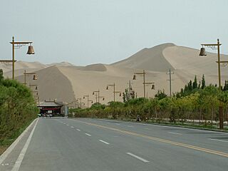
The Singing Sand Dunes on the eastern edge of the Kumtag Desert near Dunhuang.
-
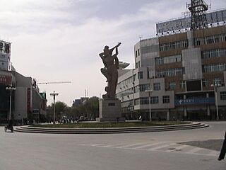
Sculpture in Dunhuang, after a mural in Mogao Caves, depicting an Apsara playing the pipa behind her back (Chinese: 反弹琵琶伎乐天).
-
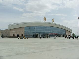
Dunhuang Airport
-
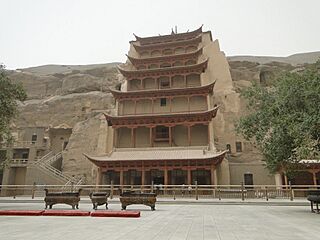
Mogao Caves, also known as Dunhuang Grottoes.
-
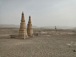
Lonely monuments in the desert near Donghuan
-
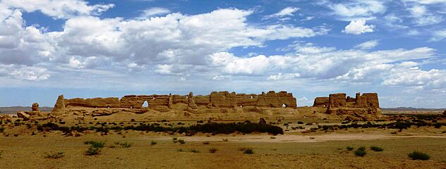
Rammed earth ruins of a granary
.jpg)


.jpg)


