
Lhasa facts for kids
Quick facts for kids
Lhasa
拉萨市 城关区
ཁྲིན་ཀོན་ཆུས། · ल्हासा Chengguan, Chênggoin, Chengguān
|
|
|---|---|
|
District
|
|
| District of Chengguan of the City of Lhasa | |
|
|
|

Lhasa
Location in Tibet

Lhasa
Location in China
|
|
| Country | China |
| Autonomous region | Tibet |
| Prefecture-level city | Lhasa |
| District seat | Gyirai Subdistrict |
| Area | |
| • District | 525 km2 (203 sq mi) |
| • Urban
|
168 km2 (65 sq mi) |
| Elevation | 3,656 m (11,995 ft) |
| Population
(2020)
|
|
| • District | 464,736 |
| • Density | 885.2/km2 (2,292.7/sq mi) |
| • Urban
(2020)
|
464,736 |
| • Major Ethnic groups | Tibetan; Han; Hui; Nepali |
| • Languages | Tibetan; Mandarin |
| Time zone | UTC+8 (China Standard) |
| Postal code |
850000
|
| Area code(s) | 891 |

.jpg)

.jpg)
_(28768122237).jpg)
| Lhasa | |||||||||||||
|---|---|---|---|---|---|---|---|---|---|---|---|---|---|
.svg) |
|||||||||||||
| Chinese name | |||||||||||||
| Simplified Chinese | 拉萨 | ||||||||||||
| Traditional Chinese | 拉薩 | ||||||||||||
| Literal meaning | (in Tibetan) "Place of the Gods" | ||||||||||||
|
|||||||||||||
| Historical Chinese name | |||||||||||||
| Simplified Chinese | 逻些 | ||||||||||||
| Traditional Chinese | 邏些 | ||||||||||||
|
|||||||||||||
| Tibetan name | |||||||||||||
| Tibetan | ལྷ་ས་ | ||||||||||||
|
|||||||||||||
Lhasa is the main urban area of Lhasa City in the Tibet Autonomous Region of China. It is often called the Chengguan District of Lhasa City.
Lhasa is the second largest city on the Tibetan Plateau, after Xining. It sits very high up, at about 3,656 meters (11,995 feet) above sea level. This makes Lhasa one of the highest cities in the world. Since the mid-1600s, Lhasa has been the religious and government center of Tibet. It is home to many important Tibetan Buddhist sites, like the famous Potala Palace, Jokhang Temple, and Norbulingka Palaces.
Contents
What's in a Name?
The name "Lhasa" means "place of gods" in the Tibetan language. The word lha means "god," and sa means "place."
The Chinese name for the area, Chengguan, means "urban gateway." Long ago, Tibetan records show the place was called Rasa, which meant "goat's place." This was because it used to be a place where goats grazed. The name changed to Lhasa when it became the capital of Tibet. This happened after the Jokhang temple was built there, which holds a holy statue of the Buddha.
A Look Back in Time

In the mid-600s, Songtsen Gampo became the leader of the Tibetan Empire. He moved the capital to Rasa (Lhasa) in 637 CE. He started building the first structures on the site of what is now the Potala Palace.
Songtsen Gampo married Princess Bhrikuti from Nepal and Princess Wencheng from the Chinese Tang dynasty. Both princesses were Buddhist. In 641 CE, he built the Jokhang and Ramoche Temples in Lhasa. These temples were made to hold two important Buddha statues brought by the princesses.
In the 9th century, during the time of Langdarma, Lhasa faced challenges. Holy sites were damaged, and the empire broke apart. For a long time after this, Lhasa was not the main political center of Tibet. However, it grew more and more important as a religious place.
By the 1400s, Lhasa became very well known. This was thanks to Je Tsongkhapa and his students, who founded three large Gelugpa monasteries: Ganden, Sera, and Drepung. These monasteries helped bring back a pure form of Buddhism in Tibet.
The 5th Dalai Lama, Lobsang Gyatso, brought Tibet together in 1642. He moved his government to Lhasa. In 1645, work began on rebuilding the Potala Palace. The White Palace part of the Potala was finished in 1648. From then on, the Dalai Lama used it as his winter palace. The Red Palace was added later, between 1690 and 1694. The Jokhang Temple was also made much larger around this time.

By the late 1600s, Lhasa's Barkhor area was a busy market. Traders from many places, like Mongolia, China, Nepal, and India, came here. Tibet traded things like musk, gold, and furs for sugar, tea, and jewels.
In 1720, the Qing dynasty army entered Lhasa. They sent special officials called Ambans to oversee the city. In 1750, a riot broke out in Lhasa after the regent was killed. After this, the Qing Qianlong Emperor set up a new government council called Kashag in Lhasa in 1751.

In 1904, a British force entered Lhasa. Their leader, Francis Younghusband, made a treaty with Tibetan officials. All Qing troops left Lhasa in 1912.
In 1951, the Chinese People's Liberation Army entered Lhasa. In 1959, after an uprising, the 14th Dalai Lama left Tibet. Lhasa remained the main center of Tibet. In 1960, Lhasa City was officially created. By 1965, Lhasa became the capital of the Tibet Autonomous Region.
Where is Lhasa?


Lhasa is about 3,600 meters (11,800 feet) high. It is in the middle of the Tibetan Plateau. The mountains around it rise to about 5,500 meters (18,000 feet). Because it's so high, the air has less oxygen than at sea level.
The Lhasa River, also called Kyi Chu, flows through the southern part of the city. This river is known for its "merry blue waves." It flows from snowy peaks and joins the larger Yarlung Zangbo River.
City Layout

The Chengguan District is the inner city area of Lhasa. It is about 28 kilometers (17 miles) from east to west and 31 kilometers (19 miles) from north to south. Most of the Chengguan District outside the city is mountainous, with very few people living there.
The average temperature in Chengguan District is about 8°C (46°F). It gets about 300 to 500 millimeters (12 to 20 inches) of rain each year, mostly in July, August, and September.
Climate


Lhasa has a cool, dry climate. Winters are frosty, and summers are mild. The city is protected by its valley location, so it avoids extreme cold or heat and strong winds.
Lhasa gets almost 3,000 hours of sunlight every year. This is why Tibetans sometimes call it the "sunlit city." January is the coldest month, with an average temperature of -0.3°C (31.5°F). June is the warmest, with an average of 16.7°C (62.1°F).
Most of the rain falls in July, August, and September. December is the driest month. Summer is a popular time to visit because it rains mostly at night, and the days are still sunny.
| Climate data for Lhasa, elevation 3,649 m (11,972 ft), (1991–2020 normals, extremes 1951–2022) | |||||||||||||
|---|---|---|---|---|---|---|---|---|---|---|---|---|---|
| Month | Jan | Feb | Mar | Apr | May | Jun | Jul | Aug | Sep | Oct | Nov | Dec | Year |
| Record high °C (°F) | 20.5 (68.9) |
21.3 (70.3) |
25.1 (77.2) |
25.9 (78.6) |
29.4 (84.9) |
30.8 (87.4) |
30.4 (86.7) |
27.2 (81.0) |
26.5 (79.7) |
24.8 (76.6) |
22.8 (73.0) |
20.1 (68.2) |
30.8 (87.4) |
| Mean daily maximum °C (°F) | 8.3 (46.9) |
10.4 (50.7) |
13.4 (56.1) |
16.5 (61.7) |
20.5 (68.9) |
23.9 (75.0) |
23.3 (73.9) |
22.3 (72.1) |
21.1 (70.0) |
17.9 (64.2) |
13.3 (55.9) |
9.7 (49.5) |
16.7 (62.1) |
| Daily mean °C (°F) | 0.6 (33.1) |
3.1 (37.6) |
6.5 (43.7) |
9.8 (49.6) |
13.8 (56.8) |
17.5 (63.5) |
17.5 (63.5) |
16.7 (62.1) |
15.2 (59.4) |
10.8 (51.4) |
5.4 (41.7) |
1.7 (35.1) |
9.9 (49.8) |
| Mean daily minimum °C (°F) | −7.1 (19.2) |
−4.2 (24.4) |
−0.5 (31.1) |
3.1 (37.6) |
7.1 (44.8) |
11.1 (52.0) |
11.7 (53.1) |
11.1 (52.0) |
9.3 (48.7) |
3.7 (38.7) |
−2.5 (27.5) |
−6.3 (20.7) |
3.0 (37.5) |
| Record low °C (°F) | −16.5 (2.3) |
−15.4 (4.3) |
−13.6 (7.5) |
−8.1 (17.4) |
−2.7 (27.1) |
2.0 (35.6) |
4.5 (40.1) |
3.3 (37.9) |
0.3 (32.5) |
−7.2 (19.0) |
−11.2 (11.8) |
−16.1 (3.0) |
−16.5 (2.3) |
| Average precipitation mm (inches) | 0.9 (0.04) |
1.9 (0.07) |
3.5 (0.14) |
8.3 (0.33) |
31.1 (1.22) |
84.0 (3.31) |
140.5 (5.53) |
129.8 (5.11) |
64.8 (2.55) |
6.5 (0.26) |
0.9 (0.04) |
0.7 (0.03) |
472.9 (18.63) |
| Average precipitation days (≥ 0.1 mm) | 0.6 | 1.2 | 2.4 | 5.2 | 9.5 | 14.4 | 19.8 | 19.1 | 13.5 | 3.5 | 0.6 | 0.5 | 90.3 |
| Average snowy days | 1.3 | 2.2 | 5.5 | 5.6 | 0.9 | 0 | 0 | 0 | 0.1 | 1.1 | 1.3 | 0.7 | 18.7 |
| Average relative humidity (%) | 25 | 24 | 27 | 36 | 41 | 48 | 59 | 61 | 57 | 43 | 32 | 27 | 40 |
| Mean monthly sunshine hours | 250.0 | 234.4 | 256.0 | 254.3 | 279.8 | 260.4 | 227.5 | 223.5 | 238.4 | 280.6 | 266.2 | 256.5 | 3,027.6 |
| Percent possible sunshine | 77 | 74 | 68 | 65 | 66 | 62 | 54 | 55 | 65 | 80 | 84 | 81 | 69 |
| Source: China Meteorological Administrationall-time extreme temperature | |||||||||||||
People of Lhasa


Lhasa is home to many different groups of people. The total population of Lhasa City is about 521,500. Nearly half of these people live in the Chengguan District, which is the main city area.
The city has people from different ethnic groups, including Tibetans, Han Chinese, and Hui. In 2010, about 76.7% of Lhasa's population was Tibetan. Han Chinese made up about 21.64% of the population.
Economy and Business
_Dieter_Schuh.JPG)

Right: Jokhang Market
Lhasa's economy focuses on tourism and service industries. This helps balance growth with protecting the environment. Many people in rural Lhasa still farm and raise animals. Lhasa has also been a key trading center for Tibet for a long time.
Farmers in Lhasa mainly grow highland barley and winter wheat. The area has plenty of water, geothermal heating, and solar energy. Factories produce things like textiles, leather goods, and handicrafts.
_2007_Dieter_Schuh.JPG)
Tourism is a big part of Lhasa's economy. People come to see the Potala Palace, the Jokhang, the Norbulingka Summer Palace, and the large monasteries. The beautiful Himalayan mountains and unique wildlife also attract visitors.
Lhasa has several hotels, like the Lhasa Hotel and the historic Banak Shöl Hotel. The Lhasa Carpet Factory makes traditional Tibetan rugs that are sold worldwide. The Lhasa Brewery Company, founded in 1988, is the highest commercial brewery in the world. It makes most of the beer in Tibet.
Famous Buildings and Places

Lhasa has many historic sites. The Potala Palace, Jokhang Temple, and Norbulingka are all UNESCO World Heritage Sites. While some sites were damaged in the past, many have been restored since the 1980s.
The Potala Palace was once the main home of the Dalai Lama. After the 14th Dalai Lama left Tibet in 1959, it became a museum. King Songtsen Gampo built the first palace here in 637 CE. The Great Fifth Dalai Lama, Lozang Gyatso, started building the current Potala Palace in 1645. It was finished in parts between 1648 and 1694.

The Lhasa Zhol Pillar, located below the Potala, dates back to around 764 CE. It has some of the oldest known Tibetan writing.
.jpg)
Chokpori, or 'Iron Mountain', is a holy hill south of the Potala. It was once home to Tibet's most famous medical school, the Mentsikhang, founded in 1413.
The Lingkhor was a long, sacred path that circled Old Lhasa, the Potala, and Chokpori hill. Today, much of it has been replaced by new city areas, but a part still remains.


The Norbulingka palace and park are on the west side of Lhasa. It is the largest man-made garden in Tibet, covering about 36 hectares (89 acres). It was built starting in 1755 and was the summer home for the Dalai Lamas. The Sho Dun Festival, also known as the "yogurt festival," is held here every year in July or August.
The Barkhor is an area of narrow streets and a public square around Jokhang Temple. It was a popular path for pilgrims and locals. Many old streets and buildings have been replaced with wider ones.

The Jokhang is on Barkhor Square and is the most sacred temple in Tibet for many. It is a key center for Buddhist pilgrimage. The temple is a four-story building with gilded bronze roofs. Its style mixes Indian, Nepalese, and Tang dynasty designs. It holds statues of important figures like Chenresig and King Songtsen Gampo.
Ramoche Temple is another important temple in Lhasa, located northwest of the city. It was damaged in the 1960s, but parts have been restored.


The Tibet Museum opened in 1999. It is the first large, modern museum in the Tibet Autonomous Region. It has about 1,000 artifacts, showing Tibetan art and architecture.
The Monument to the Peaceful Liberation of Tibet was put up in Potala Square in 2002. It celebrates the 51st anniversary of an agreement that led to Tibet's development.
Lhasa also has four mosques. The oldest, Khache Lingka, dates back to 1650. The Lhasa Great Mosque was built in the early 1700s.
Culture and Arts

Lhasa has places where you can see live shows with singing and dancing. Performers wear traditional Tibetan costumes. There are also small bars with live music, often for tourists.
Duihuan (སྟོད་གཞས་) is a local type of music and dance in Tibet. In Lhasa, Duihuan music uses several instruments, including the Zainianqin, Yangqin, Jinghu, and bamboo flute.
Education

Lhasa has two universities: Tibet University and Tibet Tibetan Medical University. It also has three special colleges: Lhasa Teachers College, Tibet Police College, and Tibet Vocational and Technical College.
Tibet University is the main university in the Tibet Autonomous Region. It was officially started in 1985 and is funded by the Chinese government. About 8,000 students attend the university. It is known for its high academic standards.
Getting Around

By Train
Lhasa has had train service since 2006, when the Qinghai–Tibet Railway opened. This railway is the highest in the world, reaching 5,072 meters (16,640 feet) above sea level. It connects Lhasa to Xining and other major cities in China. To help with altitude sickness, trains pump in extra oxygen.
Lhasa is also connected by train to Xigazê, Tibet's second-largest city, since 2014. Another railway, the Sichuan-Tibet Railway, is being built to connect Lhasa with Nyingchi County and Chengdu.
By Air

Lhasa Gonggar Airport (LXA) is Tibet's main airport. It was built in 1965 and is located south of the city. It takes about 30 minutes to get to the airport by car. There are daily flights to major Chinese cities like Beijing and Shanghai. There are also flights to Kathmandu in Nepal. Lhasa Airport is the main base for Tibet Airlines.
By Road

The Qinghai–Tibet Highway is the most used road in Tibet. It goes northeast towards Xining and then to Beijing. The Sichuan–Tibet Highway goes east towards Chengdu and then to Shanghai. This road also goes west to Zhangmu on the Nepal border. A new four-lane highway connects Lhasa to the Gonggar Airport.
Sports
In 2014, the Lhasa Mass Culture and Sports Center was completed. This is the highest modern stadium in the world. It is the largest single building in Tibet and has won a top award in China's construction industry. Locals sometimes call it the "Little Bird's Nest."
Images for kids
-
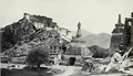
Lhasa's (western gate)- the Tibetans called this chorten, Pargo Kaling pictured here at the time of the 1904 British expedition to Tibet.
See also
 In Spanish: Chengguan (Lhasa) para niños
