
Lhasa (city) facts for kids
Quick facts for kids
Lhasa
ལྷ་ས་གྲོང་ཁྱེར།
拉萨市 |
|
|---|---|
|
Prefecture-level city
|
|

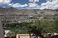
View of Lhasa from Potala Palace
|
|
.png)
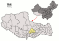
Location of Lhasa prefecture-level city jurisdiction in the Tibet Autonomous Region
|
|
| Country | China |
| Autonomous region | Tibet |
| Municipal seat | Chengguan District |
| Government | |
| • Type | Prefecture-level city |
| • Body | Lhasa Municipal People's Congress |
| Area | |
| • Prefecture-level city | 29,274 km2 (11,303 sq mi) |
| • Urban | 53 km2 (20 sq mi) |
| Elevation | 4,150 m (13,620 ft) |
| Population
(2020 Census)
|
|
| • Prefecture-level city | 867,900 |
| • Density | 29.6475/km2 (76.787/sq mi) |
| GDP | |
| • Total | CN¥ 74.2 billion US$ 11.5 billion |
| • Per capita | CN¥ 85,000 US$ 13,100 |
| Time zone | UTC+8 (China Standard) |
| Area code(s) | 891 |
| ISO 3166 code | CN-XZ-01 |
| Licence plate prefixes | 藏A |
| Lhasa | |||||||||||||||
|---|---|---|---|---|---|---|---|---|---|---|---|---|---|---|---|
.svg)
"Lhasa" in Simplified Chinese characters (top), Traditional Chinese characters (middle), and Tibetan script (bottom)
|
|||||||||||||||
| Chinese name | |||||||||||||||
| Simplified Chinese | 拉萨 | ||||||||||||||
| Traditional Chinese | 拉薩 | ||||||||||||||
| Hanyu Pinyin | Lāsà | ||||||||||||||
| Literal meaning | (Tibetan) "Place of the Gods" | ||||||||||||||
|
|||||||||||||||
| Also known as | |||||||||||||||
| Simplified Chinese | 逻些 | ||||||||||||||
| Traditional Chinese | 邏些 | ||||||||||||||
| Hanyu Pinyin | Luóxiē | ||||||||||||||
|
|||||||||||||||
| Tibetan name | |||||||||||||||
| Tibetan | ལྷ་ས་ | ||||||||||||||
|
|||||||||||||||
Lhasa is a special city in Tibet Autonomous Region, China. It's like a big county or district. Its name means "Place of the Gods" or "God's Home." Lhasa covers a large area of mountains and valleys, about 29,274 square kilometers. The main city area, called Chengguan District, has about 300,000 people.
Lhasa is located in the basin of the Lhasa River, a big river that flows into the Yarlung Tsangpo River. The land here is very high up and has many faults, which means earthquakes can happen. Summers are generally warm, and winters have sunny days that are above freezing. Most of the rain falls in summer.
People in the higher areas use the land for grazing animals like yaks, sheep, and goats. In the river valleys, farmers grow crops like barley, wheat, and vegetables. You might spot rare animals like the snow leopard and black-necked crane here. Some mining has caused environmental issues.
In 2020, the total population of Lhasa was about 867,900 people. Most of these are ethnic Tibetans. Lhasa is connected by two major highways and the Qinghai–Tibet railway. Another railway, the Sichuan–Tibet railway, is being built and should open around 2030. Large dams on the Lhasa River provide electricity. Lhasa has primary schools and basic medical care, but more advanced facilities are still needed. Tibetan Buddhism has been a very important part of the local culture since the 7th century. Many monasteries were damaged in the past but have been rebuilt and are now popular tourist spots.
Contents
History of Lhasa
Lhasa is the capital and largest city in Tibet. It was founded around the 5th century AD. For a long time, it was mostly closed to visitors until the early 1980s. It is a holy Buddhist city, famous for the Potala Palace, which used to be the home of the Dalai Lama. You can also see many prayer wheels and colorful prayer flags around the city.
In 645, forces from the Tang dynasty in China entered Tibet. Over the centuries, there were conflicts, including Mongol invasions and a period when Tibet was under the rule of the Qing dynasty. In 1912, after the Qing dynasty fell, Tibet became independent. The Thubten Gyatso was a key leader during this time.
After World War II ended in 1945, Mao Zedong and the Chinese Communist Party won the Chinese Civil War. In 1949, Mao Zedong announced the creation of the People's Republic of China. Tibet later became part of the People's Republic of China. In 1959, during the Tibetan uprising, the 14th Dalai Lama left Tibet and went to India.
Geography of Lhasa
Where is Lhasa Located?
Lhasa is in the south-central part of Tibet, just north of the Himalayas mountains. The city area stretches about 277 kilometers from east to west and 202 kilometers from north to south. It covers a total area of 29,518 square kilometers.
Lhasa is surrounded by other cities and regions:
- Nagqu City to the north
- Nyingchi City to the east
- Shannan/Lhoka City to the south
- Xigazê City to the west
The city is mainly located in the basin of the Lhasa River. This river valley is very important for Tibet's politics, economy, and culture. The central part of Lhasa, Chengguan District, is a hub for transportation, communication, education, and religion. It's also a major tourist spot with famous places like the Potala Palace, Jokhang, and Ramoche Temple.
The Lhasa River Basin
.jpg)
The Lhasa River basin is where most of Lhasa city is located. The Lhasa River is a big branch of the Yarlung Tsangpo River. Some parts of the region, like northern Damxung County, go beyond this basin and include part of the Namtso lake. Namtso is the second-largest salt lake in China, known for its beautiful blue waters.
The Lhasa River basin has an average height of about 4,500 meters above sea level. The ground here is very active, meaning earthquakes happen often. The river gets most of its water from summer monsoon rains, which fall from July to September. This can cause floods during these months. In winter, the river water levels are low, and it sometimes freezes.
The Lhasa River starts where three smaller rivers meet. These rivers flow from high mountains, some as high as 5,290 meters. In its upper parts, the river flows through a deep valley. Further down, the valley becomes flatter, and the river gets wider, about 150 to 200 meters across. The river's water quality is good because there isn't much pollution from sewage or farm chemicals.
Big power stations like Zhikong Hydro Power Station and Pangduo Hydro Power Station use the river's water to create electricity.
Climate and Environment
Lhasa's Weather Patterns

Lhasa is at a high altitude, around 3,610 meters or more. This makes it cooler than places at the same latitude in other parts of the world. The river valleys in central Tibet are warm in summer. Even in the coldest winter months, the temperature stays above freezing on sunny days.
Lhasa has a semi-dry monsoon climate. The average temperature is between 1.2 and 7.5°C. About 85% of the annual rainfall, which is around 466.3 mm, happens from June to September. Lhasa also gets a lot of sunshine, typically 3,000 hours each year. Northern areas are colder, while southern areas are warmer.
Nature and Wildlife

Most people in Tibet live in the southern valleys, including those around Lhasa. Higher up, nomadic people called drokpa herd yaks, sheep, and goats on the grasslands. In the lower valleys, farmers grow crops like barley, wheat, and various vegetables. The traditional main food is tsampa, which is barley flour often mixed with buttered tea.
In 1889, a visitor described the Lhasa valley as very fertile. It was watered by the Kyi River and other streams, with fields of buckwheat, barley, and peas. There were also groves of poplar and willow trees, making it look like a park.

The Lhasa region doesn't have a huge variety of wildlife, but the Lhasa valley is home to hundreds of black-necked cranes in winter. These endangered cranes migrate to Tibet every winter and can be seen around the Hutoushan Reservoir and other areas. Other animals found here include bharal (blue sheep), pheasants, roe deer, Thorold's deer, Mongolian gazelle, Siberian ibex, otters, brown bears, snow leopards, and ducks. Many medicinal plants also grow here.
Some mining in the mountains has turned green pastures into grey areas. The government is working on replanting programs to help the environment. A study in 2015 found high levels of arsenic in the Duilong River, likely from untreated water from a geothermal power station.
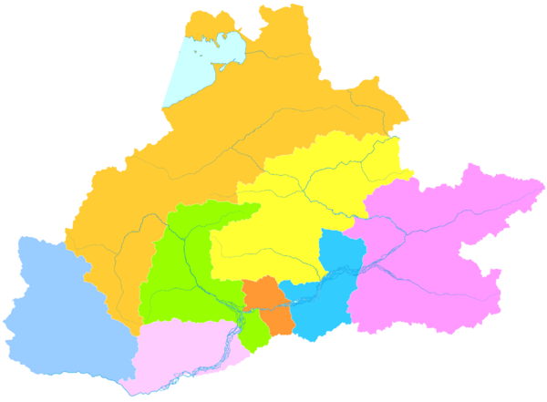
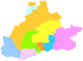
Administrative Divisions
Lhasa is divided into three districts and five counties. The districts of Chengguan, Doilungdêqên, and Dagzê contain most of the urban area of Lhasa. The other five counties are mostly rural.
| Map | |||||||
|---|---|---|---|---|---|---|---|
Doilungdêqên
Dagzê
Damxung
County Qüxü
County Nyêmo
County Lhünzhub
County Maizhokunggar
County Liuwu
Lake
Nam |
|||||||
| Name | Chinese | Hanyu Pinyin | Tibetan | Wylie Tibetan pinyin |
Population (2010) | Area (km2) | Density (/km2) |
| City Proper | |||||||
| Chengguan District | 城关区 | Chéngguān Qū | ཁྲིན་ཀོན་ཆུས། | khrin kon chus Chingoin Qü |
279,074 | 525 | 531.56 |
| Suburban | |||||||
| Doilungdêqên District | 堆龙德庆区 | Duīlóngdéqìng Qū | སྟོད་ལུང་བདེ་ཆེན་ཆུས། | stod lung bde chen chus Dölungdêqên Qü |
52,249 | 2,672 | 19.55 |
| Dagzê District | 达孜区 | Dázī Qū | སྟག་རྩེ་ཆུས། | stag rtse chus Dagzê Qü |
26,708 | 1,361 | 19.62 |
| Rural | |||||||
| Damxung County | 当雄县 | Dāngxióng Xiàn | འདམ་གཞུང་རྫོང་ | dam gzhung rdzong Damxung Zong |
46,463 | 10,234 | 4.54 |
| Lhünzhub County | 林周县 | Línzhōu Xiàn | ལྷུན་གྲུབ་རྫོང་ | lhun grub rdzong Lhünzhub Zong |
50,246 | 4,100 | 12.25 |
| Maizhokunggar County | 墨竹工卡县 | Mòzhúgōngkǎ Xiàn | མལ་གྲོ་གུང་དཀར་རྫོང་ | mal gro gung dkar rdzong Maizhokunggar Zong |
44,674 | 5,492 | 8.13 |
| Nyêmo County | 尼木县 | Nímù Xiàn | སྙེ་མོ་རྫོང་ | snye mo rdzong Nyêmo Zong |
28,149 | 3,266 | 8.61 |
| Qüxü County | 曲水县 | Qūshuǐ Xiàn | ཆུ་ཤུར་རྫོང་ | chu shur rdzong Qüxü Zong |
31,860 | 1,624 | 19.61 |
Chengguan District: Lhasa's Heart

.JPG)
Chengguan District is the main urban area of Lhasa. It's located along the middle part of the Lhasa River. The land here rises up to the north and south of the river. This district is about 28 kilometers from east to west and 31 kilometers from north to south. It covers an area of 525 square kilometers.
Chengguan District is bordered by Doilungdêqên District to the west, Dagzê District to the east, and Lhünzhub County to the north. To the south is Gonggar County. The district is about 3,650 meters above sea level. The average temperature is 8°C, and most rain falls between July and September.
Before 1951, the city of Lhasa had about 25,000 to 30,000 people. If you included the large monasteries nearby, the population was around 45,000 to 50,000. The old city was centered around the Jokhang temple. By 1990, Lhasa had grown to cover 40 square kilometers with an official population of 160,000. In 2013, the urban area filled most of the Lhasa River valley in Chengguan District.
Doilungdêqên District: Western Expansion
.jpg)
Doilungdêqên District is where the western urban areas of Lhasa have grown in recent years. This is also where the new Lhasa railway station is located, about 12 kilometers from the city center. The district covers 2,704 square kilometers.
The district borders the northern Tibet grasslands. The Duilong River flows south through the district to the Lhasa River. The average height of the district is 4,000 meters, with the highest point at 5,500 meters and the lowest at 3,640 meters.
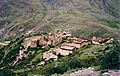
Doilungdêqên has about 120 days without frost each year. The average temperature is 7°C. It gets about 440 mm of rain annually. This district is very good for farming and used to provide food for Lhasa's kings. The main town is Donggar, which is only 14 kilometers from downtown Lhasa. Most people here are ethnic Tibetan and work in farming. The district also has minerals like coal and iron. The historic Tsurphu Monastery, built in 1189, is located here.
Dagzê District: Eastern Growth
Dagzê District covers 1,373 square kilometers and includes the eastern urban areas of Lhasa. Its average height is 4,100 meters above sea level, going down to 3,730 meters in the Lhasa River valley. The average temperature is 7.5°C, with about 130 frost-free days. Most of the 450 mm of rain falls in the summer.
As of 2013, Dagzê District had a population of 29,152. Most people work in agriculture. The Sichuan-Tibet Highway (China National Highway 318) passes through the district. Important monasteries like Ganden Monastery and Yerpa are found in Dagzê.
Damxung County: Northern Highlands


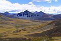
Damxung County is a large area of 10,036 square kilometers with rugged mountains. In 2013, its population was about 40,000. Earthquakes are common here. In the northeast, Namtso lake covers 1,920 square kilometers, with 45% of it in Damxung. The Nyenchen Tanglha Mountains run along the northwest, with Mount Nyenchen Tanglha being the highest peak at 7,111 meters.
Damxung has cold, dry winters and cool, wet summers. The average temperature is 1.3°C, with only 62 frost-free days. The ground is frozen from November to March. Most people raise livestock like yaks, sheep, goats, and horses. The Qinghai-Tibet Highway (China National Highway 109) and the Qinghai–Tibet Railway both cross the county. The Yangbajain Geothermal Field provides electricity to Lhasa using heat from the earth.
Lhünzhub County: Northeast Valleys

Lhünzhub County is about 65 kilometers northeast of Lhasa. It includes the Pengbo River Valley and the upper parts of the Lhasa River. The county is geologically complex and has an average height of 4,000 meters. The main town is Lhünzhub.
In 2000, the county had about 50,895 people. The southern Pengbo valley has a milder climate and is the main area for growing grains like barley and wheat. The northern part is mountainous and mostly used for grazing yaks, sheep, and goats. Pottery making is a long-standing tradition here. Mining is also an important part of the economy. The Pangduo Hydro Power Station started working in 2014. Lhünzhub County is also a center for Tibetan Buddhism, with many monasteries and nunneries.
Maizhokunggar County: Eastern Mountains


Maizhokunggar County is located in the middle and upper parts of the Lhasa River area. It's about 68 kilometers east of Lhasa and covers 5,492 square kilometers. The average height is over 4,000 meters. The average temperature is between 5.1 and 9.1°C, with about 90 frost-free days. The China National Highway 318 runs through the county. The Zhikong Hydro Power Station on the Lhasa River provides electricity.
Most of the 48,561 people in Maizhokunggar County are ethnic Tibetan and work in farming and herding. They grow various crops and raise animals. Mining is a big part of the local economy. The county is known for its traditional pottery, which has a history of over 1,000 years. The Drikhung Thil Monastery, a famous Buddhist site, is also located here.
Nyêmo County: Southern Agriculture
Nyêmo County is in the middle section of the Brahmaputra River area, about 140 kilometers from Lhasa. It's mainly an agricultural and pastoral region, covering 3,276 square kilometers. The average height is 4,000 meters. The Nimu Maqu River flows through the county, and the Yarlung Tsangpo River forms its southern border.
Nyêmo has a temperate, semi-dry climate with about 100 frost-free days. The annual rainfall is 324.2 mm. The county headquarters are in Nyêmo Town. As of 2011, most of the 30,844 people worked in farming or herding. Nyêmo has a long history of making paper and printing texts using woodblocks, dating back to the 7th century. It even has China's first museum dedicated to Tibetan texts.
Qüxü County: River Confluence

Qüxü County has a total area of 1,680 square kilometers and an average height of 3,650 meters. It's located in the Yarlung Tsangpo valley, which is mostly flat but rises to the Nyainqêntanglha Mountains in the north. The Lhasa River flows through the eastern part of the county to meet the Yarlung Tsangpo River, which forms the county's southern border.
Qüxü County has about 150 frost-free days each year. The annual rainfall is 441.9 mm. The county headquarters are in Qüxü Town. The China National Highway 318 passes through the county. Qüxü is a farming area, growing crops like barley, wheat, and peas, as well as apples and walnuts. Animal farming is also important. The Nyethang Drolma Lhakhang Temple is located here.
Demographics: Who Lives in Lhasa?
The population of Lhasa is a mix of different groups. According to the 2020 census, Lhasa has about 867,891 people. About 16.9% are ethnic Han Chinese, and most of the rest are ethnic Tibetans. Many people live in the city and towns, especially near Chengguan District, while others live in rural areas.
Ethnic Groups in Lhasa

The 2000 census showed the following breakdown of ethnic groups in Lhasa:
| Major ethnic groups in Lhasa Prefecture-level City by district or county, 2000 census | |||||||
|---|---|---|---|---|---|---|---|
| Total | Tibetans | Han Chinese | others | ||||
| Chengguan District | 223,001 | 140,387 | 63.0% | 76,581 | 34.3% | 6,033 | 2.7% |
| Doilungdêqên District | 40,543 | 38,455 | 94.8% | 1,868 | 4.6% | 220 | 0.5% |
| Dagzê District | 24,906 | 24,662 | 99.0% | 212 | 0.9% | 32 | 0.1% |
| Damxung County | 39,169 | 38,689 | 98.8% | 347 | 0.9% | 133 | 0.3% |
| Lhünzhub County | 50,895 | 50,335 | 98.9% | 419 | 0.8% | 141 | 0.3% |
| Maizhokunggar County | 38,920 | 38,567 | 99.1% | 220 | 0.6% | 133 | 0.3% |
| Nyêmo County | 27,375 | 27,138 | 99.1% | 191 | 0.7% | 46 | 0.2% |
| Qüxü County | 29,690 | 28,891 | 97.3% | 746 | 2.5% | 53 | 0.2% |
| Total | 474,499 | 387,124 | 81.6% | 80,584 | 17.0% | 6,791 | 1.4% |


Many Han Chinese people who live in Lhasa are registered elsewhere. They often work in construction, mining, and trade. In rural areas outside Chengguan District, the Han population is very small.
Education in Lhasa
Lhasa has several important schools for higher education. These include two universities, Tibet University and Tibet Tibetan Medical University. There are also three special colleges: Lhasa Teachers College, Tibet Police College, and Tibet Vocational and Technical College.
Tibet University is the main university in the Tibet Autonomous Region. Its campus is in Chengguan District. The university started in 1985 with funding from the Chinese government. About 8,000 students attend Tibet University, which offers a wide range of subjects. It is known for its high academic standards in the region.
Infrastructure and Services
Roads and Highways

Lhasa is well-connected by roads. China National Highway 318 enters Lhasa from the east at Mila Mountain, which is 5,000 meters high. This highway runs through several counties, including Maizhokunggar County and Dagzê District. It also goes through the center of Lhasa city.
.jpg)
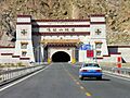
China National Highway 109 (the Qinghai–Tibet Highway) comes from the northeast through Damxung County. It then joins Highway 318 just west of Lhasa. The Lhasa Airport Expressway connects Lhasa to Lhasa Gonggar Airport. This four-lane expressway was the first of its kind in the Tibet Autonomous Region.
Railways Connecting Lhasa

The Qinghai–Tibet Railway runs through Lhasa, following the same path as the Qinghai–Tibet Highway. It ends at Lhasa railway station in Niu New Area. This station is over 3,600 meters above sea level and is the largest passenger station on the line. It even has a clinic with oxygen for passengers. The station uses solar energy for heating.
The Liuwu Bridge connects central Lhasa to the railway station. Another railway, the Sichuan–Tibet Railway, is being built. It will connect Chengdu (the capital of Sichuan) to Lhasa. This new line will be 1,629 kilometers long and will cut travel time from 48 hours to just 13 hours.
Power and Electricity

The Yangbajain Geothermal Station was built in 1977 in Damxung. It uses heat from the earth to create electricity. It was the first geothermal power station in Tibet and is the largest in China. It started providing electricity to Lhasa in 1981. It was Lhasa's main power source until the Yamdrok Hydropower Station began operating. Today, it provides 25,181 kilowatts of power to Lhasa.
The Pangduo Hydro Power Station is on the Lhasa River in Lhünzhub County. It's sometimes called "Tibet's Three Gorges Dam." It holds back 1.17 billion cubic meters of water and can generate 160 megawatts of electricity. The Zhikong Hydro Power Station is also on the Lhasa River, about 100 kilometers northeast of Lhasa. It's a 50-meter-tall dam that can generate 100 megawatts of power.
Other Important Facilities

Rural counties in Lhasa generally have many primary schools in villages, with good attendance. Most also have at least one secondary school. For example, Dagzê County had 28 schools in 2010. While Tibetan is the main language for teaching, some schools near Lhasa have started teaching in Chinese.
Many towns have small clinics, and most villages have a health station. Damxung County had seven hospitals in 2009. Maizhokunggar County has a special health care system that helps many people get coverage.
Lhasa has local television and radio stations. In Lhünzhub County, 72.1% of people can watch TV, and 83.4% can listen to the radio. Providing phone and internet services in the high-altitude terrain is expensive, but mobile phone and internet use have grown rapidly since 2005.
Temples and Monasteries

Buddhism became the official religion of Tibet in the 7th century under King Songtsän Gampo. Over time, Tibetan Buddhism became a huge part of people's lives. The first monastery, Samyé, was founded around 766.
Early Buddhist Foundations
Yerpa, in Dagze County, has ancient meditation caves linked to Songtsän Gampo. Some of these sites date back to before Buddhism came to Tibet. The Jokhang temple in Chengguan District is the most sacred temple in Tibet. It was built in the 7th century when Lhasa became the capital. It was built to house a special image of Buddha.
Ramoche Temple, north of Jokhang, is also very important and was built around the same time. Muru Nyingba Monastery is a smaller monastery in Lhasa. Many monasteries were damaged in the past but have been rebuilt.
Middle Period Monasteries

The Nyethang Drolma Temple is southwest of Lhasa. Some say it was built by Atiśa (980–1054) or his student Dromtön (1004–64). Dromtön also built Reting Monastery in Lhünzhub County in 1056. It was the first monastery of the Gedain sect.
Tsurphu Monastery in Doilungdêqên District was built in 1189. It is the main temple of the Karma Kagyu school of Buddhism. The Drigung Monastery in Maizhokunggar County was founded in 1179. It was once very powerful in both politics and religion. Yangpachen Monastery in Damxung County was built in 1490. It was the main monastery of the Red Hat school of the Karma Kagyu sect.
Gelug School Foundations

Ganden Monastery was built after 1409 by Je Tsongkhapa, who founded the Gelug sect. It is the most important monastery of this sect. It's about 57 kilometers from Lhasa on Wangbori Mountain. The monastery has Buddha halls, palaces, and Buddhist colleges.
Drepung Monastery in Chengguan District was founded in 1416. It was once the largest monastery in the world, with up to 10,000 monks. Sera Monastery, north of Lhasa, was founded in 1419. Ganden, Drepung, and Sera are known as the "Three Seats of Learning" for the Gelug school. Other Gelug monasteries include Nechung Monastery, Sanga Monastery, Ani Tsankhung Nunnery, Kundeling Monastery, and Tsomon Ling.
Restoration of Monasteries


Many monasteries in Lhasa were damaged or destroyed during the 1950s and the Cultural Revolution (1966–76). For example, Jokhang was used as a military barracks and later a hotel. Many statues were damaged or removed. However, most of these monasteries have been restored since the 1980s. Jokhang was named a UNESCO World Heritage Site in 2000.
Reting Monastery, Tsurphu Monastery, Drigung Monastery, Yangpachen Monastery, Ganden Monastery, and Nechung Monastery were all severely damaged but have been rebuilt. Today, these restored sites serve as important religious centers and tourist attractions.
Images for kids
-
View of Lhasa from Potala Palace
-
Location of Lhasa prefecture-level city jurisdiction in the Tibet Autonomous Region
-

"Lhasa" in Simplified Chinese characters (top), Traditional Chinese characters (middle), and Tibetan script (bottom)
-

Lhasa terrane approach to Qiangtang terrane
-
Map of Administrative Divisions of Lhasa
-

Young monk in meditation cell, Yerpa, Dagzê County, 1993
-
China National Highway 318 at Mila Mountain pass
-
Galashan Tunnel of Lhasa Airport Expressway
-
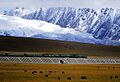
Railway in Damxung about 20 km north of Yangbajain
-
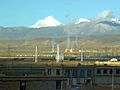
Yangbajain Geothermal Field
-
Yerpa ruins in 1993


See also
 In Spanish: Lhasa para niños
