
Himalayas facts for kids
Quick facts for kids The Himalayas |
|
|---|---|

The curved shape of the Himalayas, showing very tall peaks (called eight-thousanders), major rivers like the Indus and Ganges, and the surrounding plains and plateaus.
|
|
| Highest point | |
| Peak | Mount Everest (Nepal, China) |
| Elevation | 8,848.86 m (29,031.7 ft) |
| Dimensions | |
| Length | 2,400 km (1,500 mi) |
| Geography | |

Mount Everest and nearby peaks seen from the Tibetan Plateau. You can spot four of the world's highest mountains here: Makalu, Everest, Cho Oyu, and Lhotse.
|
|
| Countries | |
| Geology | |
| Orogeny | Alpine orogeny |
| Age of rock | Cretaceous to Cenozoic |
| Type of rock | |
The Himalayas, also known as Himalaya, is a giant mountain range in Asia. It separates the flat lands of the Indian subcontinent from the high Tibetan Plateau. This amazing range is home to some of the Earth's tallest peaks, including Mount Everest, which is the highest mountain in the world! More than 100 peaks in the Himalayas are taller than 7,200 meters (about 23,600 feet) above sea level.
The Himalayas stretch across or touch five different countries: Nepal, India, China, Bhutan, and Pakistan. Some parts of the mountains in the Kashmir region are shared or debated among India, Pakistan, and China. To the northwest, the Himalayas meet the Karakoram and Hindu Kush mountains. To the north is the vast Tibetan Plateau, and to the south are the wide Indo-Gangetic Plains.
Many of the world's most important rivers, like the Indus, the Ganges, and the Tsangpo–Brahmaputra, start in or near the Himalayas. These rivers provide water for over 600 million people! About 53 million people actually live within the Himalayan mountains. The Himalayas have deeply influenced the cultures of South Asia and Tibet. Many of its peaks are considered sacred in Hinduism and Buddhism. Some summits, like Kangchenjunga, Gangkhar Puensum, Machapuchare, Nanda Devi, and Kailash, are even off-limits to climbers because they are so special.
The Himalayas were formed when two huge pieces of the Earth's crust, called the Indian tectonic plate and the Eurasian plate, slowly crashed into each other. This collision pushed the land upwards, creating these massive mountains. The Himalayan mountain range forms a long curve, about 2,400 kilometers (1,500 miles) long, running from west to east. Its western end is near Nanga Parbat, and its eastern end is near Namcha Barwa. The range is wider in the west (about 350 km or 217 miles) and narrower in the east (about 151 km or 94 miles).
Contents
- The Name: "Abode of Snow"
- Exploring the Himalayas: Mountains and Valleys
- How the Himalayas Were Formed: A Giant Collision
- Water from the Mountains: Rivers, Glaciers, and Lakes
- Himalayan Weather: A Mix of Extremes
- Himalayan Life: Plants and Animals
- Religions and Culture in the Himalayas
- Natural Resources
- See also
- Images for kids
The Name: "Abode of Snow"
The name Himalaya comes from an ancient Indian language called Sanskrit. It means "abode of snow." This name is made of two words: hima, meaning 'snow' or 'cold', and ālaya, meaning 'dwelling' or 'house'. It's a perfect name for mountains covered in snow!
Many languages use similar names for these mountains. For example:
In old stories, like the Hindu epic Mahabharata, the Himalayas are sometimes called Himavan. This name refers to a Hindu god who is like the spirit of the mountains. Other old names include Himaraja, meaning 'king of snow', and Parvateshwara, meaning 'lord of mountains'.
Exploring the Himalayas: Mountains and Valleys
The Himalayas are made up of four main mountain ranges that run side-by-side from south to north. These are:
- The Sivalik Hills in the south, which are the lowest hills.
- The Lower Himalayan Range, a bit taller.
- The Great Himalayas, which is the highest and central part, home to the tallest peaks.
- The Tibetan Himalayas in the north.
The Karakoram mountains are usually seen as a separate range, even though they are nearby.

In the middle of the Himalayas' big curve, you'll find incredibly tall peaks like Dhaulagiri and Annapurna in Nepal. These mountains are over 8,000 meters (about 26,000 feet) high! They are separated by a deep cut in the Earth called the Kali Gandaki Gorge. This gorge divides the Himalayas into western and eastern parts. The lowest point on the ridge between Mount Everest and K2 (the highest peak in the Karakoram) is at the top of this gorge.
East of Annapurna, you'll find other 8,000-meter peaks like Manaslu and Shishapangma (in Tibet). South of these mountains is Kathmandu, the capital of Nepal and the largest city in the Himalayas. Further east is the Mahalangur Himal region, which has four of the world's six highest mountains: Cho Oyu, Everest, Lhotse, and Makalu. The Khumbu region, famous for trekking, is also here, leading up to Everest.


In eastern Nepal, the Himalayas reach the Kangchenjunga massif, on the border with India. This is the third-highest mountain in the world and the highest point in India. The Indian state of Sikkim is on the eastern side of Kangchenjunga. East of Sikkim is the ancient kingdom of Bhutan, home to Gangkhar Puensum, possibly the highest unclimbed mountain in the world. Here, the mountains become very rugged with steep, forested valleys. The Himalayas then turn northeast through Arunachal Pradesh (India) and Tibet, ending near Namche Barwa in Tibet, where the Yarlung Tsangpo River makes a big bend.

Moving west from Dhaulagiri, western Nepal is more remote. It has Rara Lake, Nepal's largest lake. Further west, in Uttarakhand (India), you find the Kumaon and Garhwal Himalayas, with high peaks like Nanda Devi and Kamet. This state also has important pilgrimage sites like Gangotri (source of the holy Ganges river) and Yamunotri (source of the Yamuna river).
The Indian state of Himachal Pradesh is known for its hill stations like Shimla. Further west, the Himalayas form much of the Jammu and Kashmir region, with the beautiful Kashmir Valley. The twin peaks of Nun Kun are the only mountains over 7,000 meters (about 23,000 feet) in this area. Finally, the Himalayas end dramatically at Nanga Parbat, an 8,000-meter peak that rises high above the Indus valley. This western end is where the Himalayas meet the Karakoram and Hindu Kush ranges in Gilgit-Baltistan (Pakistan). Some parts of the Himalayas also extend into other Pakistani provinces.
How the Himalayas Were Formed: A Giant Collision
The Himalayas are still growing today! This amazing growth is due to how the Earth's crust works. Our planet's outer layer is broken into huge pieces called tectonic plates. These plates are always moving, very slowly, like giant rafts on the Earth's soft inner layers.
About 70 million years ago, a long time before you were born, the Indian tectonic plate started moving north. It was once part of a supercontinent called Gondwana. As it moved, it carried an ocean plate with it. Eventually, this Indian plate crashed into the Eurasian plate, which is where Europe and Asia are today.

When the two plates collided, the ocean plate slid underneath the Eurasian plate. But the Indian continental plate was too thick and strong to slide under easily. Instead, it pushed hard against the Eurasian plate. This immense pressure caused the Earth's crust to fold, buckle, and pile up, like a giant rug being pushed against a wall. This is how the towering Himalayan mountains were born!
Imagine pushing two thick books together. The pages in the middle would crumple and rise. That's similar to what happened with the Earth's crust. The rocks that now form the Himalayas were once at the bottom of an ancient ocean or deep within the Earth's crust. They were pushed up over millions of years.
This collision also pushed up the land to the north, creating the high Tibetan Plateau. The Indian plate is still pushing into Asia today, moving about 67 millimeters (about 2.6 inches) every year. This ongoing pressure means the Himalayas are still rising by about 5 millimeters (about 0.2 inches) each year! This constant movement also causes earthquakes in the region from time to time.

The Himalayas are made of different types of rock. The higher parts have sedimentary rocks, like limestone, which formed from ancient ocean sediments. Below these are metamorphic rocks, which changed due to intense heat and pressure. The lowest hills, called the Siwaliks, are made of sandstone, shale, and conglomerate rocks. These formed from the sediments washed down from the rising Himalayas.
Water from the Mountains: Rivers, Glaciers, and Lakes
Even though the Himalayas are huge, many rivers cut through them, especially in the eastern parts. These rivers collect water from the mountains and flow into two massive river systems:
The Indus River Basin
The western rivers combine to form the Indus Basin. The Indus River itself starts in Tibet and flows northwest through India into Pakistan. It then turns southwest to reach the Arabian Sea. Many important rivers, like the Jhelum, Chenab, Ravi, Beas, and Sutlej rivers, feed into the Indus. These five rivers give the Punjab region its name.

The Ganges-Brahmaputra Basin
Other Himalayan rivers drain into the Ganges-Brahmaputra Basin. Its main rivers are the Ganges, the Brahmaputra, and the Yamuna. The Brahmaputra starts as the Yarlung Tsangpo River in western Tibet. It flows east through Tibet and then west through the plains of Assam. The Ganges and Brahmaputra rivers meet in Bangladesh. They then flow into the Bay of Bengal through the world's largest river delta, the Sunderbans.

Glaciers: The "Third Pole"
The Himalayas hold the third-largest amount of ice and snow in the world, after Antarctica and the Arctic. Some people even call this region the "Third Pole." There are about 15,000 glaciers in the Himalayas. These glaciers store a huge amount of fresh water, about 12,000 cubic kilometers (2,900 cubic miles)! Famous glaciers include the Gangotri and Yamunotri in India, and the Khumbu near Mount Everest.
.jpg)
Because the Himalayas are so high, their permanent snow line is one of the highest on Earth, usually around 5,500 meters (about 18,000 feet). This means the highest parts of the mountains are covered in snow all year round. These snowy areas are where many large, year-round rivers begin.
However, scientists have noticed that glaciers in the Himalayas are melting faster in recent years. This is due to climate change. This melting could affect the water supply for hundreds of millions of people who rely on these rivers, especially during dry seasons.
Lakes: Mountain Gems
The Himalayan region has hundreds of beautiful lakes. Pangong Tso, which crosses the border between India and China in Tibet, is one of the largest, covering about 700 square kilometers (270 square miles).
.jpg)
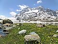
South of the main mountain range, the lakes are smaller. Tilicho Lake in Nepal is one of the highest lakes in the world. Other notable lakes include Rara Lake and She-Phoksundo Lake in Nepal, and Gurudongmar Lake and Lake Tsongmo in Sikkim, India.
Some of these lakes, formed by melting glaciers, can sometimes cause a danger called a glacial lake outburst flood. This happens if the natural dam holding back the lake breaks, releasing a lot of water very quickly. Scientists monitor lakes like Tsho Rolpa in Nepal, which has grown significantly due to melting glaciers.
Himalayan Weather: A Mix of Extremes
The weather in the Himalayas is very diverse. It depends on how high you are, how far north or south you are, and the powerful Southwest monsoon. The mountains stretch across many different climate zones, from warm subtropical areas at the base to freezing, snowy conditions at the highest peaks.

The Himalayas act like a giant wall, blocking cold, dry winds from Central Asia from blowing into South Asia. This keeps South Asia much warmer than other places at the same latitude. Temperatures in the Himalayas drop by about 2.0 degrees Celsius (3.6 degrees Fahrenheit) for every 300 meters (about 1,000 feet) you go up.
Mountains have very irregular shapes, so the weather can change a lot over short distances. The temperature also depends on the season and which way a mountain face is pointing towards the sun. The huge size of the Himalayas means that many peaks can even create their own unique weather patterns!
Rain and Snow: The Monsoon's Influence
The Southwest Monsoon has a huge impact on the Himalayan climate. This is a strong wind that brings heavy rain from June to September. In winter, high pressure over Central Asia brings dry winds. But in summer, the land heats up more than the ocean, creating low pressure. This pulls moist air from the Indian Ocean inland. When this moist air hits the mountains, it rises, cools, and releases its moisture as rain. This is called the orographic effect.

The monsoon can cause heavy rainfall, especially in the eastern Himalayas. For example, Darjeeling in the east gets about 2,030 millimeters (80 inches) of rain during monsoon season, while Shimla in the west gets about 975 millimeters (38 inches). This heavy rain can sometimes cause landslides and makes travel difficult.
Climate Zones
The lower parts of the Himalayas, including the Kathmandu Valley, have a humid subtropical climate. This means they have warm, wet summers and dry, mild winters. Higher up, most of the Himalayas have a subtropical highland climate.
The northern side of the Himalayas, also known as the Tibetan Himalaya, is very different. It's dry, cold, and often windy, with a cold desert climate. Here, there's not much plant life, and winters are extremely cold. Most of the precipitation comes as snow in late winter and spring.

.jpg)
Local features also affect the climate. Mountain slopes facing the wind get more rain, while areas in the "rain shadow" of large mountains get much less. For example, Upper Mustang is very dry because it's sheltered by the Annapurna and Dhaulagiri mountains, while Pokhara on the other side gets a lot of rain.
Himalayan Life: Plants and Animals
The plants and animals in the Himalayas change a lot depending on the climate, rainfall, altitude, and soil. The climate ranges from tropical at the base of the mountains to permanent ice and snow at the highest elevations. This wide variety of conditions supports many different kinds of plant and animal communities.
At very high altitudes, the rare and beautiful snow leopard is the top hunter. It preys on animals like the bharal, or Himalayan blue sheep, which graze on the alpine pastures. The Himalayan musk deer, hunted for its musk, is also found high up but is now endangered. Other unique herbivores include the Himalayan tahr, the takin, the Himalayan serow, and the Himalayan goral.
The critically endangered Himalayan brown bear lives in some parts of the range, as does the Asian black bear. In the eastern Himalayas, red pandas live in bamboo forests. Lower down, the forests are home to different types of monkeys, like the endangered Gee's golden langur and the Kashmir gray langur.


.jpg)


_(46511242922).jpg)

The unique plants and animals of the Himalayas are changing because of climate change. Rising temperatures are causing some species to move to higher elevations. For example, pine forests are starting to grow in areas where oak forests used to be. Some trees, like rhododendrons, are also flowering and fruiting earlier than before. The highest known tree species in the Himalayas is Juniperus tibetica, found at 4,900 meters (about 16,000 feet) in Tibet.
Religions and Culture in the Himalayas
The Himalayas are very important in many cultures and religions.
.jpg)
Sacred Places
In Jainism, Mount Ashtapada in the Himalayas is a holy place where the first Jain spiritual leader, Rishabhanatha, found enlightenment. For Hindus, the Himalayas are seen as a god, Himavat, the king of all mountains and father of the goddess Parvati. The goddess Ganga (the spirit of the Ganges river) is also considered his daughter. Two very sacred Hindu pilgrimage sites are the Pashupatinath complex and Muktinath in Nepal.

Buddhists also hold the Himalayas in high regard. The Paro Taktsang monastery in Bhutan is where Buddhism began in that country. Muktinath is also a pilgrimage site for Tibetan Buddhists. They believe that the trees in a nearby grove grew from the walking sticks of ancient Buddhist magicians. Many Vajrayana Buddhist sites are found across the Himalayas in Tibet, Bhutan, and parts of India like Ladakh and Sikkim. Tibet alone once had over 6,000 monasteries.
Diverse People and Traditions
The people living in the Himalayas are very diverse. This can be seen in their homes, which are built to suit their practical needs and beliefs. Their languages, dialects, beliefs, and clothing also show this rich variety. For example, handwoven textiles often have colors and patterns unique to different ethnic groups. Jewelry is also important to some, with Rai and Limbu women wearing large gold earrings and nose rings to display their wealth.
Natural Resources
The Himalayan forests are a treasure trove of medicinal plants. For thousands of years, people have used these plants to treat various illnesses, from simple coughs to snake bites. Different parts of the plants—roots, flowers, stems, leaves, and bark—are used as remedies. For instance, bark from an Abies pindrow tree helps with coughs. A paste from Andrachne cordifolia leaves and stems is used for wounds and as an antidote for snake bites.
Many people in Asian and African countries rely on these medicinal plants for their health. Because so many depend on them, these plants are an important source of income for local communities. This helps with economic development in and around the region. However, people sometimes cut down trees for wood, which can harm the forests if not done carefully.
See also
 In Spanish: Himalaya para niños
- Eastern and Western Himalaya
- Indian Himalayan Region
- List of Himalayan peaks and passes
- List of Himalayan topics
- List of mountains in India, Pakistan, Bhutan, Nepal and China
- List of Ultras of the Himalayas
- Trekking peak
Images for kids
-
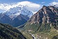
The Marsyangdi valley with Annapurna II in the background.
-
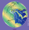
A map showing how ancient landmasses drifted north to eventually form parts of Asia.
-
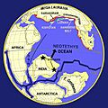
A geological map showing how different landmasses came together before India collided with Eurasia.
-
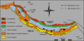
The Indus-Yarlung suture zone (in green) marks where the Indian plate joined with the Eurasian plate.
-
Layers of rock in the Himalayas that were folded by the pressure of the colliding continents.
-
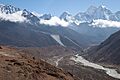
The Imja Khola river valley in the Solukhumbu region of Nepal.
-
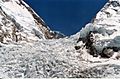
The Khumbu Icefall is a dangerous, moving river of ice on the way to Mount Everest.
-
The Gandaki River flowing through a valley in Nepal.
-
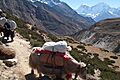
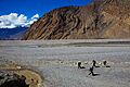
A caravan of yaks, which are used to carry goods in the high mountains.
-
The cold desert region of Upper Mustang in Nepal, which is in the rain shadow of the Annapurnas.
-
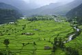
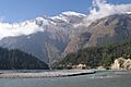
A village in the Pokhara Valley during the rainy monsoon season.
-
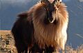
A male Himalayan tahr, a type of wild goat found in the Himalayas.
-
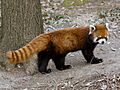
The Red panda lives in the bamboo forests of the eastern Himalayas.
-
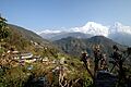
The village of Ghandruk in Nepal, with Annapurna South mountain in the background.
-
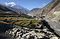
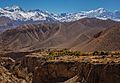
The village of Kagbeni in the dry, high-altitude region of Mustang, Nepal.
-
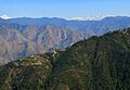
The Garhwal Himalayas in the Indian state of Uttarakhand.
-
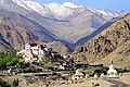
Likir Monastery in the Ladakh region of India.
-
Harmukh is a sacred mountain for Hindus in the Kashmir Valley.


.jpg)


