
Hindu Kush facts for kids

The Hindu Kush is a huge mountain range in Asia. It stretches across countries like Afghanistan and Pakistan. It's like a giant natural wall! One of its highest peaks is Tirich Mir. To the west, there's a narrow strip of land called the Wakhan Corridor. This corridor helps separate Afghanistan from Tajikistan. It was created a long time ago, around 1890, by agreements between the Russian and British Empires. They wanted a neutral area between their lands.
Contents
Exploring the Hindu Kush Mountains
The Hindu Kush mountains are very important because they have many natural pathways called passes. These passes connect different regions.
Mountain Passes
Several important mountain passes are found in the Hindu Kush range. These include the Mintaka Pass, Kilik Pass, Chilinji Pass, and Kuramber Pass. These passes have historically been used to connect Kashmir with countries in Central Asia. They were like ancient highways for trade and travel!
Rivers of the Hindu Kush
Many rivers start in the valleys of the Hindu Kush mountains. These rivers include the Chapursan River, Ishkuman River, Ghizar River, Gilgit River, and Shandur River. All these rivers eventually flow into the mighty Indus River, which is one of the longest rivers in Asia.
Images for kids
-

Hindu Kush (top right) and its extending mountain ranges like Selseleh-ye Safīd Kūh or Koh-i-Baba to the west
-

Aerial view of Hindu Kush mountains in northern Afghanistan
-
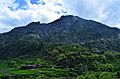
Terraced fields amongst the Hindu Kush in the Swat valley, Pakistan
-
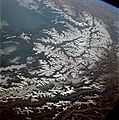
The Hindu Kush photographed by Apollo 9
-
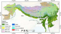
A land cover map of the HKH region was developed using Landsat 30-meter data.
-
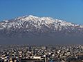
Kabul, situated 5,900 feet (1,800 m) above sea level in a narrow valley, wedged between the Hindu Kush mountains
-
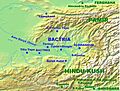
Hindu Kush relative to Bactria, Bamiyan, Kabul and Gandhara (bottom right).
-
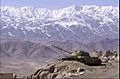
Landscape of Afghanistan with a T-62 in the foreground.
-
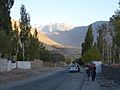
Hindu Kush in the background in Ishkoshim, Tajikistan


_(31895374700).jpg)
See also
 In Spanish: Hindú Kush para niños
