
Indus River facts for kids
Quick facts for kids Indus |
|
|---|---|

The Indus Gorge is formed as the Indus River bends around the Nanga Parbat massif, shown towering behind, defining the western anchor of the Himalayan mountain range.
|
|

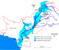
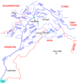
The course and major tributaries of the Indus river
|
|
| Other name(s) | Sindhu |
| Country | China, India, Pakistan |
| States or provinces | Tibet Autonomous Region, Ladakh, Gilgit-Baltistan, Khyber Pakhtunkhwa, Punjab, and Sindh |
| Cities | Leh, Skardu, Dasu, Besham, Thakot, Swabi, Dera Ismail Khan, Bhakkar, Sukkur, Hyderabad, Karachi |
| Physical characteristics | |
| Main source | Lake Manasarovar Tibetan Plateau |
| River mouth | Arabian Sea (primary), Rann of Kutch (secondary) Indus River Delta (primary), Pakistan Kori Creek (secondary), India 0 m (0 ft) 23°59′40″N 67°25′51″E / 23.99444°N 67.43083°E |
| Length | 3,180 km (1,980 mi) |
| Discharge (location 2) |
|
| Discharge (location 3) |
|
| Discharge (location 4) |
|
| Basin features | |
| Basin size | 1,120,000 km2 (430,000 sq mi) |
| Tributaries | |
The Indus River is a very long river in Asia. It flows through China, India, and Pakistan. It starts high in the Himalayas and flows for about 3,180 km (1,980 mi) before emptying into the Arabian Sea.
This river is super important for the people living along its banks. It provides water for farming and supports many cities. Thousands of years ago, a major ancient civilization, the Indus Valley Civilisation, grew up around this river.
Contents
River Name and History
Where the Name Comes From
The Indus River has been known by many names throughout history. Ancient Indians called it Sindhu in Sanskrit. The Persians called it Hindu. Both names meant "the border river."
The name India actually comes from the Indus River! Ancient Greeks called the river Indós, and the Romans later called it Indus. Over time, the name "India" was used for the entire region east of the river.
Other Names for the Indus
People in different regions have their own names for the river:
- In Ladakh and Tibet, it's called Senge Tsangpo, meaning "Lion's Mouth."
- Baltis call it Gemtsuh and Tsuh-Fo.
- Pashtuns call it Nilab, Sher Darya, and Abbasin.
- Sindhis call it Mehran, Purali, and Samundar.
- In modern Urdu and Hindi, it's called Sindh.
Ancient Civilizations and Empires

The Indus Valley Civilisation was one of the world's first major urban civilizations. It thrived around 3300 BCE. Its big cities, like Harappa and Mohenjo-daro, were some of the largest in the ancient world. This civilization stretched across parts of Afghanistan, Pakistan, and northwest India.
The river was mentioned in ancient texts like the Rigveda, which called it "Sindhu." This shows how important the river was to early cultures. Later, empires like the Persian Empire and the armies of Alexander the Great crossed the Indus. It served as a gateway to the Indian subcontinent for many groups throughout history.
River's Journey and Features

Where the River Starts
The Indus River begins in the high mountains of Tibet. Its main source is a spring called Sênggê Kanbab, or "Lion's Mouth," near the sacred Mount Kailash. Many other streams fed by melting snow and glaciers also join the river.
Its Path to the Sea
From its source, the Indus flows northwest through Ladakh (in India) and then into Gilgit-Baltistan (in Pakistan). Along its way, it collects water from other rivers like the Shyok River and Gilgit River.
The river then turns south and flows into the plains of Punjab in Pakistan. It passes through huge, deep gorges near the Nanga Parbat mountain. Near Attock, the Kabul River joins it.
As it reaches the plains of Punjab and Sindh, the river slows down and spreads out. It is joined by the Panjnad River at Mithankot. Finally, the Indus forms a large delta (a fan-shaped landform where a river splits into many smaller channels) before meeting the Arabian Sea in Pakistan.
Changing Course and Tides
The Indus is one of the few rivers in the world that experiences a tidal bore. This is a strong tide that forms a wave and travels up the river.
The river's flow changes with the seasons. It gets much smaller in winter but floods its banks during the monsoon rains from July to September. The Indus has also changed its course over time. For example, after an earthquake in 1816, it shifted westwards.
Importance to People and Economy

The Indus River is vital for Pakistan's economy. It provides most of the water for farming in the Punjab province, which is often called the "breadbasket" of the nation. The word Punjab means "land of five rivers," and these five rivers all flow into the Indus.
Irrigation and Water Management
Because rainfall is low in the lower Indus valley, irrigation is super important. People have been building canals to use the river's water for thousands of years. The British East India Company built a huge network of modern canals starting in 1850.
Today, Pakistan has one of the largest irrigation systems in the world, thanks to the Indus. Large dams and barrages (like the Tarbela Dam and Sukkur Barrage) help control the water. These projects provide water for crops like cotton, sugarcane, and wheat. They also generate electricity for homes and industries.
In 1960, India and Pakistan signed the Indus Waters Treaty. This agreement ensures that Pakistan receives water from the Indus and its two main tributaries, the Jhelum River and the Chenab River.
Wildlife of the Indus River

The Indus River and the land around it are home to many different animals. Long ago, there were thick forests and animals like rhinoceroses along the river. Today, much of the area is dry, but farming helps keep it green.
Unique Mammals
- Indus River Dolphin: This special dolphin (Platanista indicus minor) lives only in the Indus River. It's one of the most endangered cetaceans (a group that includes dolphins and whales). There are only about 1,800 left. They are threatened by dams, fishing nets, and pollution.
- Otters: Two types of otters live in the Indus basin. The Eurasian otter is in the highlands, and the smooth-coated otter is found elsewhere. A unique type of smooth-coated otter, called the Sindh otter, lives only in the Indus.
Fish Species
The Indus River basin has over 180 types of freshwater fish! About 22 of these are found nowhere else in the world. Fish were very important to the ancient Indus Valley Civilisation, and they even used fish symbols in their writing.
Some common fish include:
- Snowtrout: Found in the cold, high parts of the river.
- Golden Mahseer: A large, important fish found further downstream.
- Palla Fish: (Tenualosa ilisha) This fish is a popular food for people living along the river.
Fishing is a big activity in cities like Sukkur and Thatta. Dams and irrigation have also made fish farming important.
Challenges for the Indus
Indus Delta Problems
The Indus River Delta is a very important natural area. It used to get almost all the water from the river. But since the 1940s, many dams and canals have been built. This has greatly reduced the amount of fresh water reaching the delta.
This lack of fresh water, along with pollution and climate change, threatens the plants and animals in the delta. The dams have also separated the Indus River dolphins in the delta from those further upstream.
Pollution in the River
Factories along the Indus River have caused a lot of water pollution. This pollution has harmed the endangered Indus River dolphins. Governments have ordered some polluting factories to close. Fishermen using poison to catch fish have also hurt the dolphin population.
The Indus is one of the top ten rivers in the world that carry the most plastic pollution into the oceans.
Flooding
The Indus River often experiences floods. In July 2010, very heavy monsoon rains caused the river to overflow its banks. This led to massive floods across Pakistan, destroying homes and farmland. Another major flood happened in 2011, causing a lot of damage in the Sindh province.
Images for kids
-
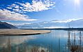
The Indus River near Leh, India.
-
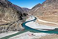
The meeting point of the Indus and Zanskar rivers. The Indus is on the left.
-
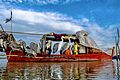
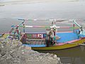
A houseboat of a Mohana family near Kot Addu. This community lives on the Indus River.
-
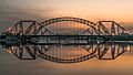
Lansdowne Bridge and Ayub Bridge connecting the cities of Rohri and Sukkur in Sindh, Pakistan.
-
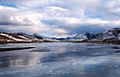
The Indus River frozen near Nyoma.
-
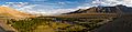
The Indus River at Skardu.
-
The Indus River near Dera Ismail Khan.
-
Areas affected by the Indus River flooding in 2010.
-
Map of the Indus River basin.


.jpg)


See also
 In Spanish: Río Indo para niños
