
Skardu facts for kids
Quick facts for kids
Skardu
|
|
|---|---|
|
City administered by Pakistan
|
|
     Top left to right: Shangrila Resort, Deosai National Park, Trango Towers, Satpara Lake, and Manthokha Waterfall
|
|

A map showing Pakistan-administered Gilgit-Baltistan shaded in sage green in the disputed Kashmir region
|
|
| Administering country | Pakistan |
| Adm. Unit | Gilgit–Baltistan |
| District | Skardu |
| Government | |
| • Type | Divisional Administration |
| Area | |
| • Total | 77 km2 (30 sq mi) |
| Elevation | 2,228 m (7,310 ft) |
| Population
(1998)
|
|
| • Total | 26,023 |
| Time zone | UTC+5:00 (PKT) |
Skardu is a city in Gilgit-Baltistan, a region managed by Pakistan in the disputed Kashmir area. It is the capital of Skardu District and the Baltistan Division. Skardu is located about 2,500 meters (8,200 feet) above sea level in the Skardu Valley. This valley is where the Indus and Shigar rivers meet.
Skardu is a key starting point for exploring the huge Karakoram mountain range nearby. This range includes some of the world's tallest peaks. The Indus River flows through the area, separating the Karakoram mountains from the Ladakh Range.
What's in a Name?
The name "Skardu" likely comes from the Balti language. It means "a lowland between two high places." These two "high places" are thought to be Shigar city and the high-altitude Satpara Lake.
People first wrote about Skardu in the early 1500s. A writer named Mirza Haidar described "Askardu" in a 16th-century book. Later, a French traveler, François Bernier, mentioned the city as "Eskerdou." After that, Skardu started appearing on European maps.
Where is Skardu Located?
The Skardu Valley is about 10 kilometers (6 miles) wide and 40 kilometers (25 miles) long. It sits where the Indus and Shigar Rivers join.
Scientists believe that glaciers from the Indus and Shigar valleys helped shape the Skardu valley. This happened between 3.2 million years ago and about 11,700 years ago.
A Look Back in Time
Early Days

,_Skardu,_Mix_view.JPG)

Long ago, the Skardu region was part of the Buddhist Tibetan Empire. This was around the mid-600s CE. Buddhist writings have been found across Baltistan from this time. Skardu also had connections with tribes near Kashgar in what is now China.
Around the 9th or 10th century CE, Tibet's control over Baltistan ended. Then, a local family called the Maqpon Dynasty took over. Local stories say this dynasty started when a traveler from Kashmir married a local princess.
The Maqpon Kingdom
|
Maqpon kingdom
|
|||||||||||
|---|---|---|---|---|---|---|---|---|---|---|---|
| 1190–1840 | |||||||||||

Map of Kashmir region. Maqpon Kingdom existed in north in Gilgit Baltistan
|
|||||||||||
| Capital | Skardu | ||||||||||
| Religion | Islam | ||||||||||
| Government | Monarchy | ||||||||||
| History | |||||||||||
|
• Established
|
1190 | ||||||||||
|
• Disestablished
|
1840 | ||||||||||
|
|||||||||||
| Today part of | Pakistan India |
||||||||||
The Maqpon kingdom was a powerful state in Baltistan. The Maqpon family ruled the region from Skardu for about 700 years. These kings expanded their kingdom's borders to include areas like Gilgit Agency, Chitral, and Ladakh.
Around the year 1500, Maqpon Bokha became king. He made Skardu his capital and built Skardu Fort. King Makpon Bokha brought skilled workers from Kashmir and Chilas to help the area grow.
Islam also spread to Baltistan in the 14th century. By the end of the 1600s, Islam was the main religion.
.jpg)
One famous Maqpon king was Ali Sher Khan Anchan, who ruled from 1580 to 1624. He made the kingdom even bigger, from Gilgit to Ladakh. He even conquered Leh, the capital of Ladakh, around 1594.
End of Maqpon Rule

In 1839, a commander named Zorawar Singh Kahluria from the Dogra dynasty defeated the Balti forces. He took over Skardu Fort. The Dogra forces killed many of the fort's defenders.
By 1845, the Dogra rulers of Kashmir fully controlled the region. The last Maqpon King was taken prisoner.
Maqpon Rulers List
Here are the rulers of the Maqpon dynasty:
- 1190–1220 Ibrahim
- 1220–1250 Astak Sange
- 1250–1280 Zak Sange
- 1280–1310 Bardak Sange
- 1310–1340 Sek Sange
- 1340–1370 Tam Gori Tham
- 1370–1400 Sa Gori Tham
- 1400–1437 Khohkor Sange
- 1437–1464 Ghota Cho Sange
- 1464–1490 Bahram Cho
- 1490–1515 Bo Kha
- 1515–1540 Sher Shah
- 1540–1565 Ali Khan
- 1565–1590 Ghazi Mir
- 1580–1624 Ali Sher Khan Anchan
- 1624–1636 Abdal Khan
- 1636–1655 Adam Khan
- 1655–1670 Murad Khan
- 1670–1678 Sher Khan
- 1678–1680 Muhammad Rafi Khan
- 1680–1710 Shir Khan
- 1710–1745 Mohammad Rafi
- 1745–1780 Sultan Murad
- 1780–1785 Azam Khan
- 1785–1787 Mohammad Zafar Khan
- 1787–1811 Ali Shir Khan
- 1811–1840 Ahmed Shah
Mughal Influence
In the early 1500s, Sultan Said Khan from the Yarkent Khanate (in what is now China) attacked Skardu. This made the Mughal Empire pay attention. In 1586, the Mughal Emperor Akbar conquered Baltistan. The local Maqpon rulers then promised loyalty to the Mughals. From then on, the kings of Skardu were known as rulers of "Little Tibet" in Mughal history books.
Dogra Administration
After taking over, the Dogra rulers made Skardu and Kargil one district. Skardu became the winter capital, and Leh was the summer capital until 1947. During this time, many Sikhs from Punjab were encouraged to move to Skardu to start businesses.
The 1947–48 Kashmir Conflict
After British India was divided in 1947, a conflict broke out in Kashmir. The Gilgit Scouts, a local force, took control of the Gilgit Agency and joined Pakistan. They then attacked other areas, including Skardu.
The Skardu fort was defended by Indian forces for over six months. But on August 14, 1948, they surrendered.
How Skardu is Governed
Skardu city is a tehsil (a type of administrative division) within Skardu District. The Skardu District is part of the larger Baltistan Division.
A government officer called an Assistant Commissioner manages Skardu city. The whole Skardu District is managed by a Deputy Commissioner.
Skardu's Geography
Mountains and Valleys


Skardu Airport is about 2,230 meters (7,316 feet) above sea level. However, the mountains around Skardu are much taller, reaching 4,500 to 5,800 meters (14,760 to 19,000 feet).
Upstream from Skardu are some of the world's largest glaciers. These include the Baltoro Glacier, Biafo Glacier, and Chogo Lungma Glacier. Some of the tallest mountains in the world are near these glaciers, such as:
- K2: The world's second tallest mountain, at 8,611 meters (28,251 feet).
- Gasherbrum: 8,068 meters (26,470 feet).
- Masherbrum: 7,821 meters (25,659 feet).
The Deosai National Park, the world's second highest alpine plain, is also located upstream from Skardu. Downstream, you can find Nanga Parbat mountain, which is 8,126 meters (26,660 feet) tall.
Rocks and Landforms

Skardu is in an area where different land sections have joined over millions of years. The rocks in the Skardu region are called Katzara schist. They are estimated to be between 37 and 105 million years old.
The Shigar Valley, near Skardu, has many interesting rock formations. It also has the Main Karokoram Thrust, a major geological fault line.
Weather and Climate


Skardu has a cold semi-arid climate. This means it's dry but also has cold winters. In summer, the surrounding mountains keep Skardu from getting too hot. They also block the summer monsoon rains, so summer rainfall is low.
However, these mountains cause very cold winters. From April to October, which is the tourist season, temperatures are usually between 8°C (46°F) and 27°C (81°F). In December and January, temperatures can drop below -10°C (14°F). The lowest temperature ever recorded was -24.1°C (-11.4°F) in January 1995.
| Climate data for Skardu | |||||||||||||
|---|---|---|---|---|---|---|---|---|---|---|---|---|---|
| Month | Jan | Feb | Mar | Apr | May | Jun | Jul | Aug | Sep | Oct | Nov | Dec | Year |
| Record high °C (°F) | 13.9 (57.0) |
16.7 (62.1) |
24.0 (75.2) |
29.6 (85.3) |
34.4 (93.9) |
40.0 (104.0) |
41.0 (105.8) |
41.0 (105.8) |
38.2 (100.8) |
31.2 (88.2) |
22.9 (73.2) |
16.2 (61.2) |
41.0 (105.8) |
| Mean daily maximum °C (°F) | 3.2 (37.8) |
6.1 (43.0) |
12.4 (54.3) |
18.8 (65.8) |
23.4 (74.1) |
28.7 (83.7) |
31.6 (88.9) |
31.2 (88.2) |
27.2 (81.0) |
20.4 (68.7) |
13.2 (55.8) |
6.5 (43.7) |
14.9 (58.8) |
| Mean daily minimum °C (°F) | −8.0 (17.6) |
−4.4 (24.1) |
1.5 (34.7) |
6.6 (43.9) |
9.7 (49.5) |
13.4 (56.1) |
16.4 (61.5) |
16.0 (60.8) |
11.4 (52.5) |
4.3 (39.7) |
−1.9 (28.6) |
−5.6 (21.9) |
4.1 (39.4) |
| Record low °C (°F) | −24.1 (−11.4) |
−20.0 (−4.0) |
−13.5 (7.7) |
−1.1 (30.0) |
0.4 (32.7) |
4.0 (39.2) |
7.5 (45.5) |
7.0 (44.6) |
2.6 (36.7) |
−4.2 (24.4) |
−9.5 (14.9) |
−17.2 (1.0) |
−24.1 (−11.4) |
| Average rainfall mm (inches) | 27.5 (1.08) |
25.9 (1.02) |
36.9 (1.45) |
31.3 (1.23) |
25.3 (1.00) |
9.0 (0.35) |
9.8 (0.39) |
12.2 (0.48) |
9.3 (0.37) |
7.3 (0.29) |
5.6 (0.22) |
16.3 (0.64) |
172.7 (6.80) |
| Average relative humidity (%) (at 17:00 PST) | 64.3 | 52.0 | 34.9 | 25.6 | 24.6 | 22.3 | 27.3 | 30.7 | 29.9 | 31.2 | 36.6 | 56.2 | 29.6 |
| Source: Pakistan Meteorological Department | |||||||||||||
Exploring Skardu: Tourism

Skardu is a major center for tourism, trekking, and mountain expeditions in Gilgit–Baltistan. The region's mountains, including four of the world's 14 highest peaks, attract visitors from all over. The best time to visit is from April to October. During winter, heavy snow can cut off the area. Skardu now has an international airport, making it easier for tourists to visit.
Amazing Mountains
_skardu._photo_by_me.jpg)
From Skardu, you can reach places like Askole and Hushe. These are starting points for trips to huge, snow-covered peaks over 8,000 meters (26,000 feet) tall. These include K2, the Gasherbrums, Broad Peak, and the Trango Towers. You can also visit massive glaciers like Baltoro, Biafo, and Trango.
Because of this, Skardu is a main base for mountaineers. It has many shops and hotels for visitors.
Deosai National Park
The Deosai National Park is a famous place to visit. The Deosai Plains are the second highest in the world, at 4,114 meters (13,497 feet) above sea level. In the local Balti language, "Deosai" means 'summer place'.
The plains cover about 3,000 square kilometers (1,158 square miles). They are home to amazing animals like snow leopards, ibex, Tibetan blue bears, and wild horses.
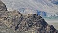
Skardu Fort

Skardu Fort, also called Kharpocho Fort, sits on a hill about 15 meters (49 feet) above Skardu town. The fort dates back to the 700s CE. It also has an old mosque from when Islam arrived in the 1500s.
From the fort, you get amazing views of Skardu town, the valley, and the Indus River. The Maqpon dynasty rulers of Baltistan built this fort. It used to have seven stories. Local people sometimes say that ghosts helped build Kharpocho because it was so grand.
Kharphocho Fort was designed like the Leh Palace and the Potala Palace in Lhasa, Tibet. "Kharpochhe" means "the great fort" in Tibetan.
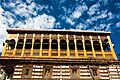
Shigar Fort

On the way to K2, you can find Shigar Fort. It's also known as Fong-Khar, meaning "Palace on the Rock" in the local language. The fort complex includes the 400-year-old palace and two newer buildings.
The old palace of the Raja of Shigar is now a guesthouse with 20 rooms. Its grand hall is a museum showing Balti culture, with beautiful wood carvings and other old items.
Kachura Lakes
There are two Kachura lakes in Kachura Valley. One is the less known Upper Kachura Lake, and the other is the famous Shangrila Lake, also called Lower Kachura Lake.
Shangrila Lake is home to the Shangrila Resort hotel. This resort is built in a Chinese style and is very popular with tourists. It even has a unique restaurant inside an old airplane that crashed there in 1953!
Kachura Lake is known for its deep blue water. The lakes are about 2,500 meters (8,200 feet) high.
Satpara Lake
Satpara Lake is the main lake in Skardu Valley. It's about 6 kilometers (4 miles) from Skardu. This lake is a great place for trout fishing and boating. It also provides drinking water for Skardu city.
In 2002, the government decided to build a dam on Satpara Lake. The dam was mostly finished in 2011. It now produces electricity and provides water for farming and drinking.
Getting Around Skardu
Roads


The main road to Skardu is the Karakorum Highway, which connects to the Skardu Road (S1). Roads once linked Skardu to Srinagar and Leh, but these are not open for travel across the border.
Winter weather can make travel difficult. Roads to Skardu can be blocked by snow for long periods. Sometimes, flying is the only way to get in or out.
Air Travel
On December 2, 2021, Skardu International Airport was officially opened as an international airport. It was upgraded to become a major hub for tourism in Gilgit-Baltistan.
A foreign airline, Flydubai, has even asked to start international flights to Skardu. This would make it the first airline to offer international routes from Skardu.
Important Projects
Satpara Dam
The Satpara Dam project on Satpara Lake started in 2003 and was finished in 2011. It is about 6 kilometers (4 miles) south of Skardu city. The dam gets its water from melting ice from the Deosai plains in summer.
The Satpara Dam now provides drinking water to all of Skardu city. It also supplies water for farming to many areas around Skardu. This project produces 17.36 megawatts of electricity and helps irrigate 15,000 acres (61 square kilometers) of land.
Famous People from Skardu
- Amen Aamir: The first woman from Gilgit-Baltistan to become a pilot.
- Ali Sadpara: (1976–2021) A famous Pakistani high-altitude mountaineer. He was born in Sadpara village, near Skardu.
Images for kids
-
Skardu Fort was the seat of power of the Maqpon Dynasty
-
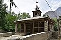
The Chaqchan Mosque was built in 1370 in Baltistan
-
Amburiq Mosque was built in the 14th century


See also
 In Spanish: Skardu para niños
