
Gilgit-Baltistan facts for kids
Quick facts for kids
Gilgit-Baltistan
گلگت - بلتستان
|
|||
|---|---|---|---|
| Gilgit-Baltistān | |||

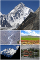
Biafo Glacier, Gilgit, Pakistan.
|
|||
|
|||
_(disputed_hatched)_(claims_hatched).svg)
Location of Gilgit-Baltistan, disputed (red) and (white), with Siachen Glacier (1949-1984)
|
|||
 |
|||
| Country | Pakistan | ||
| Established | 1 July 1970 | ||
| Capital | Gilgit | ||
| Largest city | Gilgit | ||
| Government | |||
| • Type | Self-governing territory of Pakistan | ||
| • Body | Legislative Assembly | ||
| Area | |||
| • Total | 72,971 / 64,817 km2 (0.43466991684284 sq mi) | ||
| Population
(2008; est.)
|
|||
| • Total | 1,800,000 | ||
| • Density | 0/km2 (0/sq mi) | ||
| Time zone | UTC+5 (PKT) | ||
| ISO 3166 code | PK-NA | ||
| Main Language(s) |
|
||
| Assembly seats | 33 | ||
| Districts | 10 | ||
| Website | gilgitbaltistan.gov.pk | ||

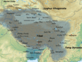
Gilgit-Baltistan (Urdu: گلگت بلتستان), once called the Northern Areas, is a special territory in the northern part of Pakistan. It is larger than Sierra Leone but smaller than Panama. This area used to be part of the Princely state of Kashmir and Jammu in the 1800s.
Gilgit-Baltistan shares borders with Azad Jammu and Kashmir to the south. It also borders Indian-administered Kashmir to the southeast and Pakistan's Khyber Pakhtunkhwa province to the west. Internationally, it borders Afghanistan to the north and People's Republic of China to the northeast. Tajikistan is only 14 kilometers away, separated by the Wakhan Corridor.
In 1970, Gilgit-Baltistan became a single administrative unit. It was formed by combining the Gilgit Agency, the Baltistan District of the Ladakh Wazarat, and the states of Hunza and Nagar. This region is part of the ongoing Kashmir dispute. Pakistan considers the entire area of Jammu and Kashmir a "disputed territory." They believe its future should be decided by a vote among the people. Gilgit-Baltistan is governed by a Governor and a Chief Minister, who is chosen by a local assembly. The area covers about 64,817 square kilometers.
Contents
History of Gilgit-Baltistan
Historically, Gilgit-Baltistan was part of the princely state of Jammu and Kashmir. After India was divided in 1947, this territory became part of a dispute. Pakistan has controlled the area since October 1947.
Self-Rule and Development
On August 29, 2009, Pakistan's government passed an order called the Gilgit-Baltistan Empowerment and Self-Governance Order 2009. This order gave the people of Gilgit-Baltistan more self-rule. It created an elected assembly for the region.
However, some groups in Gilgit-Baltistan wanted even more independence. They asked for a fully independent assembly. They also wanted to elect their own president and prime minister.
In September 2009, Pakistan and People's Republic of China signed an agreement. They planned to build a large energy project in Gilgit-Baltistan. This included a 7,000-megawatt dam in the Astore District. India protested this project, but Pakistan said India had no right to object.
Later that month, Pakistan's Prime Minister announced a big development plan for Gilgit-Baltistan. This plan aimed to improve education, health, farming, and tourism. He said the people were finally getting their own identity. This gave Gilgit-Baltistan a status similar to a province, but it is not officially a province of Pakistan. This is because of the Kashmir dispute.
In 1982, the Pakistani President said that the people of the Northern Areas were Pakistanis. He stated they were not connected to the State of Jammu and Kashmir. In 1993, Pakistan's highest court stopped an attempt to join Gilgit-Baltistan with Azad Kashmir. This was after protests from the people of Gilgit-Baltistan.
People and Languages
The main languages spoken in Gilgit-Baltistan are Balti, Shina, Burushaski, Wakhi, and Khowar.
How Gilgit-Baltistan is Governed
The Government of Gilgit-Baltistan is the main governing body for the territory. It has 10 districts. The government has three parts:
- The executive, led by the Governor of Gilgit-Baltistan.
- The judiciary, which handles laws.
- The legislative branch, which makes laws.
The Governor is the head of state, similar to other regions in Pakistan. The President of Pakistan chooses the Governor. The Governor's role is mostly ceremonial, meaning they don't have much power. The Chief Minister is the head of government. They hold most of the real power.
The Gilgit-Baltistan Legislative Assembly is a single-chamber body with 33 seats. It was created in 2009 to give the region self-rule. Before this, the area was directly controlled by Islamabad.
Districts of Gilgit-Baltistan
Gilgit-Baltistan is divided into 10 districts:
- Astore District (part of Diamir Division)
- Diamir District (part of Diamir Division)
- Ghanche District (part of Baltistan Division)
- Ghizar District (part of Gilgit Division)
- Gilgit District (part of Gilgit Division)
- Hunza District (part of Gilgit Division)
- Nagar District (part of Gilgit Division)
- Skardu District (part of Baltistan Division)
- Shigar District (part of Baltistan Division)
- Kharmang District (part of Baltistan Division)
Geography and Climate


Gilgit-Baltistan is bordered by the Wakhan corridor of Afghanistan to the northwest. To the northeast is China's Xinjiang region. The disputed territory of Jammu and Kashmir is to the south and southeast. Pakistan's Azad Jammu and Kashmir is to the south. Finally, Pakistan's Khyber Pakhtunkhwa province is to the west.
This region is home to five of the world's "eight-thousanders" (mountains over 8,000 meters tall). It also has more than fifty peaks above 7,000 meters. The cities of Gilgit and Skardu are popular starting points for mountain expeditions. The main mountain ranges here are the Karakoram Mountains and the western Himalayas. The Pamir mountains are to the north, and the Hindu Kush is to the west. Among the highest mountains are K2 (Mount Godwin-Austen) and Nanga Parbat. Nanga Parbat is known as one of the most challenging mountains to climb.
The Deosai Plains are a high plateau. They are the second-highest plateau in the world, at 4,115 meters (14,500 feet). Only the Chinese region of Tibet is higher. The plateau is east of Astore, south of Skardu, and west of Ladakh. In 1993, this area became a national park. The Deosai Plains cover almost 5,000 square kilometers. For more than half the year, from September to May, Deosai is covered in snow. During these months, it is cut off from the rest of Astore and Baltistan.
Images for kids
-
Map of Tibetan Empire showing Gilgit-Baltistan as part of its kingdom around 780–790 CE.
-
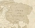
The princely state of Jammu and Kashmir in 1946. It shows the Gilgit Agency and Baltistan.
-
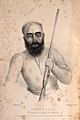
The last Maqpon Raja Ahmed Shah.
-
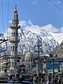
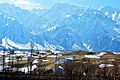
Snow-covered mountains seen from Raja Bazar Road in Gilgit.
-
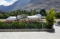
A collection of images from Gilgit-Baltistan.
-
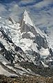
View of Laila Peak near Hushe Valley.
-
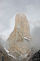
The Trango Towers are famous for challenging rock climbing.
-
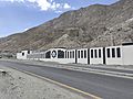
Sui Northern Gas Pipelines Limited LPG Air Mix Plant in Gilgit.
-
Cold Desert, Skardu is the world's highest desert.
-
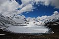
Rush Lake in Nagar, Pakistan.
-
The Karakoram Highway.
-
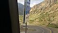
National Highway N-15 has sharp turns, making it a challenge for drivers.
-
ATR 42–500 airplane at Gilgit Airport.
-
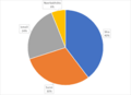
A chart showing the different religious groups in Gilgit-Baltistan.
-
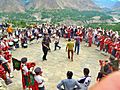
Guests dancing with traditional music at Baltit Fort in 2014.
-
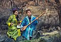
Wakhi musicians in Gulmit.
-
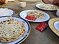
Chapchor is a popular dish in Nagar Valley and Hunza Valley.
-
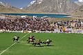
Polo game with Shandur Lake in the background, at Shandur.
-
Satpara Lake in Skardu.
-
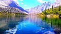
Upper Kachura Lake.
-
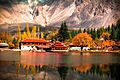
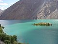
Shangrila Lake in Skardu.
-
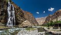
Manthokha Waterfall.


.jpg)


See also
 In Spanish: Gilgit-Baltistán para niños
