
Kashmir and Jammu facts for kids
Quick facts for kids Kashmir and Jammu |
|||||||||
|---|---|---|---|---|---|---|---|---|---|
| Princely State | |||||||||
| 1846–1971 | |||||||||
 Coat of arms
|
|||||||||
| Historical era | New Imperialism | ||||||||
|
• Established
|
1846 | ||||||||
|
• Partition of Pakistan
|
1971 | ||||||||
|
|||||||||
Kashmir and Jammu was a special kind of kingdom called a princely state. It was located in the Himalayas mountains, right next to the lands controlled by British India in the north. A Hindu ruler, known as a Maharaja, was in charge of this state.
This state was formed in 1846. This happened after the Sikhs, who had ruled the area, were defeated in a war. The East India Company, a powerful British trading company, took over the Kashmir Valley. They wanted to get back some of the money they spent fighting the Anglo-Sikh war.
So, the Kashmir valley, where most people were Muslim, was sold to Gulab Singh, the Dogra ruler of Jammu. This agreement was made official by the Treaty of Amritsar. The treaty also set the borders of the new state. It covered an area of 80,900 square kilometers. This land was "eastward of the Indus and westward of the Ravi River".
When the British left India in 1947, the princely state of Kashmir and Jammu faced a big decision. It became divided between the new countries of Pakistan and India after a war broke out. Both countries still believe the entire former state belongs to them. This has led to several conflicts over the years. The Kashmir conflict is still a difficult and long-lasting problem that the United Nations Security Council has tried to help solve.
Contents
How Kashmir and Jammu Was Created
Before it became a princely state, Kashmir was ruled by the Durrani Empire. Then, the Sikhs, led by Ranjit Singh, took control. During Sikh rule, Jammu was a smaller kingdom that paid tribute to the Sikh Empire in the Punjab region.
When Jammu's ruler, Raja Kishore Singh, died in 1822, his son, Gulab Singh, was recognized as his heir by the Sikhs. Gulab Singh then started to make his kingdom much bigger.
Gulab Singh's Expansion
As the ruler of Jammu, Gulab Singh first took over Bhadarwah and then Kishtwar. Taking Kishtwar was important because it gave him control of two main roads leading into Ladakh. This helped him conquer Ladakh, even though it was very difficult due to the high mountains and glaciers. Gulab Singh's officer, Zorawar Singh, led the Dogra army to conquer all of Ladakh.
A few years later, in 1840, General Zorawar Singh invaded Baltistan. He captured the Raja of Skardu, who had sided with the Ladakhis, and took over his country. The next year, in 1841, Zorawar Singh tried to invade Tibet. However, the harsh winter weather and attacks from the Tibetans led to his death and the loss of almost his entire army.
In the winter of 1845, a war began between the British and the Sikhs. Gulab Singh stayed neutral at first. But during the battle of Sobraon in 1846, he became a trusted advisor to Sir Henry Lawrence. This helped him gain a lot of land for himself. This land included all the hilly or mountainous areas to the east of the Indus and west of the Ravi River.
Taking control of Kashmir itself was not easy for the Maharaja. His army had to fight Imam-ud-din, the Sikh governor. Imam-ud-din was helped by the Bambas from the Jhelum valley. They managed to defeat Gulab Singh's troops near Srinagar, and Gulab Singh's general, Wazir Lakhpat, was killed. However, Sir Henry Lawrence later convinced Imam-ud-din to stop fighting. Because of this, Kashmir became part of the new ruler's state without more battles.
Growth of the State
Not long after, the Hunza Raja attacked Gilgit territory. Nathu Shah, acting for Gulab Singh, led an army to attack the Hunza valley. But his force was destroyed, and Gilgit fort fell to the Hunza Raja. Other areas like Punial, Yasin, and Darel were also lost.
The Maharaja then sent two more armies. One came from Astor and another from Baltistan. After some fighting, Gilgit fort was taken back. However, in 1852, the Dogra troops were defeated by Gaur Rahman of Yasin. For eight years after that, the Indus River marked the edge of the Maharaja's lands.
Gulab Singh died in 1857. His son, Ranbir Singh, became the new ruler. Ranbir Singh supported the British during the Indian Rebellion. After the British put down the rebellion, Ranbir decided to take back Gilgit. In 1860, an army led by Devi Singh crossed the Indus River. They moved towards Gaur Rahman's strong fort at Gilgit. Gaur Rahman had died just before the Dogra army arrived. The fort was captured and remained under the Maharajas' control until 1947.
Even though Ranbir Singh was fair to different religions, his control over the country was not very strong. Between 1877 and 1879, a terrible famine hit Kashmir.
Where Kashmir and Jammu Was Located
Jammu was the southernmost part of the state. It was next to the Punjab districts of Jhelum, Gujrat, Sialkot, and Gurdaspur.
Travel and Roads
There used to be a main road from Kohala to Leh. People could travel from Rawalpindi through Kohala and over the Kohala Bridge to enter Kashmir. The road from Kohala to Srinagar was a cart-road, 132 miles long. From Kohala to Baramulla, the road ran close to the Jhelum River.
At Muzaffarabad, the Kishenganga River joins the Jhelum. At this point, roads from Abbottabad and Garhi Habibullah also met the Kashmir route. This road was very busy and needed to be repaired many times by the authorities.
End of the Princely State
In 1947, the Indian Independence Act was passed. This law meant that British India would become two independent countries: Pakistan and India. It also meant that each of the princely states could choose to join India, join Pakistan, or remain independent. In the end, all princely states became part of either Pakistan or India.
However, the ruler of Kashmir wanted to stay independent. He did not want to join Pakistan or India. This led to a war between the two new countries. As a result, Kashmir became divided between them. Both India and Pakistan believe that the entire former princely state belongs to them. This disagreement has caused several wars. The Kashmir conflict between these two countries, which both have nuclear weapons, is still one of the most difficult and long-lasting disputes that the United Nations Security Council has been trying to resolve.
The Maharaja of Kashmir signed a document called an "Instrument of Accession" with India. By doing this, he decided to join the Republic of India. This was similar to what 584 other kingdoms had done before August 15, 1947. Later, Pakistani forces entered Kashmir and still control almost 40% of this state. Pakistan also gave a large part of Kashmir to China.
Other Pages to Explore
Images for kids
-
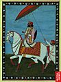
Gulab Singh, the founder and the first Maharaja of the princely state of Jammu & Kashmir.
-

Flag of J&K (1846–1936)
-
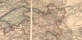
Map of the Jammu and Kashmir state, Edward Stanford Ltd., 1885
-
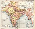
1909 map showing Kashmir


See also
 In Spanish: Jammu y Cachemira para niños
