
Muzaffarabad facts for kids
Quick facts for kids
Muzaffarabad
مظفر آباد
|
|
|---|---|
|
City administered by Pakistan
|
|

|
|

A map showing Pakistan-administered Azad Kashmir shaded in sage in the disputed Kashmir region
|
|
| Administering country | Pakistan |
| Territory | Azad Kashmir |
| District | Muzaffarabad |
| Founded by | Sultan Muzaffar Khan |
| Elevation | 737 m (2,418 ft) |
| Population
(2017)
|
|
| • City | 149,913 |
| • Rank | 60th, Pakistan |
| Languages | |
| • Official | Urdu |
| • Spoken | |
| Time zone | UTC+05:00 (PST) |
| Calling code | 05822 |
| Website | Muzaffarabad Government Portal (defunct) |
Muzaffarabad is a major city in Pakistani-administered Azad Kashmir. It is the capital and largest city of Azad Kashmir, which is a territory managed by Pakistan.
The city sits in the Muzaffarabad District. It is located where the Jhelum and Neelum rivers meet. To the west, the district borders the Pakistani province of Khyber Pakhtunkhwa. To the east, it borders the Kupwara and Baramulla districts of Indian-administered Jammu and Kashmir. The Neelum District is to its north.
Contents
History of Muzaffarabad
Muzaffarabad was founded in 1646 by Sultan Muzaffar Khan. He was the chief of the Bomba tribe and ruled Kashmir. In the same year, Khan also built the Red Fort. This fort was made to defend against attacks from the Mughal Empire.
Conflict in 1947
A battle took place in Muzaffarabad on October 22, 1947. It was between Pakistani-backed tribesmen and the Jammu and Kashmir State Forces. The tribesmen quickly defeated the State Forces. This led to the tribesmen taking control of Muzaffarabad.
The 2005 Earthquake
In 2005, a powerful earthquake hit near Muzaffarabad. It had a magnitude of 7.6. This earthquake destroyed about half of the city's buildings. Many government buildings were also ruined. It is thought that up to 80,000 people died in the Pakistani-controlled areas. By October 8, 2005, the official death toll from the Pakistani government was 87,350. Some estimates even put the number of deaths over 100,000.
City Divisions

The Muzaffarabad district is split into two main parts called tehsils. These are further divided into 25 smaller areas called union councils.
- Muzaffarabad
- Pattika (Naseerabad)
Climate and Weather
| Climate data for Muzaffarabad (1961–2009) | |||||||||||||
|---|---|---|---|---|---|---|---|---|---|---|---|---|---|
| Month | Jan | Feb | Mar | Apr | May | Jun | Jul | Aug | Sep | Oct | Nov | Dec | Year |
| Record high °C (°F) | 27.0 (80.6) |
29.4 (84.9) |
37.0 (98.6) |
40.5 (104.9) |
46.5 (115.7) |
46.2 (115.2) |
45.0 (113.0) |
40.2 (104.4) |
39.0 (102.2) |
38.3 (100.9) |
33.0 (91.4) |
27.0 (80.6) |
46.5 (115.7) |
| Mean daily maximum °C (°F) | 16.0 (60.8) |
18.0 (64.4) |
22.6 (72.7) |
28.3 (82.9) |
33.5 (92.3) |
37.4 (99.3) |
34.9 (94.8) |
34.0 (93.2) |
33.4 (92.1) |
30.1 (86.2) |
24.2 (75.6) |
18.1 (64.6) |
22.3 (72.1) |
| Mean daily minimum °C (°F) | 3.1 (37.6) |
5.4 (41.7) |
9.7 (49.5) |
14.2 (57.6) |
18.4 (65.1) |
21.9 (71.4) |
22.8 (73.0) |
22.6 (72.7) |
19.4 (66.9) |
13.7 (56.7) |
7.8 (46.0) |
4.1 (39.4) |
11.1 (52.0) |
| Record low °C (°F) | −3.0 (26.6) |
−1.1 (30.0) |
1.0 (33.8) |
6.5 (43.7) |
7.0 (44.6) |
12.0 (53.6) |
15.5 (59.9) |
16.0 (60.8) |
12.4 (54.3) |
6.5 (43.7) |
1.0 (33.8) |
−1.4 (29.5) |
−3 (27) |
| Average rainfall mm (inches) | 101.3 (3.99) |
137.4 (5.41) |
157.3 (6.19) |
109.0 (4.29) |
78.5 (3.09) |
113.6 (4.47) |
328.7 (12.94) |
229.9 (9.05) |
112.6 (4.43) |
45.9 (1.81) |
37.2 (1.46) |
69.0 (2.72) |
1,242.8 (48.93) |
| Average relative humidity (%) (at 12:00 PST) | 50.3 | 46.3 | 40.9 | 38.0 | 33.2 | 34.0 | 52.2 | 57.6 | 48.1 | 42.4 | 48.4 | 54.0 | 37.2 |
| Source: Pakistan Meteorological Department | |||||||||||||
Muzaffarabad has a varied climate. Summers can be very hot, with temperatures sometimes reaching over 40°C (104°F). Winters are cooler, with average low temperatures around 3-5°C (37-41°F). The city receives a good amount of rain, especially during the monsoon season in July and August.
Getting Around the City
Muzaffarabad's public transport mainly uses buses, rickshaws, and small pickup trucks. These help people travel within the city. After the big 2005 Kashmir earthquake damaged many roads, the city got help from other countries. They rebuilt roads, bridges, and other important structures. However, public transport still needs more development. Muzaffarabad does not have a railway system or a working airport. The closest train station is in Rawalpindi District in Pakistani Punjab.
Famous People
- Anam Najam, a medical doctor and psychiatrist.
- Rashid Naseer, a Pakistani cricketer.
- Farooq Haider Khan, a politician.
Gallery
-
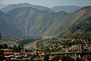
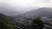
Heightened view of the city on both riverbanks after the 2005 Kashmir earthquake, c. 2014
-
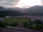
Photo of Muzaffarabad Cricket Stadium
-
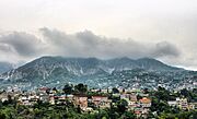
Photo of the city's skyline, c. 2017
-
Azad Jammu Kashmir Medical College
-
Muzaffarabad City, Azad Kashmir, Pakistan


See also
 In Spanish: Muzaffarabad para niños
