
Rawalpindi District facts for kids
Quick facts for kids
Rawalpindi District
|
|
|---|---|

Map of Punjab with Rawalpindi District highlighted
Rawalpindi is located in the north of Punjab. |
|
| Country | Pakistan |
| Province | Punjab |
| Capital | Rawalpindi |
| Area | |
| • Total | 5,286 km2 (2,041 sq mi) |
| Population
(2010)
|
|
| • Total | 4,500,000 |
| Time zone | UTC+5 (PST) |
| Number of Tehsils | 7 |
| Website | http://www.rawalpindi.gov.pk |
Rawalpindi District (Urdu: ضلع راولپنڈی) is an important area in the Punjab province of Pakistan. It's like a large county, and its main city is Rawalpindi, which is also its capital. This district is known for its history and beautiful landscapes.
Contents
Rawalpindi District: A Closer Look
Rawalpindi District is located in the northern part of Punjab, Pakistan. It covers a total area of about 5,286 square kilometers. In 2010, around 4.5 million people lived here. The district is divided into smaller parts called tehsils, which help manage the area.
Parts of Rawalpindi District
The district is split into seven smaller administrative areas called tehsils. Each tehsil has its own local government and helps manage the services for the people living there. These tehsils are:
- Gujar Khan Tehsil
- Kahuta Tehsil
- Kallar Syedan Tehsil
- Kotli Sattian Tehsil
- Murree Tehsil
- Rawalpindi Tehsil
- Taxila Tehsil
People and Languages
Rawalpindi District is home to many different people. In the past, various groups like Sikhs, Hindus, and Muslims lived here. Over time, the population grew, and the district became a mix of different cultures. Today, the main languages spoken are Potahari, Punjabi, Pashto, and Urdu. This mix of languages shows the rich cultural background of the area.
Images for kids
-
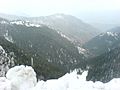
Road from Mureee to Rawalpindi
-
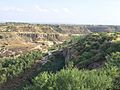
Potohar Plateau in Rawalpindi-District
-
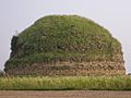
Mankiala Stupa 27 kilometres (17 mi) from Rawalpindi city


See also
 In Spanish: Distrito de Rawalpindi para niños
