Kupwara district facts for kids
Quick facts for kids
Kupwara district
Kopwor
|
|
|---|---|
|
District of Jammu and Kashmir administered by India
|
|

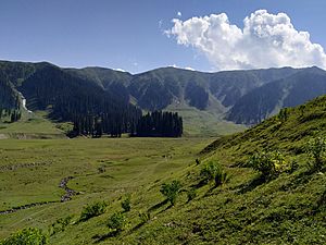
Bangus Valley in Kupwara
|
|

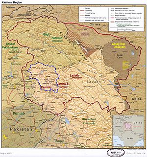
Kupwara district is in Indian-administered Jammu and Kashmir in the disputed Kashmir region It is in the Kashmir division (bordered in neon blue).
|
|
| Administering country | India |
| Union Territory | Jammu and Kashmir |
| Division | Kashmir Division |
| Headquarters | Kupwara |
| Area | |
| • Total | 2,379 km2 (919 sq mi) |
| • Urban | 47.3 km2 (18.3 sq mi) |
| • Rural | 2,331.7 km2 (900.3 sq mi) |
| Population
(2011)
|
|
| • Total | 870,354 |
| • Density | 365.85/km2 (947.54/sq mi) |
| • Urban | 104,729 |
| • Rural | 765,625 |
| Demographics | |
| • Literacy | 64.51% |
| • Sex ratio | 835 ♀/ 1000 ♂ |
| Languages | |
| • Official | Kashmiri, Urdu, Hindi, Dogri, English |
| Time zone | UTC+05:30 (IST) |
| Vehicle registration | JK-09 |
| Major highways | |
Kupwara district is a part of Jammu and Kashmir, which is a territory in India. It's located in the beautiful Kashmir Valley. This district is one of ten districts in the Kashmir Valley Division. Two important rivers flow through Kupwara: the Pohru River and the Mawar River. Both of these rivers eventually join the Jhelum River in the nearby Baramulla district.
Contents
History of Kupwara
Kupwara district was created in 1979. Before that, it was part of the Baramulla district. The main town and headquarters of the district is Kupwara.
Geography of Kupwara
Kupwara district covers an area of about 2,379 square kilometers. It shares its borders with several other areas. To the east, it's next to Bandipora district. To the south, it borders Baramulla district. On its northern and western sides, it borders parts of Pakistan-administered Jammu and Kashmir. Most of the land in Kupwara district is rural, meaning it's used for farming.
Neighboring Areas
Kupwara district is surrounded by these areas:
- Bandipora district (in India) – to the east
- Neelum district (in Pakistan-administered Jammu and Kashmir) – to the northeast and northwest
- Muzaffarabad district and Hattian Bala district (in Pakistan-administered Jammu and Kashmir) – to the west
- Baramulla district (in India) – to the south
Economy and Jobs
Most people in Kupwara district work in agriculture and horticulture. This means they grow crops and fruits. One very important crop here is walnuts. Kupwara is known for producing and selling a lot of walnuts. The Department of Horticulture has even set up a special nursery in Kupwara to grow high-quality walnut trees.
People of Kupwara
| Historical population | ||
|---|---|---|
| Year | Pop. | ±% p.a. |
| 1901 | 110,979 | — |
| 1911 | 124,744 | +1.18% |
| 1921 | 137,936 | +1.01% |
| 1931 | 153,758 | +1.09% |
| 1941 | 170,079 | +1.01% |
| 1951 | 187,076 | +0.96% |
| 1961 | 204,073 | +0.87% |
| 1971 | 257,824 | +2.37% |
| 1981 | 328,743 | +2.46% |
| 1991 | 465,948 | +3.55% |
| 2001 | 650,393 | +3.39% |
| 2011 | 870,354 | +2.96% |
| source: | ||
According to the 2011 census, Kupwara district had a population of 870,354 people. This made it the 470th most populated district out of 640 in India. The district has about 368 people living in each square kilometer. Between 2001 and 2011, the population grew by 34.62%.
Kupwara has a sex ratio of 843 females for every 1000 males. The literacy rate (the number of people who can read and write) is 75.60%.
| Religion in Kupwara district (2011) | ||||
|---|---|---|---|---|
| Religion | Percent | |||
| Islam | 94.59% | |||
| Hinduism | 4.27% | |||
| Sikhism | 0.64% | |||
| Other or not stated | 0.50% | |||
| Sex Ratio in Kupwara District in 2011 Census. (no. females per 1,000 males) |
||||
|---|---|---|---|---|
| Religion (and population) | Sex Ratio | |||
| Muslim (pop 823,286) | 912 | |||
| Hindu (pop 37,128) | 30 | |||
| Sikh (pop 5,600) | 162 | |||
| Other (pop 1,818) | 395 | |||
| Not stated (pop 2,522) | 695 | |||
| Total (pop 870,354) | 835 | |||
In 2011, most people in Kupwara district spoke Kashmiri (71.11%). Other languages spoken include Pahari (14.12%), Gojri (9.21%), and Hindi (2.70%). Urdu is also widely spoken as a second language.
Getting Around Kupwara
Air Travel
The closest airport to Kupwara is Sheikh ul-Alam International Airport in Srinagar. It's about 102 kilometers away from Kupwara town. There are plans to build a new airport in Panzgam.
Train Travel
Currently, Kupwara district does not have its own railway connection. However, there are plans to extend the Jammu–Baramulla line to reach Kupwara in the future. The nearest train station right now is Baramulla railway station, which is 45 kilometers from Kupwara.
Road Travel
Kupwara is well-connected by roads and highways. The NH 701 passes through the district. There are also many other roads that connect different parts of the district.
More to Explore
 In Spanish: Distrito de Kupwara para niños
- Jammu and Kashmir
- Kupwara
- Lolab Valley
- Karnah
- Drugmulla
- Tangdhar
- Sogam Lolab
- Sports in Jammu and Kashmir
- Diver Anderbugh
- Bangus Valley
 | William Lucy |
 | Charles Hayes |
 | Cleveland Robinson |

