
Srinagar facts for kids
Quick facts for kids
Srinagar
|
|
|---|---|
|
City
|
|
      From the top, clockwise:
Houseboats on Dal lake, Tulips at Indira Gandhi Memorial Tulip Garden, Hazratbal shrine, Panorama of Srinagar City, Pari Mahal and Shankaracharya Temple |
|

Srinagar lies in the Kashmir division (neon blue) of the Indian-administered Jammu and Kashmir (shaded tan) in the disputed Kashmir region. =
|
|
| Administering country | India |
| Region of administration | Union Territory of Jammu and Kashmir |
| Division | Kashmir |
| District | Srinagar |
| Named for | Lakshmi or Surya |
| Government | |
| • Type | Municipal corporation |
| • Body | Srinagar Municipal Corporation |
| Area | |
| • City | 294 km2 (114 sq mi) |
| • Metro | 766 km2 (296 sq mi) |
| Elevation | 1,585 m (5,200 ft) |
| Population
(2011)
|
|
| • City | 1,180,570 |
| • Rank | 31st |
| • Density | 4,016/km2 (10,400/sq mi) |
| • Metro | 1,273,312 |
| • Metro Rank | 37th |
| Demonym(s) | Srinagari, Sirinagari, Sirinagaruk, Shaharuk, Srinagarite |
| Languages | |
| • Official | Kashmiri, Urdu, Hindi, Dogri, English |
| Time zone | UTC+5:30 (IST) |
| PIN |
190001
|
| Telephone code | 0194 |
| Vehicle registration | JK 01 |
| Sex ratio | 888 ♀/ 1000 ♂ |
| Literacy | 69.15% |
| Distance from Delhi | 876 kilometres (544 mi) NW |
| Distance from Mumbai | 2,275 kilometres (1,414 mi) NE (land) |
| Climate | Cfa |
| Precipitation | 710 millimetres (28 in) |
| Avg. summer temperature | 23.3 °C (73.9 °F) |
| Avg. winter temperature | 3.2 °C (37.8 °F) |
Srinagar is a famous city in Jammu and Kashmir, a region managed by India. It is the biggest city and the summer capital of this area. Srinagar is located in the beautiful Kashmir Valley. It sits along the Jhelum River and near the shores of Dal Lake and Anchar Lake. The city is surrounded by hills like Hari Parbat and Shankaracharya.
Srinagar is well-known for its stunning natural beauty, lovely gardens, and unique houseboats. It is also famous for traditional Kashmiri handicrafts. These include the Kashmir shawl (made from soft pashmina and cashmere wool), papier-mâché items, wood carvings, and beautiful carpets. The city is also a place where you can find delicious dried fruits. Srinagar is the second-largest city in the Himalayas, after Kathmandu in Nepal.
The city was founded a long time ago, in the 6th century. It became an important center for learning under Hindu rulers. From the 14th to 16th centuries, the city grew a lot. It became a spiritual hub and a center for making shawls and other crafts. In the late 16th century, Srinagar became part of the Mughal Empire. Many Mughal emperors used it as their summer getaway. They built beautiful gardens, like Shalimar and Nishat Bagh, which you can still visit today.
Later, in the 18th and 19th centuries, the city was ruled by Afghans and then Sikhs. In 1846, it became the summer capital of the Dogra kingdom. During this time, Srinagar became a popular spot for tourists. Many hotels and houseboats were built for visitors. In 1952, it became the summer capital of the Indian state of Jammu and Kashmir. In 2019, after some changes, it became the summer capital of the smaller region of Jammu and Kashmir, which is now a union territory.
Contents
What's in a Name?
The name Srinagar comes from an old Sanskrit word, shri-nagara. Scholars have two ideas about what it means. One idea is "The city of Shri," referring to Lakshmi, the Hindu goddess of wealth. So, it could mean "City of Lakshmi". The other idea is sūrya-nagar, which means "City of the Surya" or "City of Sun". This name was first used for an older capital city nearby. Later, it was used for the current city. For a long time, especially during Mughal rule, people simply called the city Kashmir or Shahr-i-Kashmir (meaning "City of Kashmir").
A Look Back at Srinagar's Past

Early Beginnings
Ancient records say that a capital city called Srinagari was built in the Kashmir valley by King Ashoka. This old capital is now known as Pandrethan, which is about 3.5 kilometers southeast of modern Srinagar. A "new capital" called Parvarapura was built in the 6th century CE by King Pravarasena. People still used the name Srinagari for this new capital.
This new city was built at the base of the Hari Parbat hill, next to the Jhelum River. This is where modern Srinagar is today. Old writings describe the city as having many markets, large houses, wooden buildings, grand temples, and canals. They also mention the Dal Lake and Jhelum River. King Pravarasena built a long wall along the Jhelum River to protect the city from floods. Parts of this wall are still there. Even a Chinese traveler named Huein Tsang visited the city in 631 CE and mentioned both capitals. Srinagar remained the main capital for centuries. The city was divided into different areas, each with its own special god or goddess, which are still worshipped by Hindu Kashmiris. In the 8th century, a famous scholar named Adi Shankara visited Srinagar. He founded the Shankaracharya Temple there, at the site of an older temple. Over time, the city grew to the other side of the Jhelum River.
Sultanate Period: New Rulers and Growth
.jpg)
In the early 14th century, a Buddhist ruler named Rinchan became Muslim and built the first mosque in Kashmir. It was built on the site of a Buddhist temple in Srinagar. Later Muslim rulers also set up their capitals in what is now old Srinagar. During their rule, the city became so important that people just called the whole Kashmir valley "Srinagar."
A Muslim preacher named Mir Sayyid Ali Hamadani visited Srinagar and started teaching there. Sultan Sikandar Shahmiri (1389–1413 CE) built the Khanqah-e-Moula at this spot. He also built the Jamia Mosque in 1402. Sultan Zain-ul-Abidin, who ruled after Sikandar, built many things in Srinagar. He built the Zainakadal bridge across the Jhelum River, connecting the two parts of the city. He also created the Mar canal and two islands in Dal Lake, called Sona Lank and Rupa Lank. He is also known for starting industries like shawl and carpet weaving, papier-mâché, and wood carving in Srinagar.
Mughal Rule: Gardens and Prosperity

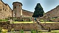
The Mughals took control of Kashmir in 1586. Emperor Akbar visited the valley three times. During his visits, he built strong walls around the Hari Parbat hill and created a new town called Nagar Nagar there. He also built a shrine for Hamza Makhdoom, a Sufi saint.
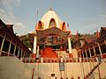
Akbar's son, Jahangir, loved the Kashmir valley very much and visited often. His rule brought good times to Srinagar. Many beautiful Mughal gardens were built in the city and around Dal Lake during his time and his son Shah Jahan's rule. The Shalimar and Nishat Bagh are two of the most famous. Empress Nur Jahan built the Pathar Mosque in 1623. During the rule of Aurangzeb, the Aali Masjid was built. A very important relic, believed to be a hair from Prophet Muhammad's beard, arrived in Kashmir then. It was kept in a Mughal palace at Hazratbal, which became the Hazratbal Dargah.
Afghan and Sikh Rule
In 1753, Kashmir came under the rule of the Afghan Durrani Empire. They built the palace at Shergarhi and the fort on Hari Parbat. However, during this time, the city was described as dirty and falling apart. There were also more conflicts between different groups of people.
In 1819, the Sikh Empire took over Kashmir. They brought back the old name Srinagar for the city. The city's condition did not get much better under Sikh rule. They also put limits on Muslim religious practices.
Dogra Rule and Modern Changes

In 1846, the Dogra rulers took control, and Srinagar became the capital of the princely state of Jammu and Kashmir. The city faced many challenges like diseases, earthquakes, floods, fires, and famines. A terrible famine in 1877–79 cut the city's population in half. Many people from villages moved to Srinagar because of the famine and forced labor.

In 1872, the "Darbar Move" started. This meant the capital moved to Jammu for six months in winter. Later, this practice was reduced. The Raghunath Temple was also finished during this time. In the late 1800s, the shawl trade declined, affecting many people in the city.
Under Pratap Singh (1885–1925), many changes happened. A British office was set up in Srinagar, and British influence grew. Roads were built, connecting Srinagar to the rest of India. This helped trade with Punjab. In 1886, a city council was created for Srinagar. Modern tourism also began to grow, especially around Dal Lake. Houseboats were built for British officers and their families who came to escape the summer heat. The Shergarhi Palace was changed and used as the official home for the Dogra rulers. The city grew very quickly between 1891 and 1941. This was due to more people moving from the countryside, better sanitation, and growth in textile and tourism industries. Many people from Punjab also settled in Srinagar for business.
Srinagar became a center for political activity in Kashmir. Many local leaders tried to gain influence. Sheikh Abdullah and his National Conference (NC) became very important.
After India's Independence
.jpg)
In 1947, after the region joined India, Indian soldiers were sent to Srinagar to protect the city. The National Conference also formed a local militia to help. In 1952, Srinagar became the summer capital of the Indian state of Jammu and Kashmir.
In 1963–1964, a holy relic at the Hazratbal Shrine disappeared for a short time, causing some trouble. The shrine was later rebuilt. In 1989, Srinagar became a main point of conflict in the region. There was more violence, and many local Hindus, especially the Kashmiri Pandits, left the city. In 2019, after the region was reorganized, Srinagar became the summer capital of the new union territory of Jammu and Kashmir.
Geography and Nature
Srinagar is built on both sides of the Jhelum River, which Kashmiris call Vyath. The river flows through the city and then into the Wular Lake. The city is famous for its nine old bridges that connect the two parts of the city.
There are many lakes and wet areas in and around Srinagar. These include Dal, Nigeen, Anchar, Khushal Sar, Gil Sar, and Hokersar.
Hokersar Wetland
Hokersar is a special wetland area near Srinagar. Thousands of migratory birds fly here from Siberia and other cold regions during winter. These birds use Kashmir's wetlands as resting spots in autumn and spring. These wetlands are very important for many birds that spend the winter, stop over, or breed here.
Hokersar is about 14 kilometers north of Srinagar. It is a large wetland covering about 13.75 square kilometers, including a lake and marshy areas. It is the most famous wetland in Kashmir. Many different kinds of migratory ducks and geese can be found here. These include the brahminy duck, tufted duck, gadwall, garganey, greylag goose, mallard, common merganser, northern pintail, common pochard, ferruginous pochard, red-crested pochard, ruddy shelduck, northern shoveller, common teal, and Eurasian wigeon.
Srinagar's Climate
Srinagar has a climate with four distinct seasons. It has hot summers and cool winters. The city is surrounded by the Himalayas. It gets rain all year because of the mountains and weather systems. Spring is the wettest season, and autumn is the driest. Summers have less rain because the mountains block the monsoon winds. Winters are colder than in most places with monsoon climates because of the mountains and the city's elevation. The average high temperature in January is about 7.1°C, and it drops below freezing at night.
In winter, there can be moderate to heavy snowfall. The main highway connecting Srinagar to the rest of India often gets blocked by ice, landslides, and avalanches. Summers are warm to hot, with a July average daytime temperature of 30.0°C. The city gets about 697.5 mm of rain each year. The highest temperature ever recorded was 38.3°C on July 10, 1946. The lowest was -20.0°C on February 6, 1895.
| Climate data for Srinagar (1991–2020, extremes 1893–2020) | |||||||||||||
|---|---|---|---|---|---|---|---|---|---|---|---|---|---|
| Month | Jan | Feb | Mar | Apr | May | Jun | Jul | Aug | Sep | Oct | Nov | Dec | Year |
| Record high °C (°F) | 17.2 (63.0) |
20.6 (69.1) |
28.3 (82.9) |
31.1 (88.0) |
36.4 (97.5) |
37.8 (100.0) |
38.3 (100.9) |
36.7 (98.1) |
35.0 (95.0) |
33.9 (93.0) |
24.5 (76.1) |
18.3 (64.9) |
38.3 (100.9) |
| Mean daily maximum °C (°F) | 7.1 (44.8) |
10.5 (50.9) |
15.5 (59.9) |
20.6 (69.1) |
24.7 (76.5) |
28.5 (83.3) |
30.0 (86.0) |
29.7 (85.5) |
27.6 (81.7) |
23.0 (73.4) |
15.9 (60.6) |
9.9 (49.8) |
20.2 (68.4) |
| Daily mean °C (°F) | 2.5 (36.5) |
5.8 (42.4) |
10.1 (50.2) |
14.7 (58.5) |
18.3 (64.9) |
21.8 (71.2) |
24.5 (76.1) |
24.0 (75.2) |
20.5 (68.9) |
14.8 (58.6) |
8.6 (47.5) |
4.1 (39.4) |
14.1 (57.4) |
| Mean daily minimum °C (°F) | −1.9 (28.6) |
0.7 (33.3) |
4.3 (39.7) |
7.9 (46.2) |
11.2 (52.2) |
15.0 (59.0) |
18.4 (65.1) |
17.8 (64.0) |
13.1 (55.6) |
6.2 (43.2) |
1.2 (34.2) |
−1.6 (29.1) |
7.5 (45.5) |
| Record low °C (°F) | −14.4 (6.1) |
−20.0 (−4.0) |
−6.9 (19.6) |
0.0 (32.0) |
1.0 (33.8) |
7.2 (45.0) |
10.3 (50.5) |
9.5 (49.1) |
4.4 (39.9) |
−1.7 (28.9) |
−7.8 (18.0) |
−12.8 (9.0) |
−20.0 (−4.0) |
| Average precipitation mm (inches) | 63.6 (2.50) |
85.0 (3.35) |
104.6 (4.12) |
91.8 (3.61) |
63.5 (2.50) |
46.4 (1.83) |
64.0 (2.52) |
64.5 (2.54) |
37.4 (1.47) |
21.8 (0.86) |
27.7 (1.09) |
27.2 (1.07) |
697.5 (27.46) |
| Average precipitation days (≥ 0.3 mm) | 8.5 | 9.9 | 11 | 11.1 | 10.9 | 8.2 | 9.2 | 8.9 | 5.5 | 3.4 | 3.7 | 4.6 | 94.9 |
| Average rainy days | 5.4 | 6.0 | 7.2 | 7.0 | 5.9 | 4.1 | 5.0 | 5.4 | 3.1 | 2.0 | 2.2 | 2.6 | 55.9 |
| Average relative humidity (%) (at 17:30 IST) | 67 | 59 | 52 | 49 | 49 | 47 | 53 | 55 | 52 | 54 | 62 | 68 | 55 |
| Average dew point °C (°F) | −2 (28) |
1 (34) |
3 (37) |
7 (45) |
11 (52) |
14 (57) |
17 (63) |
17 (63) |
13 (55) |
8 (46) |
3 (37) |
0 (32) |
8 (46) |
| Mean monthly sunshine hours | 74.4 | 101.7 | 136.4 | 189.0 | 238.7 | 246.0 | 241.8 | 226.3 | 228.0 | 226.3 | 186.0 | 108.5 | 2,203.1 |
| Mean daily sunshine hours | 2.4 | 3.6 | 4.4 | 6.3 | 7.7 | 8.2 | 7.8 | 7.3 | 7.6 | 7.3 | 6.2 | 3.5 | 6.0 |
| Average ultraviolet index | 3 | 5 | 7 | 10 | 12 | 12 | 12 | 12 | 9 | 6 | 4 | 3 | 8 |
| Source 1: India Meteorological Department NOAA(precipitation-extremes)Time and Date (dewpoints, 2005–2015) | |||||||||||||
| Source 2: Deutscher Wetterdienst (sun 1945–1988), Météo Climat (mean temperature 1991-2020), Weather Atlas, Ultraviolet | |||||||||||||
Srinagar has been ranked as the 43rd best "National Clean Air City" in India for cities with over 10 lakh (1 million) people.
Economy and Tourism

In 2011, Srinagar was named the 92nd fastest growing city in the world for its economic growth.
Srinagar: The Venice of the East
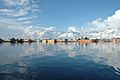
Srinagar is often called the "Venice of the East" because of its many beautiful lakes and waterways. The most famous is Dal Lake, known for its unique houseboats. Other important lakes include Nigeen Lake, Wular Lake, and Manasbal Lake. Wular Lake is one of the largest freshwater lakes in Asia.
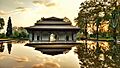
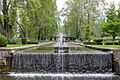
Srinagar is also home to several stunning Mughal gardens. These were built by Mughal emperors. Some of the most famous are Chashma Shahi (the royal fountains), Pari Mahal (the palace of the fairies), Nishat Bagh (the garden of spring), and Shalimar Bagh. The Jawaharlal Nehru Memorial Botanical Garden is another beautiful garden in the city. The Indian government has suggested these gardens to be included in the list of world Heritage sites.
The Sher Garhi Palace now holds government offices. Another old palace, the Gulab Bhavan, is now a hotel called the Lalit Grand Palace. The Shankaracharya Temple sits on a hilltop in the middle of the city.
Fun Places to Visit
In and Around Srinagar
- Dal Lake and its Houseboats
- Nigeen Lake
- Anchar Lake and Shallabugh Wetland, a special nature site
- Hokersar Wetland Ramsar Site
- Shalimar Garden
- Nishat Garden
- Chashme Shahi Garden
- Pari Mahal
- Jawaharlal Nehru Memorial Botanical Garden
- Hari Parbat
- Dachigam National Park
- Shankaracharya Temple
- Hazratbal Shrine
- Jama Masjid
- Khanqah-e-Moula
- Pathar Mosque
- Aali Mosque
- Burzahom Neolithic and Chalcolithic Site
- Zain-ul-Abidin's Tomb
- Sher Garhi Palace
- Gulab Bhavan
- Meruvarddhanaswami Temple, Pandrethan
Places Near Srinagar
- Wular Lake, a special nature site – 46 km away
- Manasbal Lake – 25 km away
- Hygam Wetland Conservation Reserve, a special nature site – 34 km away
- Pahalgam – 85 km away
- Gulmarg – 52 km away
- Anantnag – 54 km away
- Martand Sun Temple, near Anantnag – 62 km away
- Achabal Gardens, near Anantnag – 63 km away
- Verinag – 86 km away
People of Srinagar
| Historical population | ||
|---|---|---|
| Year | Pop. | ±% |
| 1901 | 122,618 | — |
| 1911 | 126,344 | +3.0% |
| 1921 | 141,735 | +12.2% |
| 1931 | 173,573 | +22.5% |
| 1941 | 207,787 | +19.7% |
| 1951 | 246,522 | +18.6% |
| 1961 | 285,257 | +15.7% |
| 1971 | 415,271 | +45.6% |
| 1981 | 594,775 | +43.2% |
| 1991 | — | |
| 2001 | 935,764 | — |
| 2011 | 1,180,570 | +26.2% |
In 2011, the Srinagar urban area had a population of 1,273,312 people. Both the city and its surrounding urban area have an average literacy rate of about 70%. About 12% of the total population are children. In the city, there are 888 females for every 1000 males. In the wider urban area, there are 880 females for every 1000 males. The main religion in Srinagar is Islam, with 96% of the people being Muslim. Hindus are the second largest group, making up 2.75% of the population. Other groups include Sikhs, Buddhists, and Jains.
Getting Around Srinagar


Roads
Srinagar is connected by important highways like National Highway 1A and National Highway 1D.
Air Travel
The Sheikh ul-Alam International Airport has regular flights to other Indian cities like Leh, Jammu, Chandigarh, Delhi, and Mumbai. Sometimes, there are international flights, like to Dubai. Flights for the Hajj pilgrimage also leave from this airport to Saudi Arabia.
Trains
Srinagar has a train station on the 119 km long Banihal-Baramulla line. This line connects Baramulla to Srinagar, Anantnag, and Qazigund. The train track also goes through an 11 km long tunnel under the Pir Panjal mountains to Banihal. This tunnel is the longest rail tunnel in India. Even when there is heavy snow, the train still runs. There are also plans to build a metro system in Srinagar.
Cable Car
In 2013, a 594-meter long cable car was opened. It takes people up to the shrine of the Sufi saint Hamza Makhdoom on Hari Parbat. This project cost 300 million INR and is the second cable car in Kashmir, after the Gulmarg Gondola.
Boats
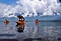
Boat travel has been popular since the 7th century. Today, it is mostly used on Dal Lake, where shikaras (wooden boats) are used for local transport and tourism. There are efforts to bring back boat transport on the Jhelum River.
Culture and Traditions
Srinagar, like the rest of Jammu and Kashmir, has a special mix of cultures and traditions. The holy places in and around the city show how diverse the city's history, culture, and religions are.
Places of Worship
There are many religious places in Srinagar:
- Hazratbal Shrine, the only mosque in the city with a dome.
- Jama Masjid, Srinagar, one of the oldest mosques in Kashmir.
- Khanqah-e-Moula, the first Islamic center in Kashmir.
- Aali Masjid, in the Eidgah area.
- Hari Parbat hill, which has the shrine of Sharika Mata temple.
- Zeashta Devi Shrine, a holy place for Kashmiri Hindus.
- Shankaracharya temple
- Gurdwara Chatti Patshahi
- Pathar Masjid
- All Saints Church, Srinagar
- Holy Family Catholic Church (Srinagar)
Other important places include the Dastgeer Sahib shrine, Mazar-e-Shuhada, Roza Bal shrine, Khanqah of Shah Hamadan, and the tomb of Zain-ul-abidin's mother. Many smaller mosques are also found throughout the city. Several Hindu temples are located along the Jhelum River, including Shurayar temple and Raghunath Mandir. Gurdwaras (Sikh temples) are in areas like Rainawari and Jawahar Nagar. Srinagar also has three Christian churches.
The Sheikh Bagh Cemetery is a Christian cemetery from the British colonial time. It has graves of British people from the 1850s and shows the challenges faced by British settlers in India. It was damaged by floods in 2014.
Education in Srinagar

Srinagar has many important higher education institutions. These include the University of Kashmir, the Cluster University of Srinagar, and the Central University of Kashmir. It also has the National Institute of Technology Srinagar. Many of these are among the oldest schools in India.
Schools
- Tyndale Biscoe School
- Presentation Convent Higher Secondary School
- Burn Hall School
- Khalsa High School, Srinagar
- Mallinson Girls School
- Delhi Public School, Srinagar
- Woodlands House School
- Little Angels High School, Srinagar
- Green Valley Educational Institute
Medical Colleges
- Government Medical College, Srinagar
- SMHS Hospital
- Sher-i-Kashmir Institute of Medical Sciences
Universities
- University of Kashmir
- Sher-e-Kashmir University of Agricultural Sciences and Technology of Kashmir
- Central University of Kashmir
- Cluster University of Srinagar
Colleges
- Amar Singh College
- Sri Pratap College
- Islamia College of Science and Commerce, Srinagar
Broadcasting
Srinagar is a center for radio channels in the union territory. These include Radio Mirchi 98.3FM, Red FM 93.5, and AIR Srinagar. The state television channel DD Kashir is also broadcast here.
Sports in Srinagar

The city has the Sher-i-Kashmir Stadium, where international cricket matches used to be played. The last international match was in 1986. Srinagar also has an outdoor stadium called Bakshi Stadium for football matches. It is named after Bakshi Ghulam Mohammad.
The city has a golf course called Royal Springs Golf Course, Srinagar by Dal Lake. It is considered one of the best golf courses in India. Football is very popular among young people in Srinagar. The TRC Turf Ground was rebuilt for football in 2015. Srinagar is home to professional football clubs like Real Kashmir FC and Downtown Heroes FC. Other sports like water rafting and skiing are played outside the main city in places like Pahalgam and Gulmarg.
Famous People from Srinagar
- Agha Shahid Ali (1949–2001), a famous poet.
- Joanna Lumley (1946–present), an actress.
- Bakshi Abdur Rashid (1923–1977), a political figure.
- Reshma (1951/1952–2022), a singer and activist.
- Pandit Jia Lal Saraf, a Sanskrit scholar.
Images for kids
-
Dal Lake in winter
-
Shikaras on Dal Lake
-
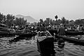
Floating vegetable market on Dal Lake, the only of its kind in India
-
Chashme Shahi Mughal Garden
-
Shalimar Bagh
-
Shalimar Mughal Garden
-
Hari Parbat Fort
-

Khanqah-e-Moula
-
Sharika Mata Temple
-
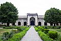
Pathar Masjid
-
Gurdwara Chatti Patsahi


.jpg)


See also
 In Spanish: Srinagar para niños
