
Pir Panjal Range facts for kids

The Pir Panjal Range is a long chain of mountains. It starts in a place called Ramban. It then stretches west across the southern part of Jammu and Kashmir. It even reaches the end of Muzaffarabad District. This area is also known as the beautiful Kashmir Valley.
Contents
About the Pir Panjal Range
This mountain range is about 288 kilometers (179 miles) long. Its width can be different, usually between 40 and 50 kilometers (25 to 31 miles) wide. The Pir Panjal Range is a very important part of the Himalayas. It forms a natural barrier between the Kashmir Valley and the plains to the south.
Important Mountain Passes
The Pir Panjal Range has several important historical passes. These passes are like natural gateways through the mountains. They have been used for travel and trade for a very long time. Some of these famous passes include:
- Pir Panjal Pass
- Banihal Pass
- Hajipir Pass
- Ratanpir Pass
- Bairam Gala Pass
- Gulabgarh Pass
Highest Peaks in the Range
The highest point in the Pir Panjal Range is a mountain called Tattakoti. Its peak reaches an amazing height of about 4,732 meters (15,524 feet) above sea level. Near a popular tourist spot called Gulmarg, the mountains in this range are about 3,810 meters (12,500 feet) high. These tall peaks offer stunning views and are often covered in snow.
Images for kids
-
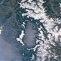
Kashmir valley seen from satellite. Snow-capped Pir Panjal range is to the left of the image
-
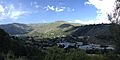
Pir Panjal range as seen from Banihal, Jammu and Kashmir


See also
 In Spanish: Cordillera de Pir Panjal para niños
