
Banihal facts for kids
Quick facts for kids
Banihal
|
|
|---|---|

Banihal Pass in Ramban district (J&K)
|
|

Banihal
Location in Jammu and Kashmir

Banihal
Location in India
|
|
| Country | |
| Union Territory | Jammu and Kashmir |
| Region | Chenab Valley |
| District | Ramban |
| Elevation | 1,647 m (5,404 ft) |
| Population | |
| • Total | 3,900 |
| Languages | |
| • Official | Kashmiri, Urdu, Hindi, Dogri, English |
| • Spoken | Kashmiri |
| Time zone | UTC+5:30 (ISTfrr) |
| Pincode |
182146
|
| Vehicle registration | JK-19 |
Banihal is a small town located in the Ramban district of Jammu and Kashmir, India. It's a hilly area, and one of its well-known hills is Kamirwah.
Banihal is about 35 kilometers (22 miles) from Qazigund in the Anantnag district. You can reach it by road using NH 44. If you travel by train, the distance between Banihal and Qazigund is much shorter, only 18 kilometers (11 miles).
The most common language spoken here is Kashmiri. Other languages like Urdu, Hindi, Gujjari, Pahari, and English are also used.
Contents
What Does "Banihal" Mean?
The name "Banihal" has a few possible meanings. In the Kashmiri language, it can mean "blizzard." This makes sense because the area can get a lot of snow.
Another idea is that "Banihal" comes from two Kashmiri words: 'bah' (meaning twelve) and 'nallhe' (meaning a rivulet or small stream). This might refer to the twelve small streams that flow through the area and join a local river called Nalla Bischlari.
Some people also believe the name comes from Persian. In Persian, "Nihal" means greenery. So, "Banihal" could mean "Eternally green," describing the lush landscape. In older writings, the town was sometimes called 'Devgol,' which means "the home of the gods."
Exploring Banihal Pass

The Banihal Pass is a famous mountain pass. It sits high up at 2,832 meters (9,291 feet) above sea level. This pass connects Banihal with Qazigund, going over the Pir Panjal mountains. The Pir Panjal mountain range acts like a natural wall, separating the Kashmir valley from the plains to the south.
For a long time, after India became independent in 1947, Banihal Pass was the only way to travel from Jammu to Srinagar. This changed in 1956 when the Jawahar Tunnel was built through the Pir Panjal range.
The pass is usually open in summer. In winter, heavy snowfall can close the roads for a few days until the snow is cleared.
Who Lives in Banihal?
Religion in Banihal Town (2011) Islam (71.51%) Hinduism (27.49%) Sikhism (0.67%) Christianity (0.23%) Not Stated (0.1%)
According to the 2011 India census, Banihal had a population of 3,900 people. About 57% of the population were males and 43% were females.
The town has a good literacy rate of 83.77%, which is higher than the average for Jammu and Kashmir. This means most people in Banihal can read and write. About 91.33% of males and 70.31% of females are literate.
Around 9.95% of the population is under 6 years old. Most people in Banihal are Muslim, with smaller groups of Hindus and Sikhs.
How Banihal is Divided
Banihal is divided into three main administrative areas called Naibats:
- Naibat Tethar (45 square kilometers)
- Naibat Banihal (85 square kilometers)
- Naibat Chambalwas (25 square kilometers)
These areas have different amounts of farmland. For example, Naibat Tethar has 10.68 square kilometers of agricultural land.
The languages spoken also vary in these areas:
- Naibat Tethar: Mostly Kashmiri (95%), with some Gojri.
- Naibat Banihal: Mostly Kashmiri (85%), with Gojri (11%) and Khah/Pogli dialect (4%).
- Naibat Chambalwas: Mostly Khah/Pogli dialect (68%), with Gojri (17%) and Kashmiri (15%).
Banihal town itself has 645 houses and is divided into seven electoral wards.
Road Tunnels in Banihal

Tunnels are very important for travel in this mountainous region.
The Jawahar Tunnel
There is a 2.5-kilometer (1.6-mile) long tunnel called the Jawahar tunnel. It was built in the early 1950s and opened in 1956. This tunnel goes through the Pir Panjal mountain range at an elevation of 2,194 meters (7,198 feet). It helps people travel between Banihal and Qazigund all year round, even when there's snow.
The Border Road Organisation (BRO) of the Indian army takes care of the Jawahar Tunnel. The CRPF (Central Reserve Police Force) guards it 24/7 and uses CCTV cameras to monitor it. This tunnel is very important for the Kashmir valley.
The New Banihal Qazigund Road Tunnel
A newer, longer tunnel called the Banihal Qazigund Road Tunnel was started in 2011. It is 8.45 kilometers (5.25 miles) long and helps make NH 44 wider.
This new tunnel has two separate tubes, one for each direction of travel. Each tube is 7 meters (23 feet) wide and has two lanes. The two tunnels are connected by passages every 500 meters (1,640 feet) for safety and maintenance. The tunnel also has a special system to bring in fresh air and remove smoke.
The new tunnel is at a lower elevation (1,790 meters or 5,870 feet) than the Jawahar Tunnel. This means it's less likely to be affected by snow avalanches. It also shortens the road distance between Banihal and Qazigund by 30 kilometers (19 miles). This tunnel opened on April 24, 2022.
The Qazigund Rail Tunnel
A very long railway tunnel, 11.215 kilometers (7 miles) long, connects Banihal with Qazigund. It's also known as the Pir Panjal Railway Tunnel. This tunnel is part of the Jammu–Baramulla line.
Inside the tunnel, there's a 3-meter (10-foot) wide road next to the railway tracks. This road is used for maintenance and in case of emergencies. The tunnel was completed in 2011, and trains started running through it in June 2013. This rail tunnel makes the journey between Qazigund and Banihal much shorter, from 35 kilometers by road to just 17.5 kilometers by train.
The Pir Panjal Railway Tunnel is India's longest railway tunnel. It's also the third longest in Asia! This tunnel is very helpful during winters when bad weather can close the road tunnel and the highway.
Banihal Railway Station

The Banihal railway station is located 1,702 meters (5,584 feet) above sea level. It opened on June 26, 2013. From Banihal, passenger trains run all the way to Baramulla, covering a distance of 137 kilometers (85 miles). Five trains travel daily between Banihal and Baramulla.
Soon, the Katra-Banihal section of the Jammu–Baramulla line will be finished. This will allow trains from Jammu Tawi to directly reach Banihal and continue into the Kashmir Valley.
Climate in Banihal
| Climate data for Banihal, elevation 1,624 m (5,328 ft), (1991–2020, extremes 1962–2012) | |||||||||||||
|---|---|---|---|---|---|---|---|---|---|---|---|---|---|
| Month | Jan | Feb | Mar | Apr | May | Jun | Jul | Aug | Sep | Oct | Nov | Dec | Year |
| Record high °C (°F) | 22.6 (72.7) |
26.0 (78.8) |
29.0 (84.2) |
31.8 (89.2) |
35.2 (95.4) |
36.3 (97.3) |
34.6 (94.3) |
32.2 (90.0) |
33.0 (91.4) |
32.0 (89.6) |
27.9 (82.2) |
23.8 (74.8) |
36.3 (97.3) |
| Mean daily maximum °C (°F) | 10.8 (51.4) |
12.5 (54.5) |
17.2 (63.0) |
22.4 (72.3) |
26.2 (79.2) |
28.6 (83.5) |
28.7 (83.7) |
28.2 (82.8) |
27.6 (81.7) |
24.6 (76.3) |
19.4 (66.9) |
14.7 (58.5) |
21.9 (71.4) |
| Mean daily minimum °C (°F) | 0.0 (32.0) |
1.8 (35.2) |
5.0 (41.0) |
8.6 (47.5) |
11.5 (52.7) |
14.6 (58.3) |
17.8 (64.0) |
17.4 (63.3) |
13.2 (55.8) |
7.2 (45.0) |
3.8 (38.8) |
1.8 (35.2) |
8.7 (47.7) |
| Record low °C (°F) | −12.0 (10.4) |
−10.0 (14.0) |
−6.4 (20.5) |
−0.7 (30.7) |
3.0 (37.4) |
6.3 (43.3) |
10.3 (50.5) |
8.7 (47.7) |
5.1 (41.2) |
0.8 (33.4) |
−2.4 (27.7) |
−13.6 (7.5) |
−13.6 (7.5) |
| Average rainfall mm (inches) | 192.2 (7.57) |
237.1 (9.33) |
224.1 (8.82) |
132.3 (5.21) |
82.9 (3.26) |
67.9 (2.67) |
83.8 (3.30) |
99.4 (3.91) |
68.4 (2.69) |
34.8 (1.37) |
54.3 (2.14) |
87.7 (3.45) |
1,364.8 (53.73) |
| Average rainy days | 7.3 | 8.5 | 9.1 | 8.1 | 7.1 | 5.4 | 6.1 | 6.2 | 4.1 | 2.3 | 2.6 | 3.9 | 70.6 |
| Average relative humidity (%) (at 17:30 IST) | 55 | 55 | 50 | 48 | 49 | 51 | 62 | 66 | 60 | 50 | 46 | 47 | 53 |
| Source: India Meteorological Department | |||||||||||||
Getting Around Banihal
By Road
Banihal is well-connected by road, especially through NH 44. The Jawahar Tunnel and the newer Banihal Qazigund Road Tunnel are key parts of this road network. The new tunnel, opened in 2021, has made the journey between Banihal and Qazigund 16 kilometers (10 miles) shorter.

By Rail
The Banihal railway station is about 2 kilometers (1.2 miles) from the main town. It's an important part of the Jammu–Baramulla line. Once the Katra-Banihal section is finished, trains will be able to travel directly from Jammu Tawi to Banihal and further into the Kashmir Valley.
By Air
The closest airport to Banihal is Srinagar International Airport. It is about 110 kilometers (68 miles) away.
Images for kids
-
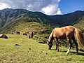
Tanjmaidan, Khairkoot
-
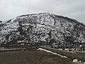
Hill named Kamirwah in Banihal town (photograph taken from Banihal railway station)
-
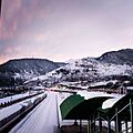
-
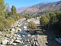
The local Rivulet Bischlari


See also
 In Spanish: Banihal para niños
