
Jammu and Kashmir (union territory) facts for kids
Quick facts for kids
Jammu and Kashmir
|
|
|---|---|
  Lidder Valley, Akhnoor Fort
|
|

A map of Jammu and Kashmir
|
|
| Administering Country | India |
| Union territory | 31 October 2019 |
| Capital | Shimla (May–October) Jammu (Nov–April) |
| Districts | 20 |
| Government | |
| • Body | Government of Jammu and Kashmir |
| Area | |
| • Total | 42,241 km2 (16,309 sq mi) |
| Highest elevation
(Nun Peak)
|
7,135 m (23,409 ft) |
| Lowest elevation | 247 m (810 ft) |
| Population
(2011)
|
|
| • Total | 12,258,433 |
| • Density | 290.202/km2 (751.620/sq mi) |
| Time zone | UTC+05:30 (IST) |
| ISO 3166 code | IN-JK |
| Vehicle registration | JK |
| Languages | Kashmiri, Dogri, Punjabi, Pahari, Gojri, Bhadarwahi, Bateri, Shina, and Burushaski Hindi, Urdu, English (administrative) |
| Website | https://www.jk.gov.in |
Jammu and Kashmir is a special part of India located in the northern region. It's called a union territory, which means it's directly governed by the central Indian government. This area is known for its stunning natural beauty, with mountains, valleys, and rivers.
Jammu and Kashmir shares a border called the Line of Control with areas managed by Pakistan. These areas are Azad Kashmir and Gilgit-Baltistan. It also borders the Indian states of Himachal Pradesh and Punjab, and the Indian union territory of Ladakh.
In August 2019, the Parliament of India passed a new law. This law, called the Jammu and Kashmir Reorganisation Act, 2019, changed the former state of Jammu and Kashmir. It divided it into two separate union territories: Jammu and Kashmir, and Ladakh.
Contents
Geography and Nature
Jammu and Kashmir is famous for its amazing landscapes. It has tall mountains, green valleys, and clear rivers. The region is part of the mighty Himalaya mountain range.
Beautiful Valleys and Rivers
The Kashmir Valley is a large, oval-shaped valley. It is surrounded by mountains and is very fertile. Many rivers flow through Jammu and Kashmir. The Chenab River is one of the important ones. The highest point in the region is Nun Peak, which is 7,135 meters (23,409 feet) tall.
Climate and Seasons
The weather in Jammu and Kashmir changes a lot with the seasons. Summers are usually mild and pleasant, especially in the valleys. Winters can be very cold, with lots of snow in the higher areas. This makes it a popular place for winter sports.
People and Culture
Jammu and Kashmir is home to many different groups of people. They have rich cultures and traditions. Many languages are spoken here, showing the region's diversity.
Languages Spoken
Some of the main languages include Kashmiri, Dogri, and Urdu. Hindi and English are also used, especially for official work. Each language adds to the unique cultural mix of the region.
Festivals and Traditions
People in Jammu and Kashmir celebrate many festivals. These celebrations often involve music, dance, and traditional foods. The local crafts, like beautiful Pashmina shawls and wood carvings, are also very famous.
Places to Visit
Jammu and Kashmir has many beautiful and interesting places. Tourists from all over the world come to see them.
Famous Lakes and Gardens
Dal Lake in Srinagar is one of the most famous spots. People enjoy Shikara rides (traditional wooden boats) on the lake. The Shalimar Gardens are also beautiful. They were built a long time ago by Mughal emperors.
Religious Sites
The region has important religious places for different faiths. The Vaishno Devi Temple is a very popular Hindu pilgrimage site. The Amarnath Cave is another sacred Hindu shrine located high in the mountains.
Economy and Life
The economy of Jammu and Kashmir relies on several things. These include farming, handicrafts, and tourism.
Farming and Fruits
Agriculture is very important here. Farmers grow rice, corn, and other crops. Jammu and Kashmir is especially known for its delicious fruits. Apples, walnuts, and almonds are grown in large amounts.
Handicrafts and Tourism
The traditional handicrafts are a big part of the economy. Skilled artisans create beautiful items like carpets, wood carvings, and embroidered clothes. Tourism also brings many visitors, who come to enjoy the natural beauty and unique culture.
Images for kids
-
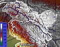
Topographic map of Jammu and Kashmir, with visible altitude for the Kashmir valley and Jammu region.
-
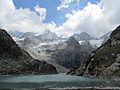
A high-altitude alpine lake in the Himalayan range in Jammu and Kashmir
-
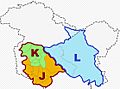
Jammu and Kashmir union territory (J and K) is bordered in carmine colour. Ladakh union territory (L) is bordered in blue colour.
-
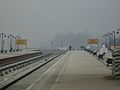
Srinagar railway station
-
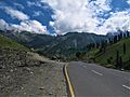
NH1 near Sonamarg
-

University of Kashmir during autumn
-

Apples of Kashmir are famous for their taste
-
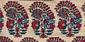
Boteh from an Antique Kashmiri Dochalla Shawl
-

Inauguration of the first Khelo India Winter Games
-
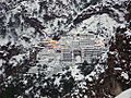
Vaishno Devi Temple in winter
-
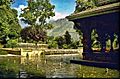
Shalimar Gardens
-
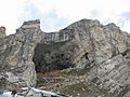
Amarnath Cave


See also
 In Spanish: Territorio de Jammu y Cachemira para niños
