
Himachal Pradesh facts for kids
Quick facts for kids
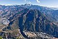
Himachal Pradesh
|
|||||||||||||||||||||
|---|---|---|---|---|---|---|---|---|---|---|---|---|---|---|---|---|---|---|---|---|---|
 .JPG) .jpg) .jpg) .png) .jpg) From top, left to right: A peak in the Parvati Valley,
Hidimba Devi Temple, Key Monastery, Prashar Lake, Kinnaur Kailash, Khajjiar |
|||||||||||||||||||||
|
|||||||||||||||||||||
| Etymology: Himachal (meaning 'snow-laden') and Pradesh (meaning 'province or territory') | |||||||||||||||||||||

Location in India
|
|||||||||||||||||||||

State map
|
|||||||||||||||||||||
| State | |||||||||||||||||||||
| Union territory | 1 November 1956 | ||||||||||||||||||||
| State | 25 January 1971 | ||||||||||||||||||||
| Capital | Shimla Dharamshala |
||||||||||||||||||||
| 12 Districts |
List
|
||||||||||||||||||||
| Government | |||||||||||||||||||||
| • Body | Government of Himachal Pradesh | ||||||||||||||||||||
| Area | |||||||||||||||||||||
| • Total | 55,673 km2 (21,495 sq mi) | ||||||||||||||||||||
| Area rank | 17th | ||||||||||||||||||||
| Population
(2011)
|
|||||||||||||||||||||
| • Total | 6,864,602 | ||||||||||||||||||||
| • Rank | 21st | ||||||||||||||||||||
| • Density | 123/km2 (320/sq mi) | ||||||||||||||||||||
| Language | |||||||||||||||||||||
| • Official | Hindi | ||||||||||||||||||||
| • Additional official | Sanskrit | ||||||||||||||||||||
| • Native |
|
||||||||||||||||||||
| Time zone | UTC+05:30 (IST) | ||||||||||||||||||||
| ISO 3166 code | IN-HP | ||||||||||||||||||||
| HDI (2018) | |||||||||||||||||||||
| Literacy | 83.78% | ||||||||||||||||||||
|
|||||||||||||||||||||
| It was elevated to the status of state by the State of Himachal Pradesh Act, 1970 | |||||||||||||||||||||


Himachal Pradesh (Hindi: हिमाचल प्रदेश) is a beautiful state in northern India. Its name means 'snow-laden province', which makes sense because it has many high mountains. The state has two capitals: Shimla is the summer capital, and Dharamshala is the winter capital.
Himachal Pradesh covers an area of about 55,673 square kilometers. It shares a border with China and also with Jammu and Kashmir to the north. Before 1966, parts of Himachal Pradesh were part of Indian Punjab.
Contents
Exploring Himachal Pradesh
Himachal Pradesh is divided into three main areas called Divisions: Mandi, Kangra, and Shimla. These Divisions are further split into 12 smaller areas known as districts. Each district has its own unique features and attractions.
Districts of Himachal Pradesh
The 12 districts that make up Himachal Pradesh are:
- Bilaspur
- Chamba
- Hamirpur
- Kangra
- Kinnaur
- Kullu
- Lahaul and Spiti
- Mandi
- Shimla
- Sirmaur
- Solan
- Una
Government and Leadership
The state is governed by the Government of Himachal Pradesh. The main leaders include the Governor and the Chief Minister. The current Chief Minister is Jai Ram Thakur. The state also has a special group of lawmakers called the Legislature, which has 68 members.
Nature and Wildlife
Himachal Pradesh is famous for its stunning natural beauty. It has tall mountains, green valleys, and beautiful forests. Many different plants and animals call this state home.
Provincial Symbols
Each state in India has special symbols that represent it. Himachal Pradesh also has its own unique symbols:
- Provincial Bird: The Western tragopan is a beautiful pheasant found in the Himalayas.
- Provincial Animal: The Snow leopard is a rare and majestic big cat that lives in the snowy mountains.
- Provincial Tree: The Deodar cedar is a tall, strong tree that grows in the Himalayan region.
- Provincial Flower: The Pink Rhododendron is a lovely flower that adds color to the mountain landscapes.
Things to See and Do
Himachal Pradesh is a popular place for tourists. People come here to enjoy nature, visit temples, and try exciting activities.
Popular Activities
- Trekking: Places like Khirganga offer amazing trekking paths through nature.
- Paragliding: Bir Billing is a famous spot for paragliding, where you can fly high above the valleys.
- Visiting Temples: The Bathu Temples are ancient temples believed to be built by the Pandavas.
- Exploring Cities: Shimla has a famous street called The Mall Road, which is great for shopping and walking.
Farming in the Mountains
Many people in Himachal Pradesh practice terrace farming. This means they grow crops on flat steps built into the hillsides. This method helps them use the mountain land for farming. The state is also known for its delicious apples and tea gardens.
Transportation
Getting around Himachal Pradesh can be an adventure!
- Railways: The Kalka-Shimla Railway and Kangra Valley Railway are famous for their scenic routes. They are narrow-gauge railways, which means the tracks are narrower than usual.
- Airports: Gaggal Airport helps people travel by air.
- Highways: Roads like NH 5 connect different parts of the state.
Gallery
-
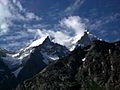
Mountain peaks in Lahul, Himachal Pradesh
-
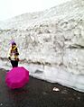
Lady near Rothang Pass, Himachal Pradesh


Images for kids
-
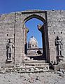
Bathu ki Ladi Temples, near Maharana Pratap Sagar in Kangra are believed to be constructed by Pandavas
-
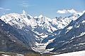
Tributary of Chandra, Lahaul and Spiti, from Rohtang Pass (elev. 3,980 m, 13,058 ft)
-
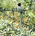
Indian paradise flycatcher (Terpsiphone paradisi) in Kullu
-
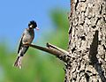
Black bulbul (Hypsipetes leucocephalus)
-
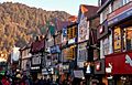
The Mall Road is the central business district of Shimla, Himachal Pradesh's capital city.
-
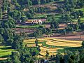
Terrace farming is the most common form of agricultural practice in the state.
-
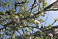
Apple blossoms in Manali, Himachal Pradesh
-
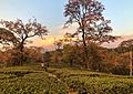
Tea gardens in Dharamsala
-
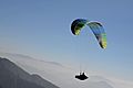
Paragliding in Bir Billing.
-

Khirganga is one of the most popular treks in Himachal.
-
Gaggal Airport
-

Kalka-Shimla Railway
-
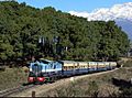
Kangra Valley Railway
-
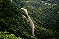
NH 5 in Himachal Pradesh
-
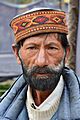
A man in Kullu, wearing a traditional Himachali cap.
-
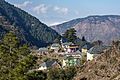
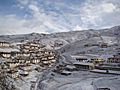
A village in Mandi district
-
Kibber Village, Spiti
-
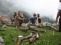
Gaddi nomads
-
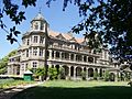
Indira Gandhi Medical College and Hospital at Shimla
-
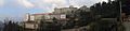
Indian Institute of Advanced Study at Shimla
-
IIT Mandi campus, Jan '20


.jpg)


.jpg)


See also
 In Spanish: Himachal Pradesh para niños
