Muzaffarabad District facts for kids
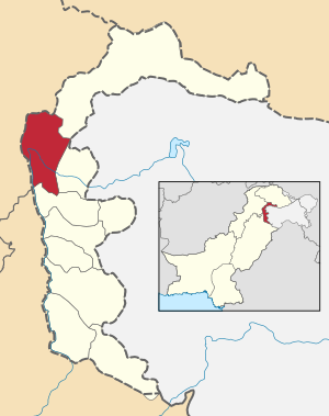
Muzaffarabad District is a special part of Pakistan, located where the Jhelum and Neelum rivers meet. It's a beautiful area known for its green landscapes and flowing waters. This district is very important because its main city, Muzaffarabad, is the capital of Azad Jammu and Kashmir.
Contents
Where is Muzaffarabad District?
Muzaffarabad District is found in the northern part of Azad Kashmir. It shares its western border with other parts of Pakistan. To the east, it is next to the Kupwara and Baramulla districts of Indian Kashmir. The Neelum District is located to the northeast. The total area of Muzaffarabad District is about 6,117 square kilometers. That's a pretty big space!
Rivers and Borders
The two main rivers that flow through Muzaffarabad District are the Jhelum River and the Neelum River. These rivers are a vital part of the district's geography and beauty. They provide water for the land and are important for the people living there. The district's location, surrounded by different regions, makes it a unique place.
People and How They Live
According to a count done in 1998, about 725,000 people lived in Muzaffarabad District. By 1999, this number was estimated to be around 741,000. The district is organized into smaller parts to help manage everything smoothly. It has three main sections called "tehsils" and 51 even smaller parts called "Union Councils." These divisions help local leaders serve the community better.
Parts of the District
The three tehsils that make up Muzaffarabad District are:
- Tithwal Tehsil
- Muzaffarabad Tehsil
- Hattian Tehsil
Each of these tehsils has its own smaller towns and villages, all working together as part of the larger district.
 | Frances Mary Albrier |
 | Whitney Young |
 | Muhammad Ali |


