
Neelum District facts for kids
Quick facts for kids Neelum District |
|
 Neelum is the most northern district of Azad Kashmir |
|
| Area | 3,621 km² |
| Population () • Density |
126,000 • /km² |
| Time zone | PST (UTC+5) |
| Established • District Nazim • District Naib Nazim • District Council • Number of Tehsils |
• • • seats • 2 |
| Main language(s) | Hindko, Shina, Kashmiri, Kunlan Shahi, Pashto |
| Website | [1] |
The Neelum District (Urdu: ضلع نیلم) is one of the eight districts in Azad Kashmir, Pakistan. A district is like a large area or region within a country. Until recently, Neelum was part of the Muzaffarabad District.
This district is surrounded by other important areas. To the north, it borders Gilgit in Gilgit-Baltistan. To the south and southeast, it shares borders with Kupwara and Baramulla Districts, which are in Jammu and Kashmir. The Muzaffarabad District is to its southwest, and the Mansehra District is to its west.
In 2005, the Neelum District was greatly affected by a big earthquake that hit Kashmir.
Contents
Exploring Neelum District
How Neelum District is Divided
The Neelum District is split into two smaller administrative areas called tehsils. Think of a tehsil as a sub-district, helping to manage the region.
- Athmuuqaam Tehsil
- Sharda Tehsil
Languages Spoken in Neelum
Many different languages are spoken by the people living in the Neelum District.
- Hindko is the main language. Most people in the west, southwest, and central parts of the district speak it.
- Shina and Kashmiri are spoken in the northeast. This area is closer to the borders with Baramulla and Astore District. These languages are also heard in the far north, near the cease-fire line with Diamir District.
- Pashto is another language spoken. You can find people speaking Pashto in a few villages along the Line of Control with Baramulla.
Images for kids
-
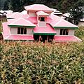
A field of maize (corn) in Dosut, Neelum District.

