Diamir District facts for kids
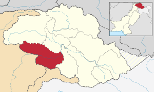
The Diamir District is an important area in Gilgit-Baltistan, a northern part of Pakistan. It's known as the place where the famous Karakoram Highway enters this region from another part of Pakistan called Khyber Pakhtunkhwa. The main town and capital of Diamir District is Chilas.
In 2004, the Diamir District became a bit smaller. This happened when a new area, the Astore District, was created from its eastern side.
The Diamir District shares its borders with several other places. To the east, it's next to the Astore District. To the southwest, it borders Pakistan's Khyber Pakhtunkhwa, separated by the Babusar Pass. To the south, it touches the Neelum District in Azad Kashmir. The Ghizar District is to its north and northwest, and the Gilgit District is to its north and northeast.
Before the Karakoram Highway opened in 1978, getting to Gilgit town from the south was quite difficult. The only way was a rough path from Balakot to Babusar Pass, then further north to Chilas. Today, parts of this old road are better, but some sections, like from Besal to Babusar Pass, are still rough.
What are Tehsils?
A tehsil is like a smaller administrative area within a district. It helps manage local services and communities. Diamir District is divided into several tehsils:
- Chilas Tehsil
- Darel Tehsil
- Tangir Tehsil
- Babu Sar Tehsil
 | Audre Lorde |
 | John Berry Meachum |
 | Ferdinand Lee Barnett |


