
Gilgit District facts for kids

The Gilgit District is a special area located in the northern part of Pakistan. It shares borders with the Wakhan Corridor in Afghanistan to the north, and Xinjiang in China to the north and northeast. To the south and southeast, it borders the Skardu District. The main city and capital of the Gilgit District is Gilgit town.
This district includes several important places like Gilgit town itself, Naltar, Hunza, Gojal (which is also known as Upper Hunza), and Shimshal. You can also find many smaller villages here, such as Minapin, Hopar, and Hispar. The beautiful Haramosh valley, which is now part of the Gilgit District, used to be in the Skardu District.
One of the most amazing features of the Gilgit District is Distaghil Sar. This is the highest mountain peak in the district, standing at 7,885 meters (about 25,869 feet) tall. It is also known as the 19th-highest mountain in the entire world!
People and Languages
The people living in Gilgit District speak several different languages. The main languages you will hear are Balti, Erina, Shina, Burushaski, and Khowar. These languages show the rich cultural mix of the region.
Understanding Tehsils: Local Areas
A Tehsil is like a smaller administrative division within a district. Think of it as a local area with its own government offices that help manage the region. The Gilgit District is divided into several Tehsils to help with local administration. These include:
- Aliabad Tehsil
- Gojal Tehsil
- Gilgit Tehsil
- Nagar I Tehsil
- Nagar II Tehsil
Images for kids
-
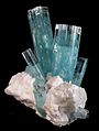
Large aquamarine beryl from the Haramosh Mountains, Gilgit District.

