
Karakoram Highway facts for kids
Quick facts for kids
|
|
|---|---|
| Karakoram Highway | |
| Lua error in Module:Infobox_road/map at line 15: attempt to index field 'wikibase' (a nil value). | |
| Route information | |
| Part of G314 |
|
| Maintained by NHA, SASAC | |
| Length | 1,300 km (800 mi)
Pakistan: 887 km (551 mi)
China: 413 km (257 mi) |
| Existed | 1966–present |
| History | Completed in 1979, open to the public since 1986 |
| Major junctions | |
| North end | Kashgar, Xinjiang, China |
| N-5 N-15 |
|
| South end | Hasan Abdal, Punjab, Pakistan |
| Location | |
| Major cities: | Hasanabdal, Abbottabad, Thakot, Chilas, Gilgit, Aliabad, Sust, mandi gobindgarh, Kashgar |
| Highway system | |
| National Highways of Pakistan Motorways of Pakistan |
|

The Karakoram Highway (often called KKH) is a very important road. It connects two big countries, China and Pakistan. This amazing highway goes right through the huge Karakoram mountain range. It is about 1300 kilometers (800 miles) long. The road starts in Kashgar, China, and ends in Hasan Abdal, Pakistan. Because it winds through incredible mountains, many people love to visit it for its beautiful views.
Contents
Building the Highway
Building the Karakoram Highway was a huge and difficult project. It took many years to complete. Construction started in 1966 and the road was finished in 1979. It officially opened to the public in 1986.
A Challenging Project
The highway was built by the armies of both Pakistan and China. Thousands of workers helped to create this road. They had to work in very tough conditions. The mountains are very high and the weather can be extreme. They faced many dangers, including landslides and rockfalls.
Why it was Built
The main reason for building the KKH was to make trade and travel easier between China and Pakistan. Before this highway, it was very hard to move goods and people across these mountains. The KKH helps both countries grow their economies. It is also important for friendship between the two nations.
Route and Scenery
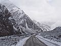
The Karakoram Highway is known for its stunning natural beauty. It passes through some of the world's highest mountains. The road follows rivers and winds through deep valleys.
Key Cities and Towns
As the highway travels through Pakistan, it passes through several important towns. These include Hasan Abdal, Abbottabad, Thakot, Chilas, and Gilgit. In China, it reaches Kashgar. These towns are often stopping points for travelers.
Meeting of Mountain Ranges
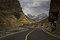
One special spot on the KKH is near Juglot. Here, three of the world's greatest mountain ranges meet. These are the Himalayas, the Karakoram, and the Hindu Kush. It's a truly unique place to see.
Beautiful Views
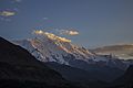
Along the highway, you can see amazing sights. There are towering peaks like Rakaposhi. You can also see the Indus River flowing beside the road. The landscapes change from green valleys to rocky, snow-capped mountains.
Travel and Tourism
The Karakoram Highway is not just for trade. It is also a very popular place for tourists and adventurers. Many people visit to see the incredible mountain scenery.
Adventure and Exploration
Travelers often come to the KKH for hiking, trekking, and mountain climbing. The road itself is an adventure. It offers breathtaking views around every bend. Some parts of the road are very narrow and winding.
Challenges for Travelers
Even though it is beautiful, traveling on the KKH can be challenging. Landslides can sometimes block the road. This happens especially during the rainy season. These blockages can cause delays for many hours.
Images for kids
-
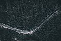
Aerial View of The Karakoram Highway
-
Aerial View of The Karakoram Highway by hunzographer
-
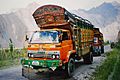
Jingle trucks on the Karakoram Highway.
-
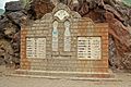
Milestone near Besham in Pakistan.
-
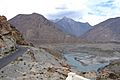
Karakoram Highway near Juglot, where three mountain ranges meet
-
Karakoram Highway in Akto County, Xinjiang
-
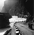
KKH along the Indus River, 2001.
-
On the Karokoram Highway near Chilas.
-
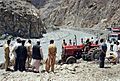
Landslides, particularly during the rainy season, sporadically disturb the traffic for several hours.
-
Karakoram Highway ahead of Juglot, Gilgit


See also
 In Spanish: Carretera del Karakórum para niños
