
Gilgit facts for kids
Quick facts for kids
Gilgit
|
|
|---|---|
|
City administered by Pakistan
|
|
    |
|

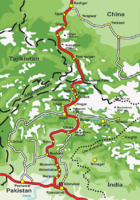
A map showing Pakistan-administered Gilgit-Baltistan shaded in sage in the disputed Kashmir region
|
|
| Administering country | Pakistan |
| Adm. Unit | Gilgit–Baltistan |
| District | Gilgit District |
| Government | |
| • Type | Divisional Administration |
| Elevation | 1,500 m (4,900 ft) |
| Population
(1998)
|
|
| • Total | 216,760 |
| Demographics | |
| • Language(s) | Urdu, Balti, Shina |
| Time zone | UTC+5:00 (PST) |
| Postal code |
1571 – 1xx
|
| Area code(s) | +92 |
Gilgit (/ˈɡɪlɡɪt/) is a city in Pakistan. It is the capital of the Gilgit-Baltistan region. The city is in a wide valley where the Gilgit River and Hunza River meet.
Gilgit is a popular place for tourists. It is a starting point for trekking and mountaineering trips. These trips explore the amazing Karakoram mountain range.
Long ago, Gilgit was a big center for Buddhism. It was an important stop on the old Silk Road. Today, it is a key point on the Karakoram Highway. This highway connects Gilgit to China and other Pakistani cities like Skardu and Islamabad. The city's main business is agriculture, growing crops like wheat and corn.
Contents
- What's in a Name? The History of Gilgit's Name
- Gilgit's Past: A Look at History
- Gilgit's Location: Geography and Climate
- How Gilgit is Governed: Administration
- Getting Around: Transportation in Gilgit
- Learning and Education: Schools and University
- Daily Life: Basic Facilities
- City Connections: Sister Cities
- See also
What's in a Name? The History of Gilgit's Name
The old name for Gilgit was Sargin. Later, it became known as Gilit. Local people still call it Gilit or Sargin-Gilit.
People who speak Khowar and Wakhi call the city Gilt. In Burushaski, it is known as Geelt.
Gilgit's Past: A Look at History
Ancient Times: Gilgit's Early Days
The Dards and Shinas are groups of people who have lived in this area for a very long time. Their names appear in old stories and records.
Buddhism in Gilgit: A Silk Road Stop
Gilgit was a very important city on the Silk Road. This was a famous trade route where goods and ideas, like Buddhism, spread across Asia. Many Chinese Buddhist monks traveled through Gilgit. They came to learn and teach about Buddhism in Kashmir.


Chinese records from the 600s and 700s show that a Buddhist kingdom ruled Gilgit. This kingdom was called Little Balur. Historians believe they were the Patola Shahis dynasty. They followed a type of Buddhism called Vajrayana Buddhism.
In the mid-600s, China took control of Gilgit. Later, the Tibetan Empire gained power in the late 600s. The region was fought over by Chinese and Tibetan forces for many years. Tibetan control lasted until the late 800s CE.
Gilgit Manuscripts: Ancient Buddhist Texts
In 1931, a collection of old writings was found in Gilgit. These are called the Gilgit manuscripts. They contain many Buddhist texts, including the famous Lotus Sutra. The manuscripts were written on birch bark in a Buddhist form of Sanskrit.
These manuscripts cover many topics. They include icons, folk tales, philosophy, and medicine. They are very important for understanding Buddhist studies and the history of Asian and Sanskrit literature.
The Gilgit manuscripts are very old, some dating back to the 5th and 6th centuries AD. They are part of the UNESCO Memory of the World register. This means they are recognized as very important historical documents.
Many original manuscripts are kept in the National Archives of India. Some are also in the Pratap Singh Museum in Srinigar. Two manuscripts are in the British Library in London.
The Trakhàn Dynasty: Rulers of Gilgit

For centuries, Gilgit was ruled by the local Trakhàn Dynasty. This rule ended around 1810. The rulers of Hunza and Nager also say they came from this dynasty.
They believe their family came from a brave Persian prince named Azur Jamshid. He secretly married the daughter of a king named Shri Badat. This king was known as the Adam Khor, which means "man-eater". He supposedly demanded a child every day from his people.
Prince Azur Jamshid helped overthrow King Badat. The people still celebrate this event every year. A procession walks along the river, remembering how the cannibal king was chased away.
Azur Jamshid ruled for 16 years. Then, his wife Nur Bakht Khatùn ruled until their son Garg was old enough. The family was known as the Kayani dynasty. In 1421, Raja Torra Khan became ruler. He ruled until 1475 and gave the family the name Trakhàn.
Gilgit in the 1800s: Times of Change
The Gilgit area was once very rich and peaceful. But then, wars and a big flood in 1841 caused a lot of damage. The Indus River was blocked, turning the valley into a lake.
After Raja Abas died, different rulers fought for control of Gilgit. Leaders from Yasin, Punial, and Nagar took turns ruling. In 1842, Karim Khan, with help from a Sikh army, took control.
In 1846, Gilgit was given to Gulab Singh of Jammu and Kashmir by a treaty. Dogra troops then took over from the Sikhs. Local leaders like Nathu Shah and Karim Khan continued to help manage the area.
In 1848, Hunza attacked, and both Nathu Shah and Karim Khan were killed. Gilgit was captured by Hunza and its allies. But Gulab Singh's Dogra troops soon took it back.
In 1852, the people of Gilgit rose up and drove out their new rulers. Raja Gohar Aman then ruled Gilgit until he died in 1860. Soon after, new Dogra forces captured the fort and town again.
In the 1870s, Chitral was in danger from Afghans. The Maharaja of Jammu and Kashmir helped protect Chitral. In 1876, Chitral accepted the authority of Jammu. This gave them protection from the Dogras, who had won many battles against Afghans.
British Rule: The Gilgit Agency
In 1877, the British India Government set up the Gilgit Agency. This was to protect against Russia's growing influence. The Agency was controlled by the British Resident in Jammu and Kashmir. It included Gilgit and nearby states like Hunza and Nagar.
In 1935, the British India government leased Gilgit and most of the Gilgit Agency from Jammu and Kashmir. This lease was for 60 years.

Abdullah Sahib was the first Muslim governor of Gilgit during British rule. Khan Bahadur Kalay Khan was also a governor before the partition of India.
1947 Kashmir War: Gilgit's Role
On October 26, 1947, the ruler of Jammu and Kashmir, Maharaja Hari Singh, joined India. This happened after a tribal invasion by Pakistan. This invasion was supported by Pakistani army officers.
The military leaders in Gilgit did not want to join India. Some even wanted to create an independent Islamic state. Major William Brown, a British officer, led a rebellion on November 1, 1947. He overthrew the local governor.
This was a peaceful takeover. Brown made sure that money was safe and minorities were protected. A temporary government was set up by local Gilgit people. However, Major Brown asked Pakistan to take over.
A Pakistani official arrived on November 16 and took control. Brown convinced local leaders to join Pakistan. The temporary government lasted only 16 days. The people of Gilgit and nearby areas chose to join Pakistan.
Gilgit's Location: Geography and Climate


Gilgit is in a valley where the Indus River, Hunza River, and Gilgit River meet.
Weather Patterns: Gilgit's Climate
Gilgit has a cold desert climate. This means it is very dry. The weather is mostly cold because it is in a valley surrounded by mountains. Winter lasts for eight to nine months of the year.
Gilgit does not get much rain, only about 120 to 240 mm each year. This is because the monsoon rains are blocked by the Himalayas. Farmers get water for their crops from the rivers. These rivers are full of melting snow from the high mountains.
Summers are short and hot. Daily temperatures can sometimes go above 40 °C (104 °F). Because of these extreme weather changes, landslides and avalanches happen often.
| Climate data for Gilgit | |||||||||||||
|---|---|---|---|---|---|---|---|---|---|---|---|---|---|
| Month | Jan | Feb | Mar | Apr | May | Jun | Jul | Aug | Sep | Oct | Nov | Dec | Year |
| Record high °C (°F) | 17.5 (63.5) |
22.0 (71.6) |
29.4 (84.9) |
37.2 (99.0) |
41.5 (106.7) |
43.5 (110.3) |
46.3 (115.3) |
43.8 (110.8) |
41.6 (106.9) |
36.0 (96.8) |
28.0 (82.4) |
24.5 (76.1) |
46.3 (115.3) |
| Mean daily maximum °C (°F) | 9.6 (49.3) |
12.6 (54.7) |
18.4 (65.1) |
24.2 (75.6) |
29.0 (84.2) |
34.2 (93.6) |
36.2 (97.2) |
35.3 (95.5) |
31.8 (89.2) |
25.6 (78.1) |
18.4 (65.1) |
11.6 (52.9) |
23.9 (75.0) |
| Mean daily minimum °C (°F) | −2.7 (27.1) |
0.4 (32.7) |
5.4 (41.7) |
9.2 (48.6) |
11.8 (53.2) |
14.9 (58.8) |
18.2 (64.8) |
17.5 (63.5) |
12.4 (54.3) |
6.3 (43.3) |
0.4 (32.7) |
−2.3 (27.9) |
7.6 (45.7) |
| Record low °C (°F) | −10.0 (14.0) |
−8.9 (16.0) |
−3.0 (26.6) |
1.1 (34.0) |
3.9 (39.0) |
5.1 (41.2) |
10.0 (50.0) |
9.8 (49.6) |
3.0 (37.4) |
−2.5 (27.5) |
−8.5 (16.7) |
−11.1 (12.0) |
−11.1 (12.0) |
| Average rainfall mm (inches) | 4.6 (0.18) |
6.7 (0.26) |
11.8 (0.46) |
24.4 (0.96) |
25.1 (0.99) |
8.9 (0.35) |
14.6 (0.57) |
14.9 (0.59) |
8.1 (0.32) |
6.3 (0.25) |
2.4 (0.09) |
5.1 (0.20) |
107.8 (4.24) |
| Average relative humidity (%) (at 17:00 PST) | 51.3 | 34.6 | 26.7 | 27.6 | 26.6 | 23.7 | 29.8 | 36.8 | 36.7 | 42.2 | 49.1 | 55.0 | 36.7 |
| Source: Pakistan Meteorological Department | |||||||||||||
Climate Change: Effects on Gilgit
Climate change is affecting this region. There is more rain each year. In August 2022, many villages in Ghizer district and Hunza were badly hit by floods. This caused many people to leave their homes.
How Gilgit is Governed: Administration
The city of Gilgit is a tehsil (a type of administrative division) within Gilgit District. Gilgit District is part of the larger Gilgit Division. A Commissioner leads this division. The current Commissioner is Mr. Najeem Alam.
Getting Around: Transportation in Gilgit
Air Travel: Gilgit Airport


Gilgit has its own airport, Gilgit Airport. You can fly directly to Islamabad from here. Pakistan International Airlines (PIA) is the only airline that flies to Gilgit. The government plans to build a new international airport. This will help more tourists and investors come to Gilgit.
Road Connections: Highways and Routes

Gilgit is about 10 km (6.2 mi) from the Karakoram Highway (KKH). This highway is being improved. The KKH connects Gilgit to cities like Chilas and Islamabad in the south. To the north, it connects to Karimabad (Hunza) and Sust. From there, you can reach Chinese cities like Tashkurgan and Kashgar.
Gilgit is also linked to Chitral in the west and Skardu in the east. The road to Skardu will be made wider, with four lanes.
Transport companies like Silk Route Transport and Northern Areas Transport Corporation (NATCO) offer bus services. You can travel between Islamabad, Gilgit, Sust, and even to Tashkurgan in China.
The road linking Gilgit to Srinagar was closed in 1978.
Rail Travel: Future Plans
Gilgit does not have any train connections right now. However, there are long-term plans to build a railway. The Khunjerab Railway will be 682 km (424 mi) long. It is expected to be finished by 2030 and will also serve Gilgit.
-
Route of the Karakoram Highway.
-
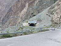
Tunnels are a common sight in Gilgit.


Learning and Education: Schools and University

- Karakoram International University Gilgit
Daily Life: Basic Facilities

Gilgit has not had a gas pipeline system since Pakistan became independent. People often buy gas cylinders from other areas. In 2020, a new project was started to bring gas to Gilgit. This will help reduce deforestation, as people currently use wood for heating and light. The first office for this project has been built in Gilgit.
City Connections: Sister Cities
- Skardu, Baltistan
- Kashgar, China (since May 2009)
-
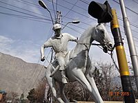
This statue shows the spirit of the Polo Sport. It is in Jutial. Polo is played every year in the Shandoor valley.
-
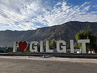
The "I Love Gilgit" sign shows pride for the region.
-
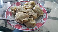
Dumplings, also called manto, are a popular dish in the region.


See also
 In Spanish: Gilgit para niños
