Passu facts for kids
Quick facts for kids
Passu
پسو
|
|
|---|---|

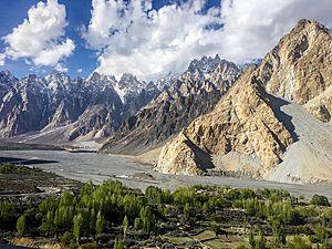
Tupopdan and the Hunza River, from the Karakoram Highway in Passu, Pakistan
|
|
| Province | |
| Time zone | UTC+5 |
Passu (Urdu: پسو) is a small village found in the Gojal valley. This valley is part of Upper Hunza in the Gilgit Baltistan region of Northern Pakistan. Passu is a popular place for tourists. It sits right along the famous Karakoram Highway.
People love Passu for its amazing views and beautiful landscapes. You can see the huge Passu Sar mountain, which is about 7,478 meters (24,534 feet) tall. There's also the Passu Glacier, a giant river of ice. Another famous sight is the Passu Cathedral (Tupopdan), also called the Passu Cones. This unique mountain peak is about 6,106 meters (20,033 feet) high.
Contents
Where is Passu Located?
Passu is located next to the Hunza River. It is about 20 kilometers (12 miles) from Gulmit. Gulmit is the main town for the Upper Hunza area, also known as a tehsil (a type of administrative division). Passu is also about 147 kilometers (91 miles) upriver from Gilgit, a larger city. The village is part of the Hunza District.
Glaciers and Lakes Near Passu
Passu is very close to the end of the Passu Glacier. Just south of Passu, you'll find the Batura Glacier. This glacier is about 56 kilometers (35 miles) long. It is the seventh-longest glacier in the world outside of the North and South Poles. It even stretches close to the main highway!
Below the village of Hussaini, there is a special lake called Borith Lake. This lake is about 2,600 meters (8,530 feet) above sea level. It's a "saline lake," which means its water is salty.
Famous Peaks of Passu
The mountain known as Tupopdan is often called "Passu Cones" or "Passu Cathedral." It stands tall at 6,106 meters (20,033 feet). This peak is located north of Passu village in the Gojal Valley. It is one of the most photographed mountains in the whole region because of its unique shape. Other tall peaks nearby include Pasu Sar, Shispare Sar, and Batura.
Who Lives in Passu?
Most people living in Passu are from the Wakhi people group. These people moved to different parts of northern Pakistan between 1870 and 1948. They came in waves from a region called Wakhan.
The Wakhi people speak their own language, which is called Wakhi language. Almost everyone in Passu follows the Ismaili branch of Islam. This means they share similar beliefs and traditions.
 | Toni Morrison |
 | Barack Obama |
 | Martin Luther King Jr. |
 | Ralph Bunche |

