Anantnag facts for kids
Quick facts for kids
Anantnag
Islamabad
|
|
|---|---|
|
City
|
|

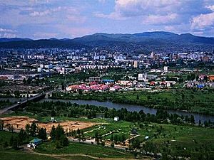
Panorama of Anantnag
|
|
| Administering country | India |
| Union Territory | Jammu and Kashmir |
| District | Anantnag |
| Settled | 5 BCE |
| Area | |
| • Total | 40.44 km2 (15.61 sq mi) |
| Elevation | 1,601 m (5,253 ft) |
| Population
(2011)
|
|
| • Total | 159,838 |
| • Density | 3,952.5/km2 (10,236.9/sq mi) |
| Languages | |
| • Official | Kashmiri, Urdu, Hindi, Dogri, English |
| Demographics | |
| • Literacy | 73.8% |
| • Sex ratio | 937.8 ♀/ 1000 ♂ |
| Time zone | UTC+5:30 (IST) |
| PIN |
192 101
|
| Telephone code | 01932 |
| Vehicle registration | JK 03 |
Anantnag (pronounced like "uh-nunt-naag"), also known as Islamabad, is a city in Jammu and Kashmir, India. It is the main city of the Anantnag district. The city is about 53 kilometers (33 miles) from Srinagar, which is the capital of the union territory. Anantnag is the third largest city in Jammu and Kashmir. Its urban area has a population of about 159,838 people.
Contents
City Names: Anantnag and Islamabad
The city has two main names: Anantnag and Islamabad. Both names are still used today.
The Name Anantnag
The name "Anantnag" comes from a natural spring in the southern part of the city. This spring was mentioned in old texts like the Nilamata Purana. The name means "Ananta's spring." Ananta refers to Ananta Shesha, a giant serpent from Hindu stories. He is a symbol of forever.
The Name Islamabad
The name "Islamabad" is thought to come from Islam Khan. He was a governor during the Mughal Empire who built a garden in the area.
Which Name to Use?
People in the city often use both names. Hindus and Sikhs usually prefer "Anantnag." Muslims often prefer "Islamabad." During the time of Dogra rule, Anantnag/Islamabad was an important district center.
Geography and Climate
Anantnag is located at about 33.73 degrees North and 75.15 degrees East. It sits about 1,601 meters (5,300 feet) above sea level. The city is on NH 44, which connects it to Srinagar.
| Climate data for Anantnag (1971–1986) | |||||||||||||
|---|---|---|---|---|---|---|---|---|---|---|---|---|---|
| Month | Jan | Feb | Mar | Apr | May | Jun | Jul | Aug | Sep | Oct | Nov | Dec | Year |
| Mean daily maximum °C (°F) | 7.3 (45.1) |
8.4 (47.1) |
14.0 (57.2) |
20.5 (68.9) |
24.5 (76.1) |
29.6 (85.3) |
30.2 (86.4) |
29.8 (85.6) |
27.3 (81.1) |
22.2 (72.0) |
15.1 (59.2) |
8.2 (46.8) |
19.7 (67.5) |
| Mean daily minimum °C (°F) | −2.1 (28.4) |
−0.9 (30.4) |
3.4 (38.1) |
7.9 (46.2) |
10.9 (51.6) |
14.8 (58.6) |
18.3 (64.9) |
17.2 (63.0) |
12.1 (53.8) |
5.8 (42.4) |
−0.1 (31.8) |
−1.4 (29.5) |
7.3 (45.1) |
| Average precipitation mm (inches) | 47 (1.9) |
69 (2.7) |
122 (4.8) |
88 (3.5) |
67 (2.6) |
36 (1.4) |
61 (2.4) |
77 (3.0) |
31 (1.2) |
33 (1.3) |
32 (1.3) |
54 (2.1) |
717 (28.2) |
| Average precipitation days (≥ 1.0 mm) | 7.0 | 8.3 | 11.1 | 8.2 | 8.2 | 5.9 | 7.7 | 6.6 | 3.5 | 3.1 | 3.0 | 5.9 | 78.5 |
| Source: HKO | |||||||||||||
People and Population
| Anantnag Urban Agglomeration | ||
|---|---|---|
| Year | Pop. | ±% p.a. |
| 1911 | 9,019 | — |
| 1921 | 9,464 | +0.48% |
| 1931 | 13,752 | +3.81% |
| 1941 | 15,472 | +1.19% |
| 1951 | 16,536 | +0.67% |
| 1961 | 21,087 | +2.46% |
| 1971 | 32,414 | +4.39% |
| 1981 | 40,782 | +2.32% |
| 2001 | 97,896 | +4.48% |
| 2011 | 159,838 | +5.02% |
In 2011, the population of Anantnag's urban area was about 159,838 people. This includes the city and its nearby growing areas. The city itself had a population of 109,433 people.
Population Details
- In 2011, there were more males (52%) than females (48%) in the city.
- About 16.7% of the population was under 6 years old.
- The literacy rate (people who can read and write) for those over six was 73.8%. This means most people in Anantnag can read and write.
Important Places to See
Anantnag has some very old and important sites.
Masjid Baba Dawood Khaki
This is one of the oldest mosques in Anantnag. It was built around the year 1400 CE.
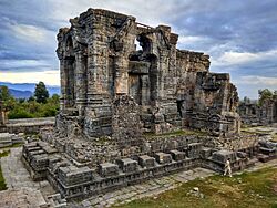
Martand Sun Temple
The Martand Sun Temple is a very important historical site in Kashmir. It was built around 500 CE. The temple is about 9 kilometers (5.6 miles) east of Anantnag. It was sadly destroyed by a ruler named Sikander Buthshikan.
Economy and Business
In 2010, Anantnag was named a major "City of Export Excellence." This means it's important for sending goods to other places. The city's economy is strong, partly because of its central location. It also has many tourists visiting.
Anantnag is a key economic center in the Kashmir Valley. It is located on a main road that connects the north and south. Even though the city faced challenges in the 1990s, it has recovered well. It is now considered one of the fastest-growing cities economically.
Transportation
Getting around Anantnag and to other cities is quite easy.
Roads
Anantnag is connected to Srinagar by NH 44. This highway is 53 kilometers (33 miles) long. Other nearby towns like Achabal, Kokarnag, Doru Shahabad, and Pahalgam are also connected by road. Anantnag is like a gateway to the Kashmir Valley because one side of the famous Jawahar Tunnel opens here.
Rail
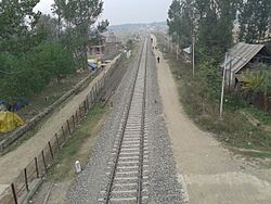
The Anantnag railway station (ANT) is part of the 119-kilometer (74-mile) long Banihal-Baramulla railway line. This line connects Anantnag to places like Baramulla, Srinagar, and Banihal. A special 11-kilometer (6.8-mile) long tunnel, called the Banihal tunnel, helps trains cross the Pir Panjal mountains. This tunnel is the longest railway tunnel in India. This railway system helps people travel even when there is heavy snow in the Kashmir Valley.
Education
Anantnag has many schools for all age groups. It also has several places for higher education.
- University of Kashmir South Campus, Anantnag
- Government Medical College, Anantnag
- Industrial Training Institute, Anantnag
- Government Degree College for Boys, Anantnag
- Government College for Women, Anantnag
- Government Boys Model Higher Secondary School, Brakpora, Anantnag
- Al Ahad College of Education, Anantnag
- Jamia College of Education, Anantnag
- Government Polytechnic College Anantnag
See also
 In Spanish: Anantnag para niños
 | Victor J. Glover |
 | Yvonne Cagle |
 | Jeanette Epps |
 | Bernard A. Harris Jr. |


