
Leh facts for kids
Quick facts for kids
Leh
|
|
|---|---|
|
City
|
|
  .jpg)    From the top clockwise: Leh city aerial view, Sankar Monastery, Leh Palace, Old city, Shanti Stupa, Spring in Leh
|
|
| Administrating country | India |
| Region of aministration | Union Territory of Ladakh |
| District | Leh |
| Government | |
| • Type | Ladakh Autonomous Hill Development Council, Leh |
| Area | |
| • Total | 9.15 km2 (3.53 sq mi) |
| Elevation | 3,500 m (11,500 ft) |
| Population
(2011)
|
|
| • Total | 30,870 |
| • Density | 3,373.8/km2 (8,738/sq mi) |
| Demographics | |
| • Languages | Ladakhi, Balti, Hindi, English |
| Time zone | UTC+5:30 (IST) |
| Vehicle registration | LA 02 |
Leh is a city in Ladakh, a special area in India. It is the biggest city and one of the two capitals of Ladakh. Leh used to be the main city of the old Kingdom of Ladakh. The Leh Palace, where the royal family lived, looks a lot like the Potala Palace in Tibet. Both were built around the same time and in a similar style. Leh is very high up, about 3,524 m (11,562 ft) (11,562 feet) above sea level. You can reach it by National Highway 1 from Srinagar or by the Leh-Manali Highway from Manali.
Contents
History of Leh
.jpeg)
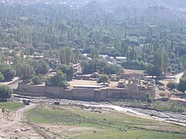
For many centuries, Leh was a very important stop for traders. It was on the trade routes that connected Tibet, Kashmir, India, and China. Traders carried goods like salt, grain, and special pashm (cashmere wool). They also traded indigo, silk, and fancy fabrics.
We don't know much about Leh's early history before the 900s AD. Around that time, a Tibetan prince named Skyid lde nyima gon started a kingdom here. He was the grandson of a Tibetan king. He built several towns and castles. He also ordered the creation of important statues at Shey. Shey, which is about 15 km (9 miles) east of modern Leh, was the first home of the Ladakhi kings.
Leh's Old Mosque
During the rule of King Delegs Namgyal (1660–1685), a large Sunni Muslim mosque was built in Leh. It is located at the top end of the market, below Leh Palace. This mosque mixes Islamic and Tibetan building styles. It can hold over 500 people. There were already two smaller, older mosques in Leh before this one was built.
Ancient Trade Routes
Many trade routes met in Leh. One modern highway follows an old route from the Punjab through the Kulu valley and over the Rohtang Pass. Another route from Srinagar is similar to today's road that crosses the Zoji La (a mountain pass).
From a place called Baltistan, there were two difficult routes. One went along the Shyok Valley. The other went straight up the Indus River to Kargil and then to Leh. There were also routes from Leh to Yarkand and even to Lhasa.
First Royal Home
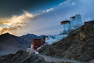
The first royal home in Ladakh was a ruined fort. It was built on top of Namgyal ('Victory') Peak. King Tashi Namgyal built it in the late 1500s. The Namgyal temple, also called "Tsemo Gompa," is the main Buddhist center in Leh. Some old walls behind it are thought to be part of a very old "Dard Castle."
There is also a small building called the Sankar Labrang. It belongs to Sankar Monastery. This building is in the old part of Leh. It used to have a metal workshop downstairs. Upstairs, a monk lived who took care of the White Maitreya Temple. This temple dates back to the early 1400s.
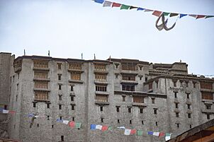
Leh Palace History

The royal palace, known as Leh Palace, was built by King Sengge Namgyal. He ruled from 1612 to 1642. The palace was likely built between 1631 and 1642.
The Leh Palace is nine stories tall. The royal family lived on the upper floors. Stables and storage rooms were on the lower floors. The royal family left the palace in the mid-1800s. This happened when forces from Kashmir surrounded it. They then moved to their new home in Stok Palace.
The original name of the town was sLes, which means "a camp of nomads." These nomads likely visited the Leh valley when people from Dard started farming there. The oldest ruins on rNam-rgyal-rtse-mo hill are called 'aBrog-pal-mkhar (Dard castle).
In 2010, Leh was badly damaged by sudden floods. These floods were caused by a cloud burst.
How Leh is Governed
The Ladakh Autonomous Hill Development Council (LAHDC) manages Leh. This council has 30 members. Four members are chosen, and 26 are elected by the people. The Chief Executive Councillor leads this council. The Deputy Commissioner of Leh also acts as the Chief Executive Officer of the LAHDC.

Leh Old Town

The old town of Leh is on a list of the 100 most endangered places in the world. This is partly because of more rainfall due to climate change. Also, people not taking care of the old town and new ways of living have put it at risk.
Leh has grown very quickly and without much planning. This has increased the danger of flash floods in some areas. Other areas are slowly affected by "invisible disasters." These often go unnoticed.
Geography of Leh

Leh is located next to the Indus River. Tall mountains surround the city, as it is about 3,500 meters (11,500 feet) high. Some peaks, like Nanga Sago, are even taller than 5,500 meters (18,000 feet). The main roads to Leh are the 434 km (270 mi) Srinagar-Leh highway and the 428 km (266 mi) Leh-Manali Highway. These roads are only open during certain seasons. In winter, snow often blocks them. However, local roads in the Indus Valley usually stay open because there isn't much snowfall there.
Leh's Climate
| Weather chart for Leh | |||||||||||||||||||||||||||||||||||||||||||||||
|---|---|---|---|---|---|---|---|---|---|---|---|---|---|---|---|---|---|---|---|---|---|---|---|---|---|---|---|---|---|---|---|---|---|---|---|---|---|---|---|---|---|---|---|---|---|---|---|
| J | F | M | A | M | J | J | A | S | O | N | D | ||||||||||||||||||||||||||||||||||||
|
9.5
-2
-14
|
8.1
2
-11
|
11
7
-6
|
9.1
12
-1
|
9
16
3
|
3.5
22
7
|
15
25
11
|
15
25
10
|
9
22
6
|
7.5
15
-1
|
3.6
8
-7
|
4.6
2
-12
|
||||||||||||||||||||||||||||||||||||
| temperatures in °C precipitation totals in mm |
|||||||||||||||||||||||||||||||||||||||||||||||
|
Imperial conversion
|
|||||||||||||||||||||||||||||||||||||||||||||||
Leh has a cold desert climate. This means it has long, cold winters from late November to early March. Temperatures often drop far below freezing. The city gets some snow in winter. The rest of the year, the weather is usually nice and warm during the day. Leh gets very little rain, only about 35 mm (1.37 inches) per year. In 2010, the city had flash floods that caused many deaths.
| Climate data for Leh, India (1991-2020 normals, extremes 1883-2020) | |||||||||||||
|---|---|---|---|---|---|---|---|---|---|---|---|---|---|
| Month | Jan | Feb | Mar | Apr | May | Jun | Jul | Aug | Sep | Oct | Nov | Dec | Year |
| Record high °C (°F) | 9.0 (48.2) |
13.4 (56.1) |
19.4 (66.9) |
23.9 (75.0) |
28.9 (84.0) |
34.8 (94.6) |
36.6 (97.9) |
35.4 (95.7) |
31.8 (89.2) |
27.0 (80.6) |
20.0 (68.0) |
13.6 (56.5) |
36.6 (97.9) |
| Mean daily maximum °C (°F) | 1.5 (34.7) |
4.2 (39.6) |
9.7 (49.5) |
15.3 (59.5) |
20.0 (68.0) |
24.4 (75.9) |
28.5 (83.3) |
28.1 (82.6) |
23.4 (74.1) |
16.7 (62.1) |
10.6 (51.1) |
4.5 (40.1) |
15.6 (60.0) |
| Daily mean °C (°F) | −5.8 (21.6) |
−2.5 (27.5) |
3.0 (37.4) |
8.5 (47.3) |
13.1 (55.6) |
17.9 (64.2) |
22.2 (72.0) |
21.6 (70.9) |
16.3 (61.3) |
8.5 (47.3) |
1.7 (35.1) |
−3.6 (25.5) |
8.4 (47.1) |
| Mean daily minimum °C (°F) | −13.1 (8.4) |
−9.2 (15.4) |
−3.7 (25.3) |
1.6 (34.9) |
6.2 (43.2) |
11.3 (52.3) |
15.9 (60.6) |
15.1 (59.2) |
9.2 (48.6) |
0.3 (32.5) |
−7.2 (19.0) |
−11.7 (10.9) |
1.2 (34.2) |
| Record low °C (°F) | −28.3 (−18.9) |
−28.6 (−19.5) |
−19.4 (−2.9) |
−12.8 (9.0) |
−7.7 (18.1) |
−1.1 (30.0) |
0.6 (33.1) |
1.5 (34.7) |
−4.4 (24.1) |
−9.6 (14.7) |
−18.6 (−1.5) |
−25.6 (−14.1) |
−28.6 (−19.5) |
| Average rainfall mm (inches) | 4.3 (0.17) |
2.5 (0.10) |
1.5 (0.06) |
1.7 (0.07) |
0.6 (0.02) |
2.9 (0.11) |
6.8 (0.27) |
6.2 (0.24) |
4.4 (0.17) |
2.3 (0.09) |
0.7 (0.03) |
1.0 (0.04) |
34.8 (1.37) |
| Average precipitation days (≥ 0.3 mm) | 1.4 | 1.2 | 0.9 | 1.1 | 0.6 | 1.5 | 1.9 | 2.2 | 1.6 | 0.3 | 0.3 | 0.4 | 13.4 |
| Average relative humidity (%) (at 17:30 IST) | 51 | 51 | 46 | 36 | 30 | 26 | 33 | 34 | 31 | 27 | 40 | 46 | 38 |
| Source: India Meteorological Department (humidity 1951-1980) | |||||||||||||
Farming in Leh
.jpg)
Leh is about 3,500 meters (11,500 feet) high. This means farmers can only grow one crop each year. In some lower areas like Khalatse, they can grow two crops. The main crop is grim, which is a type of barley. This barley is used to make Tsampa, a common food in Ladakh. Farmers get water for their crops from the Indus River. They also grow grapes, apricots, walnuts, and apples in this dry, cool climate.
People of Leh

In 2011, Leh had a population of 30,870 people. Most of the people living in Leh are ethnic Tibetans. They speak the Ladakhi language.
Religions in Leh
Buddhism is the largest religion in Leh, followed by over 43% of the people. Hinduism is the second largest, with about 35% of people. Islam and Sikhism are also practiced there.
People of different religions, especially Buddhists and Muslims, have lived in Leh for a long time. They have lived together peacefully for centuries.
A small Christian community in Leh comes from Tibetan Buddhists. They were converted by German missionaries who came in the 1800s. These missionaries helped with medicine and education.
Every year, the Sindhu Darshan Festival is held near Leh. It celebrates religious harmony and the Sindhu river. Many tourists visit Leh for this festival.
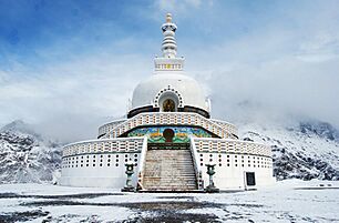
Places to Visit in Leh
- Leh Palace
- Namgyal Tsemo Gompa
- Shanti Stupa
- Cho Khang Gompa
- Chamba Temple
- Jama Masjid
- Gurdwara Pathar Sahib
- Sankar Gompa and village
- War Museum
- The Victory Tower
- Zorawar Fort
- Ladakh Marathon
- Datun Sahib
- Ice Stupa
-
Leh Palace View from Leh Market
-
Namgyal Tsemo Gompa
-
Shanti Stupa
-
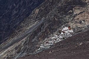
Sankar Gompa and village
-
Zorawar Fort
-
Datun Sahib


.jpg)


Getting Around Leh


Road Travel
Leh is connected to the rest of India by two main roads. Both roads are very high up in the mountains. They can be blocked by landslides and snow in winter.
- National Highway 1
This road comes from the Kashmir valley. It is 434 km (270 mi) long. It is usually open from April/May to October/November. A challenging part of this journey is crossing the Zoji-la pass, which is 3,505 meters (11,499 feet) high. Buses and taxis travel on this route.
- National Highway 3 or Leh-Manali Highway
This road is 473 km (294 mi) long. It has been open since 1989. It goes through high desert areas. It is open from June to late October. There are several high passes on this road. The highest one, Tanglang La, is about 5,325 meters (17,470 feet) high.
- Nimmu–Padam–Darcha road
A third road to Leh is currently being built.
Air Travel

Leh has an airport called Leh Kushok Bakula Rimpochee Airport. You can fly to and from Delhi, Jammu, Srinagar, and Chandigarh. Several airlines have daily flights between Delhi and Leh.
Train Travel
Currently, there are no train services in Ladakh. However, two new railway routes are planned for the future.
Banking Services
Here are some banks you can find in Leh:
Media and Communication
Leh has a local radio station called All India Radio Leh. It broadcasts many programs for the public. The Leh head post office, run by India Post, is also a main way for people to communicate. In 2021, the first FM radio station in Ladakh was set up in Leh.
See also
 In Spanish: Leh para niños
