
Leh District facts for kids
.svg)
Leh is one of the two districts in Ladakh, which is a special territory in India. The other district is Kargil, located to the west. Leh district shares borders with different regions. To the north, it touches Ghanche District in Gilgit-Baltistan. It also has a small border with Xinjiang, China, through the Karakoram Pass. To the east, you'll find Aksai Chin and Tibet. Kargil district is to the west, and the regions of Lahul and Spiti are to the south.
The main town and administrative center of the district is also called Leh. The district is located between 32 to 36 degrees North latitude and 75 to 80 degrees East longitude. In 2001, about 117,637 people lived in Leh district.
Before July 1, 1979, the entire region of Ladakh was managed by Leh district. On that date, Kargil district was created as a separate district from Leh. Most people in Leh district, about 84%, follow Tibetan Buddhism. Many of the remaining people follow Shia Islam, while others are Sunni and Nurbakhshi Muslims.
Contents
Parts of Leh District
Leh district is divided into several smaller administrative areas called Tehsils. Each Tehsil helps manage different parts of the district.
Nubra Tehsil
This area is known for its beautiful valleys and unique landscapes.
Khalsi Tehsil
Khalsi is another important Tehsil within the district.
Leh Tehsil
This Tehsil includes the main town of Leh, which is the capital of the district.
Kharo Tehsil
Kharo is one of the smaller administrative divisions.
Durbuk Tehsil
Durbuk is known for its location and connection to famous lakes.
Nyoma Tehsil
Nyoma is located in the eastern part of the district.
Images for kids
-
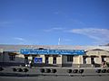
Kushok Bakula Rimpochee Airport
-
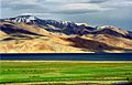
Tsomoriri lake
-
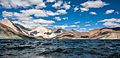
Pangong lake
-
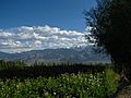
Leh district flower fields and mountains


.jpg)
See also
 In Spanish: Distrito de Leh para niños
