
Aksai Chin facts for kids
Quick facts for kids Aksai Chin |
|||||||
|---|---|---|---|---|---|---|---|

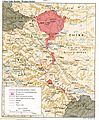
India–China border, showing Aksai Chin
|
|||||||
| Traditional Chinese | 阿克賽欽 | ||||||
| Simplified Chinese | 阿克赛钦 | ||||||
|
|||||||
Aksai Chin is a piece of land that both China and India claim as their own. This means it's a disputed border area. Most of Aksai Chin is in the Xinjiang Autonomous Region of China. A smaller part is in the Tibet Autonomous Region.
However, India says Aksai Chin is part of its Ladakh territory. In 1962, China and India had a short war over this area and another place called Arunachal Pradesh. Later, in 1993 and 1996, both countries agreed to respect the Line of Actual Control. This is a line that shows where each country's forces are.
Aksai Chin means "Chin's desert of white stones." It is a very large, high-up desert made of salt. Some parts of it are as high as 5,000 metres (about 16,400 feet). The disputed area covers about 42,685 square kilometres (16,481 square miles).
Geography and Climate
Aksai Chin is part of the Tibetan Plateau. It is sometimes called the Soda Plain. This region has almost no people living there permanently. It also gets very little rain or snow. This is because the Himalayan mountains block the rain from the Indian monsoon.
Even though Aksai Chin is mostly empty and has no natural resources, it is very important to China. It helps connect Tibet and Xinjiang, which are two large regions in China.
Who Lives There?
Most people in Aksai Chin are Chinese military officials. There are also nomadic groups, like the Bakarwal, who travel through the area regularly. They do not stay in one place.
The best-known places where people might stop are the town of Tianshuihai and the village of Tielongtan.
Related pages
Images for kids
-
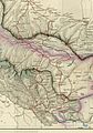
Map of Central Asia (1873) from T. Douglas Forsyth. Khotan is near top right corner. The border claimed by the British Indian Empire is shown in the two-toned purple and pink band with Shahidulla and the Kilik, Kilian and Sanju Passes north of the border.
-
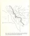
The map given by Hung Ta-chen to the British consul at Kashgar in 1893. The boundary, marked with a thin dot-dashed line, matches the Johnson line:pp. 73, 78
-
Postal map of China published by the Republic of China in 1917. The boundary in Aksai Chin is as per the Johnson line.
-
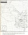
Map including the Aksai Chin region (AMS, 1950)
-
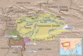
A 1988 CIA map of the western Indo-Chinese border, showing Aksai Chin and other contested territories
-
The Tarim River Basin, 2008
-
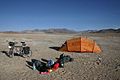
Northern plains of Aksai Chin looking towards Qitai Daban (Khitai Dawan)


See also
 In Spanish: Aksai Chin para niños
