
Sino-Indian War facts for kids
The Sino-Indian War was a short but important conflict between India and China in 1962. It happened because of disagreements over their shared border in the high Himalayas mountains. China won the war, but surprisingly, the borders didn't change much afterward.
Contents
What Caused the Sino-Indian War?
The main reason for the war was a disagreement about where the border between India and China should be. This border is very long and runs through tough mountain terrain. Both countries had different ideas about which areas belonged to them.
The Disputed Areas
There were two main areas that both countries claimed:
- Aksai Chin: This is a large, high-altitude desert area in the west. It's mostly empty, but it's important because China built a road through it. India claimed this area was part of its Jammu and Kashmir region.
- Arunachal Pradesh (then NEFA): This is a region in the east, known as the North-East Frontier Agency (NEFA) at the time. India controlled this area, but China claimed it was part of Tibet.
Historical Border Claims
The border issues went back many years, even before India became independent. When the British ruled India, they drew different maps. Some maps showed borders that included Aksai Chin as part of India. Other maps, like the McMahon Line in the east, were agreed upon by British India and Tibet, but China never fully accepted them.
Why Did Tensions Rise?
In the years leading up to 1962, both India and China built roads and military outposts in the disputed areas. This made the situation very tense. Leaders from both sides tried to talk and find a peaceful solution, but they couldn't agree.
The Dalai Lama's Escape
In 1959, the 14th Dalai Lama, the spiritual leader of Tibet, fled to India after an uprising against Chinese rule. India gave him shelter, which made China very angry. This event worsened the relationship between the two countries.
How the War Unfolded
The war officially began on October 20, 1962. It was a short but intense conflict.
China's Attack
Chinese troops launched attacks in both the western (Aksai Chin) and eastern (Arunachal Pradesh) sectors of the border. They quickly pushed back the Indian forces. The Indian army was not fully prepared for a large-scale mountain war.
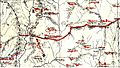
Key Battles and Locations
Some of the fighting happened in very difficult conditions, high up in the mountains.
- Western Sector: Battles took place in areas like the Galwan Valley and Rezang La. Chinese forces advanced deep into Indian-claimed territory in Aksai Chin.
- Eastern Sector: Chinese troops quickly captured towns like Tawang and Bomdila in Arunachal Pradesh. They advanced close to the plains of Assam.
India's Response
India was surprised by the speed and scale of the Chinese attack. Prime Minister Jawaharlal Nehru asked for help from other countries, including the United States and the United Kingdom.
The Ceasefire
After about a month of fighting, on November 21, 1962, China suddenly declared a ceasefire (a stop to the fighting) and withdrew its troops from most of the areas they had captured in the east. They kept control of Aksai Chin in the west.
Aftermath of the War
Even though China won the war on the battlefield, the border largely returned to how it was before the conflict, except for Aksai Chin.
Impact on India
The war was a big shock for India. It led to changes in India's defense policies and its approach to foreign relations. India started to focus more on strengthening its military.
Impact on China
China achieved its goal of securing the Aksai Chin area, which was important for its road connecting Tibet and Xinjiang. The war also showed China's military strength.
The Border Today
The border dispute between India and China is still not fully resolved. Both countries continue to have different ideas about where the Line of Actual Control (LAC) – the de facto border – should be. They have had many rounds of talks to try and settle the issue peacefully.
Images for kids
-
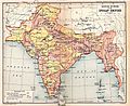
Pre-Simla British map published in 1909 shows the so-called "Outer Line" as India's northern boundary.
-
Postal Map of China published by the Government of China in 1917
-
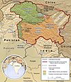
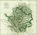
Traditional borders of Jammu and Kashmir (CIA map). The northern boundary is along the Karakash valley. Aksai Chin is the shaded region in the east.
-
1878 British map, with trade routes between Ladakh and Tarim Basin marked. The border preferred by British Indian Empire, shown in two-toned purple and pink, included the Aksai Chin and narrowed down to the Yarkand River.
-
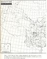
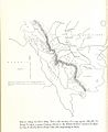
W. H. Johnson's route to Khotan and back (1865). Johnson's proposed boundary ran along the "norther branch" of the Kunlun Mountains. (Its curvature is exaggerated.)
-
The map of Hung Ta-chen handed to the British consul at Kashgar in 1893. The boundary, marked with a thin dot-dashed line, agrees with the 1878 British map.
-
The McMahon Line is the red line marking the northern boundary of the disputed area.
-
McMahon Line 1914, Map 1
-
The McMahon Line in the Tawang sector.
-
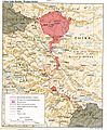
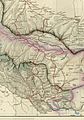
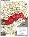
The disputed areas in the western sector, shown in a 1988 map from the CIA.
-

U.S. Ambassador to India John Kenneth Galbraith and Prime Minister Nehru conferring at the time of the conflict. This photograph was taken by the United States Information Service (USIS) and sent to President John F. Kennedy with a letter from Galbraith dated 9 November 1962.


See also
 In Spanish: Guerra sino-india para niños
