
Line of Actual Control facts for kids

The Line of Actual Control (LAC) is like an unofficial border between India and China. It's a very long line, about 4,057 kilometers (2,521 miles) long. This line goes through three main areas in northern India:
- The western part, which includes Ladakh and Kashmir.
- The middle part, covering Uttarakhand and Himachal Pradesh.
- The eastern part, which includes Sikkim and Arunachal Pradesh.
Sometimes, Chinese troops cross this line. This happens to show China's claim over certain areas. It also ensures India doesn't change its policy on Tibet.
The term "Line of Actual Control" was first used by Chinese Prime Minister Zhou Enlai. He wrote about it in a letter to Indian Prime Minister Nehru on October 24, 1959. Later, on November 7, Zhou explained that the LAC included the "McMahon Line" in the east. In the west, it was the line where each country actually had control.
During the Sino-Indian War in 1962, Prime Minister Nehru said he didn't know where this line was. He felt China's offer to move back 20 kilometers was misleading. He believed China had moved forward a lot through military action. Then, they offered to withdraw a small part. It's important to know that India had also started a "forward policy." This meant India began to challenge areas controlled by China. Some of these areas were not even part of the original McMahon Line.
Images for kids
-
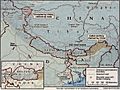
Line of Actual Control between China and India (map by the CIA)
-
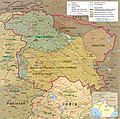
The western portion of the Line of Actual Control, separating the Eastern Ladakh and Aksai Chin. In the southern Demchok region, only two claim lines are shown (map by the CIA).
-
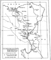
The 1956 and 1960 claim lines of China in the western sector, map by the CIA
-
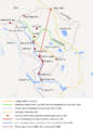
Map 2: This Indian map shows various lines, including the red line, representing India's view of the position in 1959, and the blue line, representing the position prior to the 1962 war.


See also
 In Spanish: Línea de control real para niños
