
Kargil district facts for kids
Quick facts for kids
Kargil
करगिल
|
|
|---|---|

Kargil
|
|

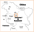
Map of Kagril district in Jammu and Kashmir
|
|
| Country | |
| State | Jammu and Kashmir |
| District | Kargil |
| Headquarters | Kargil |
| Area | |
| • Total | 14,036 km2 (5,419 sq mi) |
| Elevation | 2,676 m (8,780 ft) |
| Population
(2011)
|
|
| • Total | 140,802 |
| • Density | 10.0315/km2 (25.9814/sq mi) |
| Languages | |
| • Official | Urdu |
| • Spoken | Purik, Hindi/Urdu, Sheena, Balti |
| Time zone | UTC+5:30 (IST) |
Kargil is a district in the Ladakh region of India. It is part of the Jammu and Kashmir state. Kargil is located close to the Line of Control, which is a border area. To its north is Gilgit-Baltistan, a region administered by Pakistan. To the west are the Kashmir Valley and Jammu region.
The Kargil district is divided into 9 areas called blocks. These include Kargil, Drass, Sankoo, Taisuru, Shargole, Shakar-Chiktan, Zanskar, GM Pore/Trespone, and Lungnak. It also has three main administrative divisions called Tehsils: Kargil, Zanskar, and Sankoo. Zanskar and Drass are also sub-divisions, each managed by a Sub Divisional Magistrate.
According to a 2011 count, Kargil is the least populated district among the 22 districts in Jammu and Kashmir.
Contents
People and Population

Kargil has about 140,000 people. It is the only district in Ladakh where most people are Muslim. About 85% of the population is Muslim, and 73% of them follow Shia Islam. Most Muslims live in Kargil town, Drass, Wakha, and the lower Suru valley.
About 14% of the people in Kargil follow Tibetan Buddhism. The remaining 1% follow Hinduism and Sikhism. Many people in Kargil are from the Burig and Balti groups. These groups have Tibetan roots. They changed from Buddhism to Islam in the 16th century. Recently, some people from Kashmir and Jammu have moved to Kargil.
Geography and Climate

Kargil district is located in the Himalayas mountains. This gives it a cool, mild climate. Summers are warm during the day but cool at night. Winters are very long and cold. Temperatures can often drop to −15 °C (5 °F). In the small town of Dras, which is 56 km (35 mi) from Kargil, temperatures have been recorded as low as −60 °C (−76 °F). The Zanskar Valley is even colder.
Kargil district covers a large area of 14,086 square kilometers (5,439 sq mi). The Suru River flows through the district. National Highway 1D connects Srinagar to Leh and passes through Kargil. This highway is usually open only from May to December. This is because of heavy snowfall at a mountain pass called Zoji La.
Culture and Traditions

In the past, the people of Kargil and Leh were influenced by Tibetan culture. However, after Shia Islam spread, the culture of Kargil became very influenced by Persian traditions.
Even today, social events like weddings still have many customs and rituals. These are common for both Muslims and Buddhists in the area. Local folk songs, known as rgya-glu, and balti ghazals are still very popular. People perform them with excitement at social gatherings.
The J&K tourism ministry holds festivals every year. These events showcase the local culture to help the tourism industry grow. However, tourism is still not fully developed in Kargil. This is despite its beautiful nature and rich culture. The main reasons are poor facilities and not enough places for visitors to stay.
Images for kids
-
Map of Kargil (this map includes a territory under Chinese administration as a part of Aksai Chin)
-
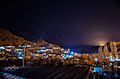
Kargil city at night
-
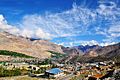
Panorama of Kargil
-
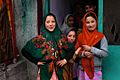
Local girls in Kargil
-
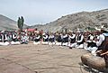
Shina cultural performance in Kargil
-
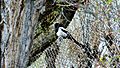
The Eurassian Magpie, a common sight in Kargil
-
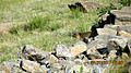
A Marmot, found in the wild in Ladakh
-

Ladakh toad head agama (Phrynocephalus theobaldi), at Kargil campus University of Ladakh
-
An adult Himalayan Agama (Paralaudakia himalayana), at Ringmospang Kargil
-
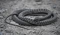
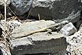
An adult Ladakh cliff racer (Platyceps ladacensis), from Gongma Minji Kargil
-
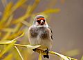
European Goldfinch (Carduelis carduelis) at Ringmospang Kargil


.jpg)
See also
 In Spanish: Distrito de Kargil para niños
