Kargil facts for kids
Quick facts for kids
Kargil
|
|
|---|---|
|
City
|
|
 |
|

|
|
| Administrating country | India |
| Region of administration | Union territory of Ladakh |
| District | Kargil |
| Tehsil | Kargil |
| Government | |
| • Type | Ladakh Autonomous Hill Development Council, Kargil |
| Area | |
| • Total | 2.14 km2 (0.83 sq mi) |
| Elevation | 2,676 m (8,780 ft) |
| Population
(2011)
|
|
| • Total | 16,338 |
| • Density | 7,635/km2 (19,770/sq mi) |
| Others | |
| Time zone | UTC+5:30 (IST) |
| PIN |
194103
|
| Vehicle registration | LA 01 |
| Official languages | Urdu, Purgi, Ladakhi, Brokskat, English |
| Other spoken | Shina, Balti |
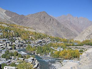
Kargil, also spelled Kargyil, is a city in Ladakh, a region managed by India in the Kashmir area. It shares the title of capital for Ladakh, which is a special administrative region in India. It is also the main office for the Kargil district. After Leh, Kargil is the second-largest city in Ladakh.
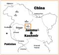
Kargil is about 204 kilometers (127 miles) east of Srinagar in Jammu and Kashmir. It is also about 234 kilometers (145 miles) west of Leh. The city sits on the banks of the Suru River. This is where it meets the Wakha Rong river, which offers an easy path to Leh.
Contents
What's in a Name? The Meaning of Kargil
The name Kargil has a few interesting meanings. Old writings from Ladakh, called the Ladakh Chronicles, spell it as dkar skyil. This can mean a "bright" or "wholesome expanse." Imagine a wide, open, and pleasant area.
Newer newspapers sometimes spell it as dkar `khyil. This could mean a "bright" or "wholesome mountainous amphitheater." This phrase is often found in Tibetan stories.
The area around Kargil does feel like a wide space surrounded by mountains. This is different from the deep, narrow valleys that lead into it.
Some local people believe the name comes from Khar (meaning fort) and rkil (meaning center). So, they think Kargil means a "central place among many forts." This makes sense because Kargil is located almost equally far from Srinagar, Leh, and Skardu.
Where is Kargil Located?
Kargil is a very important place because it sits where several river valleys meet. These include the Suru River valley, the Wakha Rong valley (which goes towards Leh), and the Sod Valley (which leads to the Indus Valley).
Also, the Dras River valley branches off nearby, leading to the Zoji La pass and the Kashmir region. Further north along the Suru valley, you can reach the Indus valley, which goes to Skardu. This means Kargil is a key meeting point for routes connecting Kashmir, Ladakh, and Baltistan.
In the past, the main trade route between Baltistan and Leh also passed through Kargil. This was because the Indus Valley was too difficult to travel through directly.
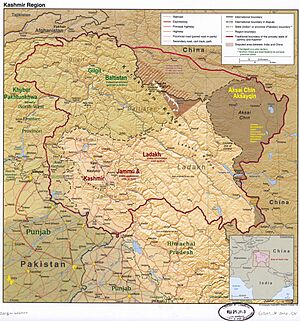
After India became independent, the Line of Control (LOC) was drawn. This line separates areas controlled by India and Pakistan. The LOC is about 11 kilometers (7 miles) north of Kargil. During the Indo-Pakistan War of 1971, Indian forces moved the LOC further north. This helped make Kargil safer.
Kargil's Past: A Look at its History
Even though Kargil is in a central spot, it wasn't a large settlement in medieval times. Instead, there were two strong forts nearby. One was called Sod Pasari (now Pasar Khar) in the Sod Valley. This fort was the capital of "Lower Purig" by the 16th or 17th century. Later, another fort was built at Pashkum.
Kargil's Growth: The Dogra Period
In 1834, during an invasion of Ladakh, the Dogras attacked and destroyed the forts at Sod Pasari and Pashkum. After this, an administrator was placed in Kargil and Drass. A new fort was built in Kargil to help control the area. This fort was about 60 yards square and could protect the bridge over the Suru River and the road connecting Kashmir and Ladakh.
Later, the people of the region rebelled, but the Dogras sent more forces. They took control again and kept the Kargil fort guarded. By 1854, Kargil became one of three sub-districts in the area, each with civil officers. This is how Kargil started to grow into an important administrative center and town.
Over time, Kargil became a tehsil (a type of administrative division) within a larger district. The headquarters for this district would move between Kargil, Skardu, and Leh each year.
Kargil as a Trade Hub
For many years, Kargil and Leh were important stops on the trade routes between South Asia and Central Asia. This was true until the mid-20th century. Because of this trade, Kargil had a serai (a rest-house for travelers), and post and telegraph offices.
The shops in Kargil's market sold many goods. These included matches, kerosene oil, different types of sugar and tea, cotton cloth from places like Bombay and Manchester, and cheap glass ornaments.
Kargil in Independent India
After India became independent in 1947, the First Kashmir War (1947–48) ended with a ceasefire line. This line divided the Ladakh region. Kargil and Leh stayed on the Indian side, while Skardu went to Pakistan. Later, Kargil and Leh became separate districts.
In 1999, Pakistani forces entered the area, leading to the Kargil War. Fighting happened along a 160-kilometer (100-mile) stretch of ridges. These ridges overlooked the main road connecting Srinagar and Leh. Military outposts on these ridges were very high up, some as high as 5,485 meters (18,000 feet). After several months of fighting, the Pakistani forces had to go back to their side of the Line of Control.
Kargil's Geography and Climate
Kargil is located at an average height of 2,676 meters (8,780 feet) above sea level. It is situated along the banks of the Suru River (Indus).
The town is about 205 kilometers (127 miles) from Srinagar. It faces Gilgit-Baltistan across the LOC. Like other areas in the Himalayas, Kargil has a moderate climate. Summers are warm with cool nights. Winters are long and very cold, with temperatures often dropping below -20 °C (-4 °F).
People of Kargil: Demographics
The population of Kargil town has grown a lot. In 1961, there were 1,681 people. By 2011, this number had increased to 16,338 people. This shows that more people are living in the town area.
According to the 2011 Census of India, Kargil town had 16,338 residents. Out of these, 10,082 were males and 6,256 were females. About 9.6% of the population were children aged 0-6 years. The literacy rate in the town is 75.53%. This means that 85.57% of males and 59.35% of females can read and write.
Religion in Kargil City
Islam is the main religion in Kargil City, followed by over 92% of the people. Buddhism is the second-largest religion, with about 7.8% of the population. A very small number of people, about 0.003%, follow Sikhism.
Media and Communication in Kargil
All India Radio has a channel called AIR Kargil AM 684. This channel is broadcast from a radio station located in Kargil. Greater Ladakh is a popular newspaper in the Union Territory. It is published once a week and is printed in two languages.
Getting Around: Transportation in Kargil
Air Travel
Kargil Airport is about 8 kilometers (5 miles) from the town. It is not currently in use for regular flights but is planned to open soon as part of the UDAN scheme. The closest airport that is currently operating is the Srinagar International Airport.
Train Travel
There are no train lines that go to Kargil yet. However, there is a plan to build a railway line that will connect Srinagar and Leh, passing through Kargil. The nearest major train station is Jammu Tawi railway station, which is 472 kilometers (293 miles) away.
Road Travel
A major Indian national highway (NH 1) connects Srinagar to Leh and goes right through Kargil. This road is very important for travel and trade in the region.
Skardu–Kargil Road
The Skardu–Kargil Road used to connect Kargil to Skardu, a city in Gilgit-Baltistan. This road was open all year round. However, it has been closed since the 1948 Kashmir War. The Indian Government has suggested opening the road again to help people, but the Pakistani government has not agreed to this.
Images for kids
See also
 In Spanish: Kargil para niños
 | DeHart Hubbard |
 | Wilma Rudolph |
 | Jesse Owens |
 | Jackie Joyner-Kersee |
 | Major Taylor |


