Ghanche District facts for kids
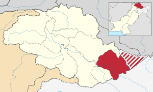
Ghanche District is a cool place in Gilgit-Baltistan, Pakistan. It's known for being super cold! It's also home to amazing mountains. This district is in the eastern part of Gilgit-Baltistan.
Location and Neighbors
Ghanche District is in the eastern part of Gilgit-Baltistan. To its northeast is Xinjiang, China. To the north and northwest is Skardu District. Astore District is to its west. To its south is Leh District in India. There's a special line called the Line of Control. It goes through the Siachen Glacier. This area has seen some conflict. People have suggested making the Siachen Glacier a "Peace Park." This would be a place where countries work together.
Capital and Climate
The main town in Ghanche District is Khaplu. This place is one of the coldest spots in Pakistan. Some even call it the "Third Pole"! In winter, temperatures can drop below -20 degrees Celsius (-4 degrees Fahrenheit). Brrr!
Mountains and Adventure
Khaplu and Hushe valleys are like a doorway to huge mountains. These include the famous K2, which is 8,611 meters (28,251 feet) tall. K2 is the second-highest mountain in the world! Other tall peaks nearby are Broad Peak (8,047 meters), Gasherbrums (over 8,000 meters), and Masherbrum (7,821 meters). These giant mountains are part of the Karakoram mountain range.
Tehsils
Ghanche District is divided into smaller areas called Tehsils. These are:
- Khaplu Tehsil
- Mashabrum Tehsil
Images for kids
-
The 7,821 meter (25,659 feet) tall Masherbrum peak as viewed from Surmo.
-
The village of Ghursay, in a picture taken from the Saling Bridge over the Shyok River.
-
The historic village of Machlu, which features a mosque built in the typical style of the Baltistan Division.
-
The Chaqchan Mosque, which dates to 1370 A.D., around the time that the district's inhabitants converted to Islam.
 | Isaac Myers |
 | D. Hamilton Jackson |
 | A. Philip Randolph |


