
Kashmir conflict facts for kids
Quick facts for kids Kashmir Conflict |
|||||||
|---|---|---|---|---|---|---|---|
|
India claims the entire erstwhile princely state of Jammu and Kashmir based on an instrument of accession signed in 1947. Pakistan claims Jammu and Kashmir based on its majority Muslim population, whereas China claims the Shaksam Valley and Aksai Chin. |
|||||||
|
|||||||

The Kashmir conflict is a disagreement about who owns the land called Kashmir. It's mainly a dispute between India and Pakistan. India believes it owns all of the region that was once a "princely state" (a state ruled by a local prince under British rule). India currently controls about 43% of this land. This includes most of Jammu, the Kashmir Valley, Ladakh, and the Siachen Glacier.
Pakistan disagrees with India's claim. Pakistan controls about 37% of Kashmir. This includes areas like Azad Kashmir and the northern parts of Gilgit and Baltistan. Pakistan believes the people of Kashmir should vote to decide if they want to join India, Pakistan, or become an independent country.
Contents
History of the Kashmir Conflict
This conflict began when India was divided into two separate countries, India and Pakistan, in 1947. On October 20, 1947, tribesmen supported by Pakistan entered Kashmir. The ruler of Kashmir, called the Maharaja, first fought back. But then he asked India for help.
India's leader, Louis Mountbatten, agreed to help. But only if the Maharaja officially joined Kashmir with India. After the papers were signed, Indian soldiers went into Kashmir. They were told to stop more fighting but not to push anyone out. India then took the problem to the United Nations.
UN Involvement and Ceasefire
The United Nations passed a resolution. It asked Pakistan to leave the areas it had taken. It also asked India to help the UN set up a vote for the people of Kashmir. This vote would decide what the people wanted. However, Pakistan refused to leave the areas it controlled.
In 1947-1948, India and Pakistan fought their first war over Kashmir. Under the UN's watch, they agreed to stop fighting. They drew a line called the "ceasefire line." This line left one-third of Kashmir under Pakistan's control. The other two-thirds, including Jammu, Ladakh, and the Kashmir Valley, stayed with India. In 1972, this ceasefire line was renamed the Line of Control.
The Line of Control
India says that all of Kashmir belongs to it. But India has been willing to accept the Line of Control as the official border. The United States and the United Kingdom also support making this line a permanent international border.
However, Pakistan has always refused to accept the Line of Control as the border. This is because the Kashmir Valley has mostly Muslim people. If the line became the border, the valley would remain part of India. Also, many Kashmiris have been fighting for independence since 1989. They want the whole or part of Kashmir to be its own country.
Water and the Kashmir Dispute
Another reason for the conflict over Kashmir is water. Many important rivers start in Kashmir. Some of these rivers flow into Pakistan. They are used there for watering crops. These include the Jhelum and Chenab River, which are part of the Indus River system. Other rivers, like the Ravi and Sutlej, flow into northern India.
When India and Pakistan were separated in 1947, many of Pakistan's irrigation systems ended up being controlled from India. Pakistan worried that India could stop the flow of rivers. This would hurt Pakistan's farming economy. To solve this, the Indus Waters Treaty was signed in 1960. This treaty helped settle most of the water sharing problems.
Kashmir's Current Status
Today, Kashmir is divided into different parts:
- India controls the state of Jammu and Kashmir. This includes the Jammu region, the Kashmir valley, and Ladakh. Pakistan often calls this "Indian occupied Kashmir."
- The areas known as Northern Areas and Azad Kashmir are managed by Pakistan. Pakistan calls these "Pakistan-administered Kashmir." India refers to this as "Pakistan-occupied Kashmir."
- The region called Aksai Chin is controlled by China. China also controls a small area it received from Pakistan, called the Trans-Karakoram Tract. India disputes whether Pakistan had the right to give this land to China.
- The Siachen Glacier is a disputed area. India controls the glacier itself, while Pakistan controls the valley below it.
- The Trans-Karakoram Tract was given by Pakistan to China in 1963. Pakistan says this area was empty, so there was no problem. India claims this area as part of its state of Jammu and Kashmir.
Kashmir has been a major point of tension between India and Pakistan for over 60 years. The Line of Control divides the region. One part is controlled by India's military, and the other is managed by Pakistan. India wants to make this line the official international border. But Pakistan and Kashmiri activists do not agree. They both want more control over the region.
Maps and Disputed Borders
When governments make maps, they show their claims in Kashmir as part of their own country. This is true even if they don't actually control the land. In India, it's against the law to make a map that doesn't show all of Kashmir as part of India. In Pakistan, it's illegal not to show Kashmir as a disputed territory, as allowed by the United Nations.
Countries that are not involved in the dispute often use the Line of Control as the border on their maps. For example, the CIA World Factbook does this. These maps often mark the region with hash marks. However, the Indian government strongly opposes this. When Microsoft released a map in Windows 95, it caused a problem because it didn't show all of Kashmir as part of India. Most neutral and Pakistani companies follow the United Nations' map, which shows Kashmir as disputed territory.
Images for kids
-
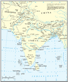
Map of the UN's version of the South Asia region
-
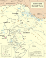
Map of the UN's version of the Kashmir region
-
Map of the UN's version of the Republic of India and disputed areas
-
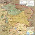
India claims the entire erstwhile British Indian princely state of Jammu and Kashmir based on an instrument of accession signed in 1947. Pakistan claims most of the region based on its Muslim-majority population, whereas China claims the largely uninhabited regions of Aksai Chin and the Shaksgam Valley.
-
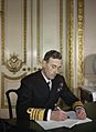
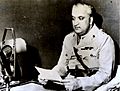
The Instrument of Accession of Kashmir to India was accepted by the Governor General of India, Lord Mountbatten.
-
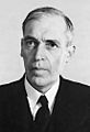
Sir Owen Dixon, UN mediator
-
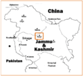
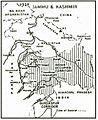
Location of conflict.
-
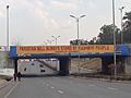
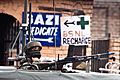
Kashmir Solidarity Day on every 5 February is observed in Pakistan. This banner was hung in Islamabad.
-
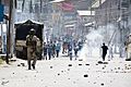
Indian police in Kashmir valley confronting violent protesters in December 2018
-
Maharaja Hari Singh signed the Instrument of Accession in October 1947 under which he acceded the State of Jammu and Kashmir to the Union of India.
-
Map of Kashmir as drawn by the Government of Pakistan
-
A soldier guards the roadside checkpoint outside Srinagar International Airport in January 2009.


_-_IND_-_UNOCHA.svg)


.jpg)


See also
 In Spanish: Conflicto de Cachemira para niños
