
Siachen Glacier facts for kids
Quick facts for kids Siachen Glacier |
|
|---|---|
 |
|
| Type | Mountain glacier |
| Location | Karakoram Range, Ladakh Controlled by India, disputed by Pakistan |
| Coordinates | 35°24′N 77°06′E / 35.4°N 77.1°E |
| Length | 76 km (47 mi) using the longest route as is done when determining river lengths or 70 km (43 mi) if measuring from Indira Col |
_(claims_hatched).svg)
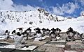
The Siachen Glacier is a massive river of ice located in the eastern Karakoram mountain range. It is part of the huge Himalaya Mountains. This glacier sits along the border between India and Pakistan, in an area that both countries claim.
Before it became a place of conflict, people called Siachen the "Land of Wild Roses." It is the longest glacier in the Karakoram range. It is also the second longest glacier in the world outside of the North and South Poles! The glacier starts very high up, at about 5,753 meters (18,875 feet) above sea level. This starting point is at a pass called Indira Col, near the border with China. The glacier then flows down to about 3,620 meters (11,875 feet).
The Siachen Conflict
The conflict in the Siachen area began on April 13, 1984. This area is in the northern part of Kashmir. Kashmir is a region that both India and Pakistan have fought over. It was the reason for two of their three major wars.
Since 1984, soldiers from India and Pakistan have faced each other in the mountains above the Siachen Glacier. There are between 10,000 and 20,000 troops combined in this very difficult area. The land around Siachen is often called a "no-man's-land." It is about 6,000 meters (20,000 feet) above sea level.
Military experts say that the harsh weather and dangerous avalanches have caused more deaths than actual fighting. The importance of the glacier for military reasons is still debated. Before 1984, neither country had troops stationed there.
Both India and Pakistan agree that they need to remove their soldiers from the glacier. However, neither side wants to be the first to move. India controls the high ground and does not want to leave. They worry Pakistan might move in if they withdraw. India says it will not bring its forces down until Pakistan officially confirms the positions they hold. Pakistan has said it is willing to do this. But they want to make sure it does not mean they agree with India's claim over the glacier. The glacier is also a source of meltwater for Pakistan's rivers.
Images for kids
-
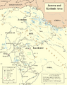
UN map of the Line of Control in Kashmir, which ends at the point NJ980420
-
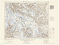
Historical map including Siachen Glacier (AMS, 1953)
-
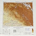
Historical map including Siachen Glacier (AMS, 1966)
-
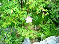
A Sia plant in Khaplu. Local people grow this rose family plant as decoration. Its bark is used in payo cha (butter tea) instead of green tea leaves in some areas.
-
Indian Army soldiers performing Yoga on the 3rd International Day of Yoga in Siachen on June 21, 2017.


.jpg)
See also
 In Spanish: Glaciar de Siachen para niños
