Besham facts for kids
Quick facts for kids
Besham
|
|
|---|---|
|
City
|
|

Besham, Pakistan
|
|
| Country | |
| Province | |
| District | Shangla |
| Elevation | 613 m (2,011 ft) |
| Time zone | UTC+5 (PST) |
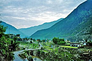
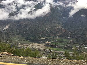
Besham is a city in Pakistan. It is located in the Shangla District of Khyber Pakhtunkhwa province. People also call it Besham Qila.
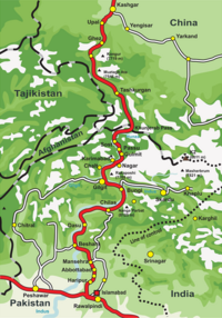
The city sits on the right bank of the Indus River. Locals call the river Abasin. Besham is a very important stop on the Karakoram Highway. This highway connects Khyber Pakhtunkhwa and Punjab with Gilgit-Baltistan. It also goes all the way to China's Xinjiang region.
Besham is also the start of a new highway called the E90 expressway. This road will connect Besham to Khwazakhela in Swat District. Besham is about 60 kilometers (37 miles) east of Swat. It is also about 250 kilometers (155 miles) north of Rawalpindi-Islamabad. The provincial capital, Peshawar, is about 270 kilometers (168 miles) northeast.
Long ago, this area was home to many Buddhist holy people. There are also old historical sites here. Besham used to be part of the State of Swat. Later, it was part of Swat District. Then, on July 10, 1995, the Shangla District was created, and Besham became part of it.
Visiting Besham: A Tourist Stop
Many tourists pass through Besham. They use the Karakoram Highway to reach places like Hunza and Gilgit. This is often the best route. The other way, through the Kaghan Valley, can be blocked by heavy snow.
The Pakistan Tourism Development Corporation has a rest house in Besham. It is right on the bank of the Indus River. This makes it a good place for travelers to stop and relax.
Besham's Weather: What to Expect
Besham has a mild and generally warm climate. This type of weather is called a humid subtropical climate. Even in the driest months, Besham gets a good amount of rain.
The average temperature in Besham is about 20.7 °C (69.3 °F). The city gets about 842 mm (33 inches) of rain each year. November is the driest month, with only about 18 mm (0.7 inches) of rain. August is the wettest month, with about 138 mm (5.4 inches) of rain.
June is the hottest month of the year. The average temperature then is about 30.6 °C (87.1 °F). January is the coldest month. The average temperature in January is about 8.9 °C (48.0 °F).
| Climate data for Besham | |||||||||||||
|---|---|---|---|---|---|---|---|---|---|---|---|---|---|
| Month | Jan | Feb | Mar | Apr | May | Jun | Jul | Aug | Sep | Oct | Nov | Dec | Year |
| Mean daily maximum °C (°F) | 14.9 (58.8) |
17.5 (63.5) |
22.5 (72.5) |
27.6 (81.7) |
33.3 (91.9) |
38.4 (101.1) |
36.9 (98.4) |
35.2 (95.4) |
33.8 (92.8) |
29.6 (85.3) |
23.6 (74.5) |
17.2 (63.0) |
27.5 (81.6) |
| Daily mean °C (°F) | 8.9 (48.0) |
11.5 (52.7) |
16.0 (60.8) |
20.8 (69.4) |
25.9 (78.6) |
30.6 (87.1) |
30.4 (86.7) |
29.1 (84.4) |
26.8 (80.2) |
21.6 (70.9) |
15.8 (60.4) |
10.7 (51.3) |
20.7 (69.2) |
| Mean daily minimum °C (°F) | 3.0 (37.4) |
5.6 (42.1) |
9.6 (49.3) |
14.1 (57.4) |
18.5 (65.3) |
22.9 (73.2) |
23.9 (75.0) |
23.1 (73.6) |
19.9 (67.8) |
13.7 (56.7) |
8.1 (46.6) |
4.2 (39.6) |
13.9 (57.0) |
| Source: Climate-Data.org | |||||||||||||
 | Dorothy Vaughan |
 | Charles Henry Turner |
 | Hildrus Poindexter |
 | Henry Cecil McBay |


