
Nepal facts for kids
Quick facts for kids
Federal Democratic Republic of Nepal
|
|
|---|---|
 Emblem
|
|
|
Motto: जननी जन्मभूमिश्च स्वर्गादपि गरीयसी (Sanskrit)
Janani Janmabhumishcha Swargadapi Gariyasi "Mother and Motherland are Greater Than Heaven" |
|
.svg) Location of Nepal Territory claimed but not controlledNepal on the globe Location of Nepal Territory claimed but not controlledNepal on the globe.jpg) Administrative map of Nepal Administrative map of Nepal |
|
| Capital and largest city
|
Kathmandu 28°10′N 84°15′E / 28.167°N 84.250°E |
| Official languages | Nepali |
| Recognised national languages | All mother-tongues (see Languages of Nepal) |
| Ethnic groups
(2021)
|
|
| Religion
(2021)
|
|
| Demonym(s) | |
| Government | Federal parliamentary republic under an interim government |
| Ram Chandra Poudel | |
| Ram Sahaya Yadav | |
| Balendra Shah | |
| Legislature | Federal Parliament |
| National Assembly | |
| House of Representatives | |
| Formation | |
|
• Unification
|
25 September 1768 |
| 4 March 1816 | |
| 21 December 1923 | |
|
• Federal Republic
|
28 May 2008 |
|
• Current constitution
|
20 September 2015 |
| Area | |
|
• Total
|
147,516 km2 (56,956 sq mi) (93rd) |
|
• Water (%)
|
2.8% |
| Population | |
|
• 2024 estimate
|
|
|
• Density
|
180/km2 (466.2/sq mi) (72nd) |
| GDP (PPP) | 2024 estimate |
|
• Total
|
|
|
• Per capita
|
|
| GDP (nominal) | 2024 estimate |
|
• Total
|
|
|
• Per capita
|
|
| Gini (2022) | 30.0 medium |
| HDI (2023) | medium · 145th |
| Currency | Nepalese rupee (Rs, रू) (NPR) |
| Time zone | UTC+05:45 (Nepal Standard Time) |
| Date format | YYYY/MM/DD |
| Driving side | left |
| Calling code | +977 |
| ISO 3166 code | NP |
| Internet TLD | .np |


Nepal (Nepali: नेपाल) is a country in South Asia. It shares borders with India and China. Nepal is famous for being home to Mount Everest, the world's highest mountain. It also has 12 of the 18 highest mountain peaks on Earth.
Nepal is also known as the birthplace of Buddha. It is a very important place for both Hindus and Buddhists to visit. In 2007, about 29 million people lived in Nepal.
The official language is Nepali. Many other local languages are spoken too. People often understand English and Hindi. The capital city is Kathmandu, which has over two million people. Pokhara is the second largest city and a popular spot for tourists. It is known for its beautiful nature and many lakes, like Phewa Tal.
Nepal's Past: A Journey Through Time

The history of Nepal is closely connected to the history of the wider Indian subcontinent and nearby areas. Nepal is a country with many different ethnic groups, cultures, religions, and languages. Nepali is the most spoken language.
In the 20th and early 21st centuries, Nepal worked hard to become a democracy. From the 1990s until 2008, the country faced a civil conflict. A peace agreement was signed in 2006. In the same year, the Nepalese parliament voted to end the monarchy. Nepal officially became the 'Federal Democratic Republic of Nepal' in 2008. This ended the 200-year rule of the Shah dynasty.
Exploring Nepal's Geography


Nepal is shaped like a trapezoid. It is about 800 kilometers (500 miles) long and 200 kilometers (120 miles) wide. Its total area is about 147,181 square kilometers (56,956 square miles).
Nepal is divided into three main natural areas:
- Himal: This is the high mountain region in the north. It has snow all year round.
- Pahad: This is the middle mountain region. It usually does not have snow.
- Terai: These are the southern lowland plains bordering India.
These areas run from east to west. Major rivers flow from north to south through them.
The Terai Plains
The southern plains, called Terai, are part of the Indo-Gangetic Plain. This lowland area has some small hills. Three major Himalayan rivers, the Kosi, the Narayani, and the Karnali, feed these plains. The climate here is subtropical to tropical. The Sivalik Hills mark the edge of these plains.
The Pahad Mountains
Pahad is a mountain region where snow does not usually fall. The mountains range from 800 to 4,000 meters (2,600 to 13,000 feet) high. The climate changes from subtropical at lower levels to alpine at higher levels. Many people live in the valleys here. Fewer people live above 2,000 meters (6,600 feet).
The Himal Mountains
Himal is the snowy mountain region in northern Nepal. It is part of the Great Himalayan Range. This area has the world's highest peaks. Mount Everest, at 8,848 meters (29,029 feet), is on the border with China. Seven other "eight-thousanders" (mountains over 8,000 meters or 26,000 feet) are also in Nepal or on its border. These include Lhotse, Makalu, Cho Oyu, Kangchenjunga, Dhaulagiri, Annapurna, and Manaslu.
Nepal's Climate Zones
Nepal has five different climate zones based on altitude:
- Tropical and Subtropical zones: Below 1,200 meters (3,900 feet).
- Temperate zone: 1,200 to 2,400 meters (3,900 to 7,900 feet).
- Cold zone: 2,400 to 3,600 meters (7,900 to 11,800 feet).
- Subarctic zone: 3,600 to 4,400 meters (11,800 to 14,400 feet).
- Arctic zone: Above 4,400 meters (14,400 feet).
Nepal has five seasons: summer, monsoon, autumn, winter, and spring. The Himalaya mountains block cold winds from Central Asia in winter. They also help create the monsoon wind patterns. Nepal is a popular place for mountaineering because of its high and challenging mountains. Many climbers prefer to trek to Everest from the Nepali side.
Amazing Biodiversity
_data.jpg)
Nepal has a huge variety of plants and animals for its size. It is part of the eastern Himalayan biodiversity hotspot. The big differences in height, from 60 meters (200 feet) above sea level to 8,848 meters (29,029 feet) at Mount Everest, create many different biomes. Eastern Nepal has more biodiversity because it gets more rain.
Nepal is home to:
- 4.0% of all mammal species.
- 8.9% of bird species.
- 1.0% of reptile species.
- 2.5% of amphibian species.
- 1.9% of fish species.
- 3.7% of butterfly species.
- 0.5% of moth species.
- 0.4% of spider species.
It also has 2% of flowering plant species, 3% of pteridophytes, and 6% of bryophytes.
_4.jpg)
About 40.36% of Nepal's land is covered by forests. Another 4.38% is scrubland. This means over 44% of the country is forested. In the southern plains, the Terai–Duar savanna and grasslands have very tall grasses and Sal forests. The lower hills have subtropical and temperate forests with Sal, Chilaune, and Katus trees. Higher up, you find oak and rhododendron forests. Even higher, there are Subalpine coniferous forests with fir, pine, and hemlock. Above 3,500 meters (11,500 feet), you'll find alpine shrubs and meadows.
Important trees include the Azadirachta indica (neem), used in traditional medicine. The Ficus religiosa (peepal) is also special. It is said that Gautama Buddha found enlightenment under a peepal tree.

Many animal species in Nepal are unique to the region. One mammal, two bird species, two reptile species, nine amphibian species, eight fish species, and 29 butterfly species are found only in Nepal.
Nepal has 107 IUCN-listed threatened species. These include the Bengal tiger, red panda, Asiatic elephant, Himalayan musk deer, and wild water buffalo. The critically endangered gharial, Bengal florican, and white-rumped vulture are also found here. To protect its wildlife, Nepal has created many national parks and protected areas. These efforts have helped increase the numbers of endangered animals like tigers, elephants, and rhinos. Nepal has ten national parks and many other protected areas.
How Nepal is Governed
Nepal is a federal parliamentary republic with a system of many political parties. It has been called the 'Federal Democratic Republic of Nepal' since 2015.
The Government of Nepal has three main parts:
- Executive: This branch is led by the Prime Minister. The Prime Minister is chosen from the political party that wins the most seats in the House of Representatives. The Prime Minister then forms a group of ministers who run the government.
- Legislature: This is Nepal's Federal Parliament. It has two parts: the House of Representatives and the National Assembly. The House of Representatives has 275 members who serve for five years. The National Assembly has 59 members and is a permanent body.
- Judiciary: Nepal has an independent court system with three levels. The highest court is the Supreme Court, led by the Chief Justice. Below it are seven High Courts, one in each province. There are also 77 district courts. Local councils can also help solve smaller disputes.
How Nepal is Divided
Nepal is a federal republic with 7 provinces. Each province has between 8 and 14 districts. These districts are made up of local units, which are either urban (cities) or rural (villages).
There are 753 local units in total. This includes 6 big cities (metropolitan municipalities), 11 smaller cities (sub-metropolitan municipalities), and 276 other municipalities. There are also 460 rural municipalities. Each local unit is divided into smaller areas called wards. There are 6,743 wards in total.
Local governments have powers to make and enforce laws in their areas. They also have some judicial powers. Provinces have their own parliamentary systems. Local and provincial governments share some powers with the federal government.
Major Cities in Nepal

Nepal is a developing country, and its cities are growing. More than 20% of people live in urban areas. Kathmandu is the largest city and the capital of Nepal. It is often called the City of Temples because it has many Hindu and Buddhist temples. It also has five UNESCO World Heritage Sites. Kathmandu is one of the oldest cities in South Asia. It has many historic places, like Singha Durbar.
Other large cities in Nepal include Pokhara, Biratnagar, Lalitpur, Bharatpur, Birgunj, Dharan, Hetauda, and Nepalgunj.
People of Nepal

The people of Nepal are called Nepali or Nepalese. They come from three main groups who migrated from India, Tibet, and North Burma/Chinese province of Yunnan.
In 2011, Nepal's population was 26.5 million. This was almost three times more than in 1950. The average family size became smaller, from 5.44 people in 2001 to 4.9 in 2011. Many Nepali men work overseas, mostly in South Asia and the Middle East.
Nepal is a multicultural and multiethnic country. This is because it was formed by joining several small kingdoms in the 18th century. These included Mustang, Videha (Mithila), Madhesh, and Limbuwan. The oldest settlements in Mithila and Tharuhat were by the Maithil people. Northern Nepal is historically home to Kirat people, like the Rai and Limbu. In the mountainous regions, Sherpa and Lama people live in high valleys. The Nepali-speaking Khas people mostly live in central and southern areas. The Kathmandu Valley is small but has a very high population density.
The earliest inhabitants included the Kirat from the east, Newars from the Kathmandu Valley, and Tharus from Tharuhat.
Nepal's Economy

.jpg)
Before 1950, Nepal was mainly an agricultural country. Since 1951, it has started to modernize. Agriculture is still a very important part of the economy. It employs 80% of the people and makes up 37% of the country's total income (GDP). Only about 20% of Nepal's land can be farmed. Another 33% is covered by forests. The rest is mostly mountains.
Rice and wheat are the main food crops. The lowland Terai region produces more food than it needs. This extra food helps feed the hill areas that do not produce enough. The amount of monsoon rain each year greatly affects how much the economy grows.
Getting Around Nepal

Nepal is quite isolated from major global transport routes. However, air travel within the country is better. Nepal has 47 airports, with 11 having paved runways. Flights are common and carry many passengers.
Building roads and other infrastructure in the hilly and mountainous parts of Nepal is difficult and costly. In 2007, there were about 10,142 kilometers (6,302 miles) of paved roads and 7,140 kilometers (4,437 miles) of unpaved roads. There is also one 59-kilometer (37-mile) railway line in the south.
More than one-third of Nepal's people live at least a two-hour walk from the nearest all-season road. Most rural roads cannot be used during the rainy season. The main seaport for goods coming to Kathmandu is Kolkata in India. The poor road system makes it hard for people to reach markets, schools, and health clinics.
Learning in Nepal

Modern education in Nepal started in 1853 with the first school. This school was only for the families of rulers. Schooling for everyone else began after 1951. This was when a movement ended the old ruling system and brought in democracy.
Over the past 50 years, education has grown a lot in Nepal. In 2001, about 48.2% of adults (age 15+) could read and write. This was a big jump from about 5% in 1952–54.
In 1951, there were about 300 schools and two colleges with 10,000 students. Now, there are 26,000 schools, 415 colleges, five universities, and two academies for higher studies. About 5.5 million students are enrolled in these schools and colleges. They are taught by over 150,000 teachers.
Nepal's Rich Culture

Folklore is a big part of Nepali society. Traditional stories are about everyday life, love, battles, and even demons and ghosts. They show the local ways of life, culture, and beliefs. Many Nepali folktales are told through dance and music.
In rural lowlands, most houses are made of a strong bamboo frame with walls of mud and cow-dung mix. These homes stay cool in summer and warm in winter. Houses in the hills are often made of unbaked bricks with straw or tile roofs. In high mountains, houses are built with stone and have slate roofs.
National Symbols
| Emblem | Emblem of Nepal |
|---|---|
| Anthem | Sayaun Thunga Phulka |
| Language | All mother-tongues of Nepal |
| Currency | Nepalese rupee (रू) (NPR) |
| Mammal | Cow |
| Bird | Himalayan monal |
| Flower | Rhododendron arboreum |
| Sport | Volleyball |
| Colour | Crimson |
Nepal's flag is the only national flag in the world that is not rectangular. The constitution of Nepal explains how to draw it. The red color in the flag means victory or courage. It is also the color of the rhododendron, Nepal's national flower. The blue border of the flag stands for peace. The curved moon on the flag shows the peaceful nature of Nepali people. The sun represents the bravery of Nepali warriors.
The emblem of Nepal shows the snowy Himalayas, green hills, and fertile Terai plains. It is surrounded by a wreath of rhododendrons. The national flag is at the top, and a white map of Nepal is below it. A man's and woman's hands are joined to show gender equality. At the bottom is the national motto in Sanskrit: "Mother and motherland are greater than heaven."
The president is a symbol of national unity. Martyrs (people who died for their country) are symbols of patriotism. War heroes like Amar Singh Thapa, Bhakti Thapa, and Balbhadra Kunwar are highly respected. Sixteen people from Nepal's history have been named "National heroes" for their great contributions. Prithvi Narayan Shah, who founded modern Nepal, is seen as the "Father of the Nation" by many.
Holidays and Festivals

Nepal has many public holidays, about 36 days a year. The Nepali year starts in mid-April, according to the Vikram Samvat calendar. Saturday is the official weekly holiday.
Main annual holidays include Martyr's Day (February 18). There are also many Hindu and Buddhist festivals. These include Dashain in autumn, Tihar in mid-autumn, and Chhath in late autumn. During Swanti, the Newar people celebrate their New Year's Day with the Mha Puja ceremony. Nepal is a secular country, so it also has holidays for the main festivals of minority religions.
Delicious Nepali Food

Nepali food includes many different regional and traditional dishes. These foods vary a lot because of different soil types, climates, cultures, and ethnic groups. They use local spices, herbs, vegetables, and fruits. Foods like potatoes, tomatoes, maize, and chili peppers came to South Asia through the Columbian exchange and became common.
A typical Nepali meal is a simple cooked grain with tasty side dishes. These sides often include lentils, pulses, and vegetables. They are spiced with ginger, garlic, coriander, cumin, turmeric, and other spices. The meal is usually served on a platter called a thali. The main grain is in the center, with small bowls of other dishes around it.
Dal-bhat, which is steamed rice with lentil soup, is the most common meal. It can also include dairy products and sometimes meat. Flatbreads made from wheat flour, called chapati, sometimes replace rice, especially in the Terai. Dhindo, a thick porridge made from corn, millet, or buckwheat flour, is a common substitute in the hills and mountains. Tsampa, flour from roasted barley, is the main food in the high Himalayas. Throughout Nepal, sun-dried leafy greens called Gundruk are a special dish and a good substitute for fresh vegetables in winter.

Nepali cuisine also has many unique vegetarian dishes. These dishes are part of the cultural history of different groups. Ancient religions like Upanishadic Hinduism, Buddhism, and Jainism taught ahimsa (avoiding harm to all life). This led to many people in Nepal being vegetarian.

Nepali foods are different from those of its northern and southern neighbors. Nepali curries are usually lighter and tomato-based, unlike the cream-based Indian curries. Nepali momo dumplings are also more spiced than those from the north.
Newar cuisine, from the fertile Kathmandu Valley, is very rich and varied. A typical Newar meal can have more than a dozen dishes. These include grains, meat, vegetable curries, chutneys, and pickles. Some well-known Newar dishes are Kwanti (sprouted beans soup), chhwela (ground beef), chatamari (rice flour crepe), and samaybaji (centered around flattened rice). Juju dhau, a sweet yogurt from Bhaktapur, is also famous.
Thakali cuisine blends Tibetan and Indian flavors. In the Terai, Bagiya is a sweet rice flour dumpling popular with the Tharu and Maithil people. Many communities in the Terai make sidhara (sun-dried fish with taro leaves) and biriya (lentil paste with taro leaves) for the monsoon floods. Selroti, kasaar, fini, and chaku are popular sweet treats. Rice pulau or sweet rice porridge called kheer are often served at feasts. Tea and buttermilk are common non-alcoholic drinks.
Related pages
Images for kids
-

"Nēpāla" in the late Brahmi script, in the Allahabad Pillar inscription of Samudragupta (350-375 CE).
-
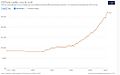
Real GPD per capita development of Nepal
-
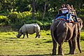
Tourists view a greater one-horned rhinoceros from an elephant in Chitwan National Park.
-
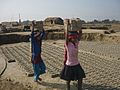
Children working in brick kilns in Nepal.
-
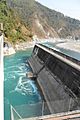
Middle Marsyangdi Hydroelectric Dam. Nepal has great potential to generate hydropower.
-

A Magar couple in their ethnic dress
-
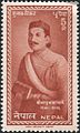
Bhanubhakta Acharya, Nepali writer who translated the ancient Hindu epic Ramayana into the Nepali language
-
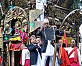
A Nepali man in traditional dress displays the bhoto during the Bhoto Jatra festival.
-
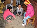
Nepali children playing a game with pebbles.
-

Nepali cricket fans are known for their enthusiastic support.

_(26428623908).jpg)


_author.jpg)


See also
 In Spanish: Nepal para niños
