Geography of Nepal facts for kids
Quick facts for kids Geography of Nepal (नेपाल) |
|
|---|---|
 |
|
| Continent | Asia |
| Region | Southern Asia coordinates = 28°00′N 84°00′E / 28.000°N 84.000°E |
| Area | Ranked 93rd |
| • Total | 147,516 km2 (56,956 sq mi) |
| • Land | 92.94% |
| • Water | 7.06% |
| Coastline | 0 km (0 mi) |
| Borders | Total land borders: 2,926 km (1,818 mi) China (PRC): 1,236 km (768 mi) India: 1,690 km (1,050 mi) |
| Highest point | Mount Everest 8,848 m (29,029 ft) |
| Lowest point | Mukhiyapatti Musharniya 59 m (194 ft) |
| Longest river | Karnali |
| Largest lake | Rara Lake |
Nepal is a fascinating country in Asia, known for its incredible mountains and diverse landscapes. It stretches about 880 kilometers (547 mi) along the Himalayas and is 150 to 250 kilometers (93 to 155 mi) wide. Its total area is about 147,516 km2 (56,956 sq mi).
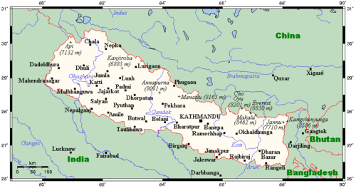
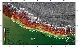
It is a landlocked country, meaning it has no coastline. To the north is China's Tibet Autonomous Region, and India surrounds it on the other three sides. Nearby countries include Bhutan and Bangladesh.
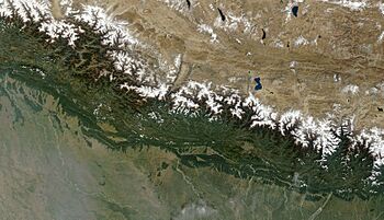
Nepal's geography is incredibly diverse. It's divided into three main areas: the Terai, the Hilly, and the Himal. The Terai is a lowland area with some hills, making up about 17% of the country. The Hilly region covers 68% and has mountains without permanent snow. The Himal region, about 15% of Nepal, is home to snowy peaks, including Mount Everest, the tallest mountain on Earth.
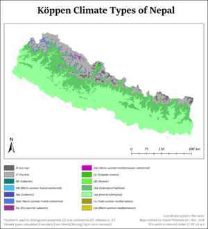
Because of its varied elevation, from less than 100 meters to over 8,000 meters, Nepal has eight different climate zones. These range from warm tropical areas to regions of permanent snow. Most people live in the tropical and subtropical zones, where many fruits and crops like rice and maize can grow. Higher up, in temperate and alpine zones, fewer people live, and farming is more challenging.
Nepal has two main seasons: a wet season from June to September and a dry season from October to June. The summer monsoon brings heavy rains, which can sometimes cause floods and landslides. The dry season is cooler and clearer. This mix of climates creates many different natural environments, from tropical grasslands to mountain forests.
Nepal's rivers are very important. The biggest ones, like the Koshi and Gandaki, start high in the Himalayas. These rivers can sometimes flood, making travel difficult. Managing these rivers means finding ways to prevent floods and provide water for farming and electricity. Building dams can be tricky because of earthquakes and how much sediment the rivers carry.
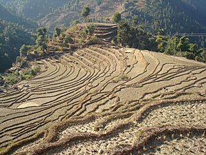
Forests cover about 39% of Nepal, and farmlands make up nearly 30%. The hilly areas have a lot of cultivated land and natural plants. Sadly, Nepal's forests are shrinking because people cut down trees for firewood, illegal logging, and to make space for farms and buildings. Protecting these forests is very important for the environment. Nepal faces challenges with air pollution, especially in its cities.
Contents
Nepal's Diverse Landscapes
Nepal has amazing geographic variety for its size. Its land goes from low tropical plains, just 59 metres (194 ft) above sea level, all the way up to snowy peaks over 7,000 metres (22,966 ft) high. This includes Mount Everest, which stands at 8,848 metres (29,029 ft)! The weather also changes a lot, from warm tropical areas to cold, polar-like regions. Rainfall varies greatly, depending on how much the summer monsoon brings.
From south to north, Nepal is divided into three main zones: the Terai, the Hilly (Pahad), and the Himal. It also has three major river systems flowing from east to west: the Koshi, Gandaki/Narayani, and Karnali. These rivers all flow into the mighty Ganges River.
The Himal Region: Snowy Mountains
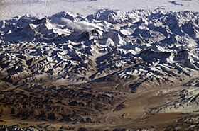
The Himal region is Nepal's snowy mountain area. It starts where high ridges begin rising above 3,000 metres (10,000 ft), leading into very cold zones used for grazing animals in summer. This region makes up about 15% of Nepal's land. The highest Himalayas rise sharply here, with the permanent snow line starting between 5,000 to 5,500 metres (16,400 to 18,000 ft). Nepal has about 90 peaks taller than 7,000 metres (23,000 ft), and eight of them are over 8,000 metres (26,247 ft)! These include Mount Everest (8,848 metres (29,029 ft)) and Kanchenjunga (8,598 metres (28,209 ft)).
Many famous mountain ranges are found here, like the Mahalangur Himal (home to Mount Everest), Annapurna, and Dhaulagiri. These ranges are popular for mountaineering and trekking.
| Mountain | Height | Section | Location | |
|---|---|---|---|---|
| Mount Everest (Highest in the world) |
8,848 m | 29,029 ft | Khumbu Mahalangur | Khumbu Pasanglhamu, Solukhumbu District, Province No. 1 (Nepal-China Border) |
| Kangchenjunga (3rd highest in the world) |
8,586 m | 28,169 ft | Northern Kanchenjunga | Phaktanglung / Sirijangha, Taplejung District, Province No. 1 (Nepal-India Border) |
| Lhotse (4th highest in the world) |
8,516 m | 27,940 ft | Everest Group | Khumbu Pasanglhamu, Solukhumbu District, Province No. 1 (Nepal-China Border) |
| Makalu (5th highest in the world) |
8,462 m | 27,762 ft | Makalu Mahalangur | Makalu, Sankhuwasabha District, Province No. 1 (Nepal-China Border) |
| Cho Oyu (6th highest in the world) |
8,201 m | 26,906 ft | Khumbu Mahalangur | Khumbu Pasanglhamu, Solukhumbu District, Province No. 1 (Nepal-China Border) |
| Dhaulagiri (7th highest in the world) |
8,167 m | 26,795 ft | Dhaulagiri | Dhaulagiri, Myagdi District,
Gandaki Province |
| Manaslu (8th highest in the world) |
8,163 m | 26,759 ft | Mansiri Himal | Tsum Nubri, Gorkha District / Nashong, Manang District,
Gandaki Province |
| Annapurna (10th highest in the world) |
8,091 m | 26,545 ft | Annapurna Massif | Annapurna, Kaski District / Annapurna, Myagdi District,
Gandaki Province |
Trans-Himalayan Valleys
North of the highest mountains, there are special alpine valleys like Humla, Mustang, and Khumbu. These valleys are often dry and are located between or north of the main Himalayan ranges.
Historically, some of these valleys were easier to reach from Tibet. People living here, like the famous Sherpas near Mount Everest, have strong cultural ties to Tibet. They have kept many traditional ways of life. Other valleys, like the Kali Gandaki Gorge, show a mix of both Nepali and Tibetan cultures.
People live in permanent villages as high as 4,500 metres (15,000 ft), and some even have summer camps higher up. They raise yaks and grow crops that can handle the cold, like potatoes and barley. In the past, they traded goods like salt from Tibet for rice from Nepal's lowlands. Today, many work in tourism, helping climbers and trekkers explore the mountains.
The Hilly Region: Middle Hills
The Hilly region is a mountainous area south of the snowy Himal region. It generally doesn't have permanent snow. This region starts with hills that rise 1,000 to 1,500 metres (3,000 to 5,000 ft) high and covers 68% of Nepal's total land area.
The steep southern slopes are mostly empty, acting as a natural barrier between different cultures. People called Paharis live mainly in river valleys, where they grow rice, wheat, and potatoes. Important cities like Kathmandu and Pokhara are in this region. The Newar people, who have their own language, are native to the Kathmandu Valley and have spread to other towns.
Many other local ethnic groups, like the Magar, Gurung, and Tamang, live on the hillsides, speaking their own languages. Farmers here grow fruits and other crops. As you go higher, people raise more animals, moving their herds to lower areas in winter. Because it's harder to grow enough food in some higher areas, many people move to find work.
The Hilly region ends where the land rises above 3,000 metres (10,000 ft), entering the colder subalpine zone.
The Terai Region: Lowlands
The Terai is a low-lying region with some hills, covering 17% of Nepal's total area. This region starts at the Indian border and includes the flat, farmed Gangetic Plain. In the past, timber and other resources were sent to India. Industries based on farm products, like jute, started in the 1930s.
The Outer Terai shares more culture with nearby parts of India than with Nepal's Hilly region. While Nepali is taught in schools, local people often speak Maithali, Bhojpuri, and Tharu languages.
The Outer Terai ends at the base of the first hills, called the Chure Hills. These hills have thick forests at their base. Below these forests, groundwater comes to the surface, creating marshy areas. Historically, these wet areas were challenging to settle due to certain diseases.
Beyond the Chure Hills, there are valleys called Inner Terai. These valleys have good soil. In the mid-1950s, efforts were made to control mosquitoes, which made these valleys safer for settlement. This led to more people moving from the hills to these fertile areas.
The Terai region ends and the Hilly region begins at a higher range of foothills called the Lower Himalayan Range.
Nepal's Climate Zones
Nepal's location is similar to Florida in the United States. However, with elevations from less than 100 meters (300 ft) to over 8,000 meters (26,000 ft), Nepal has eight climate zones. These range from tropical to areas of permanent snow.
The tropical zone is below 1,000 meters (3,300 ft). It rarely experiences frost. This zone is perfect for growing fruits like mangoes, papayas, and bananas. Winter crops, like grains and vegetables, also thrive here. The Outer Terai and Inner Terai valleys are mostly in this zone.
The subtropical climate zone is between 1,000 to 2,000 meters (3,300 to 6,600 ft). It covers 22% of Nepal and is common in the Middle Hills. Frost can occur here, but it varies. Crops like rice, maize, millet, wheat, and various fruits grow well. Most of Nepal's population lives in the tropical and subtropical zones.
The temperate climate zone is from 2,000 to 3,000 meters (6,600 to 9,800 ft). It makes up 12% of Nepal's land. This zone has more frost days. Farmers grow cold-tolerant crops such as rice, maize, wheat, barley, potatoes, and apples.
The subalpine zone is from 3,000 to 4,000 meters (9,800 to 13,100 ft). It covers 9% of Nepal, mainly in the Mountain and Himalayan regions. Some people live here permanently, but many areas are used seasonally for grazing sheep, goats, and yaks. Crops like barley, potatoes, and apples are grown.
The alpine zone is from 4,000 to 5,000 meters (13,100 to 16,400 ft). It covers 8% of the country. There are very few permanent settlements above 4,000 meters. Little farming happens here, but medicinal herbs are gathered, and animals graze in warmer months.
Above 5,000 meters (16,400 ft), the climate is nival, meaning it's always snowy. No humans live or use these areas, even seasonally.
In the dry areas behind the high mountains, there is a Transhimalayan climate. It's like a cold desert. Few people live here, and farming depends on water from melting snow and streams.
Rainfall generally decreases from east to west across Nepal. Eastern Nepal gets about 2,500 mm (100 in) of rain annually, while western Nepal gets about 1,000 mm (40 in). However, some windward slopes can receive as much as 5,500 mm (18 ft) of rain. In contrast, very dry areas behind the high mountains can get as little as 160 mm (6 in).
Nepal's Seasons
The year has a wet season from June to September and a dry season from October to June. The summer warmth in Inner Asia creates a low-pressure area that pulls moist air from the Indian Ocean, bringing the monsoon. April and May are very dry and hot, especially in the tropical areas.
The summer monsoon often starts with thunderstorms, which help prepare rice fields. Heavy rains usually arrive in mid-June. Too much rain can cause floods and landslides, damaging homes and farms. The monsoon also makes transportation difficult, as roads can wash out.
Rains usually stop by mid-October, bringing cool, clear, and dry weather. This is a joyful time in Nepal, as harvests are complete, and major festivals like Dashain and Tihar are celebrated. This pleasant weather lasts until about December.
After this, the winter monsoon brings occasional rain to the lowlands and snow to high-altitude areas. The Himalayas block cold air from Inner Asia, making winters in southern Nepal warmer than they would otherwise be.
Nepal's Environment
The big changes in elevation create many different natural environments, or biomes. These range from tropical grasslands near the Indian border to subtropical and temperate forests in the hills, and finally to rocky, icy areas at the highest elevations.
Subtropical forests are common in the lower parts of the Hilly region. At higher elevations, up to 3,000 metres (10,000 ft), you find temperate forests. The native forests in the Mountain region change from east to west as rainfall decreases.
Environmental Challenges
Nepal faces several environmental challenges. These include natural events like earthquakes, severe thunderstorms, flooding, and landslides. The timing and amount of summer monsoon rains can also lead to droughts.
Human activities also cause problems. Deforestation is a big issue, mainly because people cut down too many trees for firewood and illegal logging. Clearing land for farming and new buildings also reduces forest cover. Water pollution from human and animal waste, farm runoff, and industrial waste is another concern. Protecting wildlife is also important.
Nepal's River Systems
Nepal has three main types of rivers. The largest systems, from east to west, are the Koshi, Gandaki/Narayani, Karnali/Goghra, and Mahakali. These rivers start high in the Himalayas and get a lot of water from melting snow, even before the summer monsoon. They flow through deep gorges in the mountains and then spread out onto the plains.
The Koshi River is also called Sapta Koshi because it has seven Himalayan branches in eastern Nepal. One of its branches, the Arun, starts in Tibet, far beyond Nepal's northern border.
The Gandaki/Narayani also has seven Himalayan branches in central Nepal. The Kali Gandaki flows through the world's deepest valley, between the 8,000-meter Dhaulagiri and Annapurna ranges.
The Karnali drains western Nepal. Its upper part starts in Tibet, near the sacred Lake Manasarovar and Mount Kailash. This area is very important as it's where several major rivers of South Asia begin. The Mahakali River, which forms part of the Nepal-India border, joins the Karnali in India.
Second category rivers start in the Middle Hills and Lower Himalayan Range. Examples include the Bagmati, which flows through Kathmandu Valley. These rivers don't have glacial sources, so their water levels change more throughout the year.
Third category rivers start in the outermost Siwalik Hills and often dry up during parts of the year.
None of Nepal's river systems are used much for large-scale commercial shipping. Instead, the deep river gorges make it hard to build roads and connect different parts of the country. Footpaths are still the main way to travel in many hilly areas.
Managing Rivers
Rivers in Nepal can cause serious floods. For example, the Koshi River caused a big flood in India in 2008 after breaking through an embankment. Rivers in the Terai region are known for flash floods.
Because the Himalayas are constantly rising, millions of tons of sediment wash down from the mountains each year. This sediment settles on the plains, causing rivers to change course often. This makes it challenging to control flooding with man-made walls.
Building large reservoirs in the Middle Hills could help. These reservoirs could capture extra water during the summer monsoon, reducing floods downstream. They could also store water for irrigation during the dry season and generate electricity. Water for irrigation is especially important for farming in the Indian plains.
However, building dams in Nepal is complicated. First, the region has many earthquakes, and a dam failure could be disastrous. Second, global warming has created new glacial lakes that could burst and cause floods. Third, rivers carry a lot of sediment, which can quickly fill up reservoirs. Finally, there are challenges in fairly sharing the costs and benefits of these projects between Nepal and India.
Nepal's Area
- Total: 147,516 km2 (56,956 sq mi)
- Land: 143,181 km2 (55,282 sq mi)
- Water: 4,000 km2 (1,544 sq mi)
Nepal is a landlocked country, meaning it has 0 km of coastline.
- Lowest point: Kechana Kawal, Jhapa District 59 metres (194 ft)
- Highest point: Sagarmatha (Mount Everest) 8,848 metres (29,029 ft)
Resources and Land Use
Nepal has natural resources like quartz, water, timber, and hydropower. It also has beautiful scenery and small amounts of lignite, copper, cobalt, and iron ore.
- Arable land (land suitable for growing crops): 16.0%
- Permanent crops: 0.8%
- Other land: 83.2% (as of 2001)
- Irrigated land: 11,680 square kilometres (4,510 sq mi) (as of 2003), which is nearly 50% of arable land.
- Renewable water resources: 210.2 cubic kilometres (50.4 cu mi) (as of 2011)
Land Cover and Forests
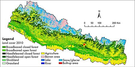
According to a 2010 study, forests are the most common type of land cover in Nepal, covering 57,538 square kilometres (22,216 sq mi) or 39.09% of the country. Most of this is broadleaved forest. Farmland is also very common, covering 43,910 square kilometres (16,950 sq mi) or 29.83%. The high mountain areas are mostly covered by snow, glaciers, and barren land.
The Hill region is the largest part of Nepal, covering 29.5% of the country. It has a lot of cultivated land and natural plants. The Terai region has more cultivated land and less natural vegetation. The High mountain region has many natural water bodies, snow, glaciers, and barren areas.
Nepal's Forests
As of 2005, about 25.4% of Nepal's land, or 36,360 km2 (14,039 sq mi), was covered with forest. About 9.6% of this was primary forest, which means it was relatively untouched. Between 2000 and 2005, Nepal lost about 2,640 km2 (1,019 sq mi) of forest, mainly due to deforestation.
More recent figures from 2010 show that forests cover 39.09% of Nepal. Most of these are broadleaved forests. About 64.8% of the forested area consists of large, connected forests.
Deforestation is caused by many things. People cut down too much wood for firewood, even though other energy sources are available. Firewood still provides 80% of Nepal's energy for heating and cooking. Cutting timber for construction and branches for animal food also harms forests.
Illegal logging is a problem, especially in the Siwalik Hills, where wood is sometimes smuggled into India. Forests are also cleared to make space for new settlements, farms, cities, and buildings like schools and hospitals. In the mountains, building hotels and trekking trails can lead to deforestation, and over-grazing by animals can degrade the land.
Nepal's Borders
- Total border length: 2,926 kilometres (1,818 mi)
- Border countries: China 1,236 kilometres (768 mi), India 1,690 kilometres (1,050 mi)
Border Crossings with India
India and Nepal have an open border, meaning citizens can move freely between the two countries. However, there are 23 checkpoints for trade. Six of these are also used by people from other countries.
| Crossing Name |
Crossing Location |
Nepali town | District | Province | Indian town | District | State |
|---|---|---|---|---|---|---|---|
| Pashupatinagar | 26°56′54″N 88°07′20″E / 26.94833°N 88.12222°E | Pashupatinagar | Ilam | Province No. 1 | Sukhiapokhri | Darjeeling | West Bengal |
| Mechi | 26°38′41″N 88°09′43″E / 26.64472°N 88.16194°E | Kakarbhitta | Jhapa | Province No. 1 | Naxalbari (Panitanki) | Darjeeling district | West Bengal |
| 26°32′50″N 88°06′36″E / 26.54722°N 88.11000°E | Bhadrapur | Jhapa district | Province No. 1 | Galgalia | Kishanganj | Bihar | |
| Biratnagar | 26°24′09″N 87°15′57″E / 26.40250°N 87.26583°E | Biratnagar | Morang | Province No. 1 | Jogbani | Araria | Bihar |
| Sunsari | 26°31′07″N 86°57′04″E / 26.51861°N 86.95111°E | Sunsari | Province No. 1 | Bhimnagar | Supaul | Bihar | |
| Rajbiraj | 26°27′00″N 86°47′34″E / 26.45000°N 86.79278°E | Rajbiraj | Saptari | Province No. 2 | Kunauli | Supaul District | Bihar |
| Siraha | 26°36′22″N 86°08′14″E / 26.60611°N 86.13722°E | Siraha | Siraha | Province No. 2 | Jayanagar | Madhubani | Bihar |
| 26°39′29″N 86°04′04″E / 26.65806°N 86.06778°E | Thadi Jhijha | Dhanusa | Province No. 2 | Laukaha | Madhubani district | Bihar | |
| Jaleshwar | Jaleswar | Mahottari | Province No. 2 | Sursand | Sitamarhi | Bihar | |
| Malangawa | Sarlahi | Province No. 2 | Sonbarsa | Sitamarhi district | Bihar | ||
| Gaur | Gaur | Rautahat | Province No. 2 | Bairgania | Sitamarhi district | Bihar | |
| Birganj | Birganj | Parsa | Province No. 2 | Raxaul | East Champaran | Bihar | |
| Parasi | Mahespur | Thutibari | Maharajganj | Uttar Pradesh | |||
| Bhairahawa | Siddharthanagar (Bhairahawa) |
Rupandehi | Lumbini Province | Nautanwa | Maharajganj | Uttar Pradesh | |
| Taulihawa-Siddharthnagar | 27°27′30″N 82°59′40″E / 27.45833°N 82.99444°E | Taulihawa | Kapilvastu | Lumbini Province | Khunwa | Siddharthanagar | Uttar Pradesh |
| Krishnanagar | Krishnanagar | Kapilvastu District | Lumbini Province | Barhni | Siddharthnagar district | Uttar Pradesh | |
| Koilabas | Koilabas | Dang | Lumbini Province | Jarwa | Balrampur | Uttar Pradesh | |
| Nepalganj | Nepalganj | Banke | Lumbini Province | Rupaidiha | Bahraich | Uttar Pradesh | |
| Rajapur | Rajapur | Bardiya | Lumbini Province | Katerniyaghat | Bahraich district | Uttar Pradesh | |
| Prithivipur (Sati) | Kailali | Sudurpashchim Province | Tikonia | Lakhimpur Kheri | Uttar Pradesh | ||
| Dhangadhi | Kailali District | Sudurpashchim Province | Gauriphanta | Lakhimpur Kheri district | Uttar Pradesh | ||
| Bhim Datta (Mahendranagar) |
Kanchanpur | Sudurpashchim Province | Banbasa | Champawat | Uttarakhand | ||
| Mahakali | Mahakali | Baitadi | Sudurpashchim Province | Jhulaghat (Pithoragarh) | Pithoragarh | Uttarakhand | |
| Darchula | Darchula | Sudurpashchim Province | Dharchula | Pithoragarh district | Uttarakhand |
Border Crossings with China
| Crossing Name (Other Name) |
Nepali Jurisdiction | Chinese Jurisdiction | Status | Crossing Location |
Border elevation |
|---|---|---|---|---|---|
| Burang–Yari (Xieerwa) |
Hilsa, Humla District | Burang, Burang County | Active | 30°09′12″N 81°20′00″E / 30.15333°N 81.33333°E | 3,640 m (11,900 ft) |
| Lizi—Nechung (Kora La) |
Lo Manthang, Mustang District | Zhongba County | Planned | 29°19′24″N 83°59′09″E / 29.32333°N 83.98583°E | 4,620 m (15,200 ft) |
| Gyirong–Rasuwa | Rasuwa Gadhi, Rasuwa District | Gyirong, Gyirong County | Active | 28°16′45″N 85°22′43″E / 28.27917°N 85.37861°E | 1,850 m (6,100 ft) |
| Zhangmu–Kodari | Tatopani, Sindhupalchok District | Zhangmu, Nyalam County | Active | 27°58′24″N 85°57′50″E / 27.97333°N 85.96389°E | 1,760 m (5,800 ft) |
| Chentang–Kimathanka | Kimathanka, Sankhuwasabha District | Chentang, Dinggyê County | Planned | 27°51′30″N 87°25′30″E / 27.85833°N 87.42500°E | 2,248 m (7,400 ft) |
| Ri'og–Olangchung Gola (Tipta La) |
Olangchung Gola, Taplejung District | Ri'og, Dinggyê County | Planned | 27°49′00″N 87°44′00″E / 27.81667°N 87.73333°E | 5,095 m (16,700 ft) |
See also
 In Spanish: Geografía de Nepal para niños
- Geology of Nepal
- List of mountains in Nepal
- Valleys of Nepal
 | Calvin Brent |
 | Walter T. Bailey |
 | Martha Cassell Thompson |
 | Alberta Jeannette Cassell |


