
Bihar facts for kids
Quick facts for kids
Bihar
|
||
|---|---|---|
 .jpg)   Clockwise from top: Great Buddha Statue at Bodh Gaya, ruins of ancient Nalanda University, Madhubani painting from Mithila region, Brahma Kund hot springs in Rajgir
|
||
|
||

Location of Bihar in India
|
||
| Country | India | |
| Formation |
|
|
| Statehood | 26 January 1950 | |
| Capital | Patna | |
| Largest city | Patna | |
| Districts | 38 | |
| Area | ||
| • Total | 94,163 km2 (36,357 sq mi) | |
| Area rank | 12th | |
| Population
(2011)
|
||
| • Total | 103,804,637 | |
| • Rank | 3rd | |
| • Density | 1,102/km2 (2,850/sq mi) | |
| • Major Ethnolinguistic Groups | Bhojpuris Maithils Magahis | |
| Demonym(s) | Bihari | |
| GDP (2017–18) | ||
| • Total | ₹4.88 lakh crore (US$83 billion) | |
| • Per capita | ₹38,860 (US$660) | |
| Languages | ||
| • Official | Hindi | |
| • Additional official | Maithilia, Urdub | |
| Time zone | UTC+05:30 (IST) | |
| UN/LOCODE | INBR | |
| ISO 3166 code | IN-BR | |
| Vehicle registration | BR | |
| HDI (2017) | ||
| Literacy (2011) | 63.82% | |
| Sex ratio (2011) | 918 ♀/1000 ♂ | |
|
||

Bihar is a state located in the eastern part of India. It covers a large area of about 94,163 square kilometers. To give you an idea, it's bigger than the country of Hungary but a bit smaller than South Korea.
The capital city of Bihar is Patna. This state shares its borders with other Indian states: Uttar Pradesh to the west, Jharkhand to the south, and West Bengal to the east. To the north, Bihar borders the country of Nepal. Bihar is an important part of the East Indian region. It is a developing state that is working to grow and improve.
Contents
Bihar's Special Symbols
Every state has its own special symbols, and Bihar is no different! These symbols represent the state's unique nature and culture.
Bihar's Provincial Bird
The provincial bird of Bihar is the Indian Roller. This beautiful bird is known for its bright blue feathers. It often performs amazing aerial displays, especially during its breeding season.
Bihar's Provincial Animal
The Gaur, also known as the Indian bison, is the provincial animal of Bihar. Gaurs are very large and strong wild cattle. They are known for their impressive size and powerful build.
Bihar's Provincial Tree
The Sacred Fig, or Pipal tree, is the provincial tree of Bihar. This tree is very important in Indian culture and religion. It is often seen near temples and is known for its wide, spreading branches.
Bihar's Provincial Flower
The White Orchid-tree is the provincial flower of Bihar. This flower is lovely with its delicate white petals. It adds beauty to the landscapes of the state.
-
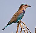
Indian Roller, Provincial bird of Bihar
-
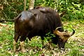
Gaur or Indian bison, Provincial animal of Bihar
-
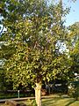
Sacred fig, Provincial tree of Bihar
-
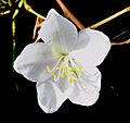
White Orchid-tree, Provincial flower of Bihar

_1_by_N._A._Naseer.jpg)


Images for kids
-
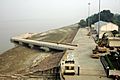
Patna river port on national inland waterways-1 at Gai Ghat

See also
 In Spanish: Bihar para niños
