
Bangladesh facts for kids
Quick facts for kids
People's Republic of Bangladesh
|
|
|---|---|
|
Government Seal
|
|
.svg) Show globe Show globe Show map of Bangladesh Show map of Bangladesh |
|
| Capital and largest city
|
Dhaka 23°45′50″N 90°23′20″E / 23.76389°N 90.38889°E |
| Official language and national language |
Bengali |
| Other common language | English |
| Ethnic groups
(2022)
|
99% Bengali |
| Religion
(2022)
|
|
| Demonym(s) | Bangladeshi |
| Government | Unitary parliamentary republic |
| Mohammed Shahabuddin | |
|
• Chief Adviser (Interim Government)
|
Muhammad Yunus |
| Zubayer Rahman Chowdhury | |
| Legislature | Jatiya Sangsad |
| Independence
from Pakistan
|
|
| 15 August 1947 | |
| 14 October 1955 | |
|
• Proclamation of independence
|
26 March 1971 |
|
• Provisional government
|
10 April 1971 |
|
• Victory in the Liberation War
|
16 December 1971 |
|
• Current constitution
|
16 December 1972 |
| Area | |
|
• Total
|
148,460 km2 (57,320 sq mi) (92nd) |
|
• Water (%)
|
6.4 |
|
• Land area
|
130,170 km2 |
|
• Water area
|
18,290 km2 |
| Population | |
|
• 2024 estimate
|
173,562,364 (8th) |
|
• 2022 census
|
169,828,911 (8th) |
|
• Density
|
1,165/km2 (3,017.3/sq mi) (13th) |
| GDP (PPP) | 2025 estimate |
|
• Total
|
|
|
• Per capita
|
|
| GDP (nominal) | 2025 estimate |
|
• Total
|
|
|
• Per capita
|
|
| Gini (2025) | ▼ 33.4 medium |
| HDI (2023) | medium · 130th |
| Currency | Taka (৳) (BDT) |
| Time zone | UTC+6 (BST) |
| Date format | dd/mm/yyyy |
| Driving side | Left |
| Calling code | +880 |
| ISO 3166 code | BD |
| Internet TLD |
|


Bangladesh (officially called People's Republic of Bangladesh) is a country in South Asia. It is located next to India and Myanmar. Its capital and largest city is Dhaka. Bangladesh is surrounded by India on three sides. Myanmar is to its southeast. It is also close to China, Bhutan, Sikkim, and Nepal.
Bangladesh became fully independent from Pakistan in 1971 after a war where many lives were lost. After the war, the Bengali people formed their own country. The local money is called Taka. The official language is Bengali.
Two major rivers, the Ganges and Brahmaputra Rivers, flow through Bangladesh. These rivers are considered holy by Hindus. Because of these rivers, floods are common.
Contents
History of Bangladesh
.jpg)
Ancient Times
The land of Bangladesh has been lived on for thousands of years. People started farming very early here. Around 500 BC, they began growing rice. This led to the growth of cities. Houses were built from wood and mud because there was no stone. Not much is left from these early times due to the monsoon climate. From about 300 BC to the 1700s AD, writing, the Bengali language, and different religions grew here. By the 1500s, the area was rich, and even farmers had plenty of food.
Becoming a Nation
For a long time, this area was known as "Bengal" and was part of India. Over the last few centuries, different foreign powers got involved, leading to wars. In the 20th century, there were more wars and political changes.
Bengal was ruled by the British from 1757 to 1947. It was part of British India. In 1947, a new country called Pakistan was formed. It included East Bengal and West Pakistan. These two parts were far apart, separated by India. In 1949, the Awami League formed to push for East Bengal to separate from West Pakistan. In 1955, East Bengal was renamed East Pakistan. Dhaka became an important city for the Pakistani Bengal region.
The people of East Pakistan were mostly Bengalis. They had a different language and culture from the people in West Pakistan. These differences led to the Bangladesh Liberation War. On December 16, 1971, Bangladesh became independent. This happened with the help of allied forces against West Pakistani forces.
After Bangladesh became a country, Bengali became the main language. It was used in schools, business, and government. English was still taught in higher education. Later, Arabic also became more important, especially for understanding religious texts.
Government and Politics
Bangladesh is a unitary parliamentary republic. This means it has a government where people vote for their representatives. The government has three main parts:
- The executive part runs the country day-to-day. The Chief Adviser leads this part and works with a cabinet of ministers.
- The legislative part is called the Jatiya Sangsad (House of the Nation). People vote to elect members of parliament (MPs). These MPs make the laws for the country.
- The judiciary part makes sure laws are followed and helps solve disagreements. The Supreme Court is the highest court.
The Awami League (AL) and the Bangladesh Nationalist Party (BNP) are two of the main political parties in Bangladesh.
Geography of Bangladesh

Bangladesh is a small, green country in South Asia. It is located on the Bay of Bengal. It is mostly surrounded by India and has a small border with Myanmar to the southeast. It is also close to Nepal, Bhutan, and China.
The country has three main areas. Most of Bangladesh is a very fertile river delta, which is the largest in the world. The northwest and central parts have plateaus. The northeast and southeast have green hills.
The Ganges delta is formed by the Ganges, Brahmaputra River, and Meghna Rivers joining together. Bangladesh is known as the "Land of Rivers" because over 57 rivers flow through it. This means water issues are important, especially with India.
Most of Bangladesh is flat and fertile land. Much of it is less than 12 meters (39 feet) above sea level. If sea levels rise by 1 meter (3 feet), about 10% of the land could be flooded. Forests cover 17% of the country, and hills cover 12%. The country's wetlands are very important for the environment. The highest point in Bangladesh is Saka Haphong, which is 1,064 meters (3,491 feet) high.
Amazing Wildlife

Bangladesh has a rich variety of plants and animals. It has a long coastline, many rivers, lakes, and different types of forests. The flat land is known for its fertile soil, which is great for farming.
The country is full of green plants, with villages often hidden among groves of mango, jackfruit, bamboo, and coconut trees. There are about 6,000 types of plants, including 5,000 flowering plants. Water lilies and lotuses grow beautifully during the monsoon season. Bangladesh has 50 places set aside to protect wildlife.
A large part of the Sundarbans, the world's biggest mangrove forest, is in Bangladesh. This forest is a UNESCO World Heritage Site. It is home to many animals like the Bengal tiger, clouded leopard, and saltwater crocodile. Northern and eastern Bangladesh have Asian elephants and hoolock gibbons.
Other animals include deer, foxes, wild boars, and pythons. Bangladesh also has many Irrawaddy dolphins and Ganges dolphins. There are many kinds of amphibians, reptiles, and birds, with 628 species of birds found here.
Regions of Bangladesh

Bangladesh is split into eight main areas called divisions:
These divisions are then divided into 64 districts.
Dhaka is the capital and largest city. Other big cities include Chittagong, Khulna, Rajshahi, Sylhet, Barisal, and Rangpur.
| City | City population (2008 estimate) | Metro population (2008 estimate) |
|---|---|---|
| Dhaka | 7,000,940 | 12,797,394 |
| Chittagong | 2,579,107 | 3,858,093 |
| Khulna | 855,650 | 1,588,425 |
| Rajshahi | 472,775 | 775,496 |
| Sylhet | 463,198 | – |
| Barisal | 210,374 | – |
| Rangpur | 241,310 (2001) | 251,699 (2001) |
Religions in Bangladesh
The main religion in Bangladesh is Islam, followed by about 91% of the people. Many people also follow Hinduism, which is about 8% of the population. Most Muslims are Sunni. Islam became the official state religion in the 1980s. Christians make up less than 1% of the population.
Culture of Bangladesh
The oldest writings in Bengali are from the 8th century. Later Bengali literature often had religious themes. Important poets from the 19th century include Rabindranath Tagore and Kazi Nazrul Islam.
Bangladeshi music often focuses on lyrics and uses few instruments. Folk music is sometimes played with an ektara, which is an instrument with only one string. Bangladeshi dances come from folk traditions.
Bangladesh makes about 80 films each year. Movies from India are also very popular. Around 200 daily newspapers and over 500 magazines are published in Bangladesh.
Rice and fish are popular traditional foods. Biryani is also a favorite dish.
The sari is the most common dress for women in Bangladesh. The salwar kameez is also popular, especially among younger women. In cities, some women wear Western clothes. Men often wear Western clothes.
Eid ul-Fitr and Eid ul-Adha are major Muslim festivals. Vesak, which celebrates the birth of Gautama Buddha, and Christmas (called Bôŗodin) are national holidays. The most important non-religious festival is Pohela Boishakh, which is the Bengali New Year.
Sports in Bangladesh
Cricket is the most popular sport in Bangladesh. Football (soccer) is also very popular. The Bangladesh national cricket team played in their first Cricket World Cup in 1999. In 2011, Bangladesh helped host the ICC Cricket World Cup 2011.
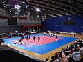
Hadudu (kabaddi) is the national sport of Bangladesh. Other popular sports include field hockey, tennis, badminton, handball, basketball, volleyball, chess, shooting, angling, and carrom.
National Symbols of Bangladesh
-
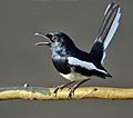
Magpie-robin, National bird Of Bangladesh
-
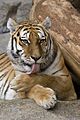
Royal Bengal Tiger, National animal Of Bangladesh
-
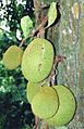
Jackfruit (Artocarpus heterophyllus), National fruit Of Bangladesh
-
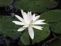
Water lily, National flower Of Bangladesh
-
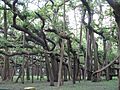
Banyan, National tree Of Bangladesh
-
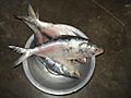
Ilish, National fish Of Bangladesh
-
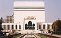
Baitul Mukarram, National mosque Of Bangladesh
-
Hadudu(Kabaddi), National sport Of Bangladesh
-
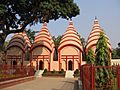
National temple Of Bangladesh
-_Male_calling_in_the_rain_at_Kolkata_I_IMG_3746.jpg)


Challenges in Bangladesh
Bangladesh still faces challenges, like poverty and some political issues. More than half of the people can now read and write.
The country often has strong cyclones and natural disasters. These storms can cause a lot of damage and loss of life. Bangladesh is one of the most crowded countries in the world. Cyclones are common in the Bay of Bengal, especially in the south. Even with many storms, Bangladesh is working to improve its storm prevention systems.
Health and Cleanliness

One big challenge is making sure everyone has clean water and good sanitation. Many areas do not have safe drinking water or proper toilets and sewage systems.
- Lack of toilets can lead to diseases like diarrhea and typhoid fever.
- Many homes in rural areas do not have good air flow or lighting.
- Public eating places and markets sometimes lack good hygiene.
- There are issues with drainage and getting rid of trash and animal waste.
- People in rural areas need more education about health.
- It can be hard for public health workers to reach some areas due to poor roads.
Related Pages
Images for kids
-
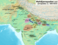
Vanga Kingdom and its neighbors in ancient South Asia
-
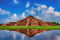
7th century Buddhist monastery, known as Somapura Mahavihara
-
The Pala Empire was a powerful kingdom in Bengal during the Late Classical period.
-
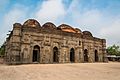
The Sixty Dome Mosque is the largest mosque in the UNESCO protected Mosque City of Bagerhat.
-
Choto Sona Mosque, built during the reign of Sultan Alauddin Hussain Shah.
-
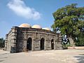
Kusumba Mosque
-

Shipbuilding was a big industry in the Bengal Sultanate.
-
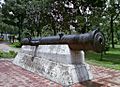
The Bibi Mariam Cannon was used by the Mughals to defend their bases.
-
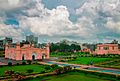
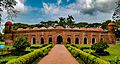
Lalbagh Fort was the home of the Mughal viceroy Shaista Khan.
-
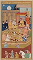
Portuguese visitors at the court of emperor Akbar.
-
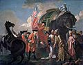
Lord Clive meeting with Mir Jafar after the Battle of Plassey.
-

Founding meeting of the All-India Muslim League in Dhaka, 1906.
-
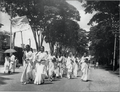
Women students of Dhaka University marching during the Bengali Language Movement in 1953.
-
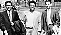
Sheikh Mujibur Rahman (left) visiting a student at Harvard in the 1950s.
-
Sheikh Mujib voting in a general election. He is seen as Bangladesh's founding leader.
-
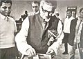
Ziaur Rahman with members of the Dutch royal family in 1978.
-

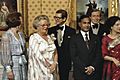
Muhammad Yunus celebrating the Nobel Peace Prize in 2006.
-
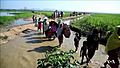
Rohingya refugees entering Bangladesh from Myanmar.
-
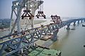
Construction of Padma Bridge, the longest bridge on the Ganges.
-
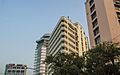
Hotels and office blocks in a nice neighborhood of Dhaka.
-
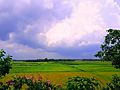
Paddy fields are common farmlands. Bangladesh is a top producer of rice, potatoes, and fruits.
-
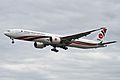
A Boeing 777 from Biman Bangladesh Airlines, the national airline.
-

In 2018, the first Bangabandhu-1 satellite was launched.
-
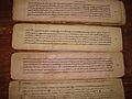
The Charyapada scrolls are the oldest Bengali language texts.
-
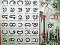
Chakma alphabets are native to the Chittagong Hill Tracts.
-
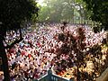
Eid prayers for Muslims at Barashalghar, Comilla.
-
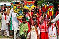
Bangladeshis celebrating Pohela Boishakh as the start of the Bengali new year.
-
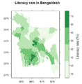
Literacy rates in Bangladesh districts.
-
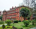
Faculty of Sciences at the University of Dhaka.
-
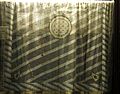
A preserved cloth of historic fine Bengali muslin.
-
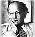
Syed Mujtaba Ali
-
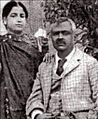
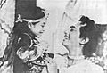
Muslim feminist Begum Rokeya and her husband in 1898.
-
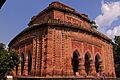
The 18th century terracotta Hindu Kantanagar Temple in Dinajpur.
-
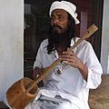
A Baul from Lalon Shah's shrine in Kushtia.
-
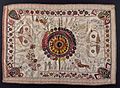
Embroidery on Nakshi kantha (embroidered quilt), an old Bengali art tradition.
-
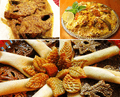
Traditional Bangladeshi Meal: Mustard seed Ilish Curry, Dhakai Biryani and Pitha.
-
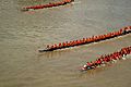
A Nouka Baich boat race.
-
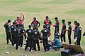
Bangladesh team practicing at Sher-e-Bangla National Cricket Stadium.
-
Anwar Hossain playing Siraj ud-Daulah, the last independent Nawab of Bengal, in a 1967 film.
-
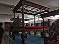
Beds of zamindars kept at the Bangladesh National Museum.
.png)


.jpg)


_en_echtgenot,_Bestanddeelnr_253-8087.jpg)


.jpg)

.jpg)
.jpg)


.jpg)


_LACMA_AC1994.131.1.jpg)

_(9903944955).jpg)
.jpg)
.jpg)

See also
 In Spanish: Bangladés para niños
