List of rivers of Bangladesh facts for kids
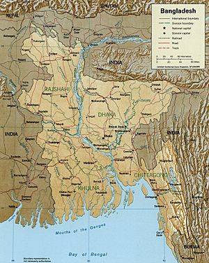
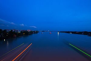
Bangladesh is a country full of rivers! It's often called a "riverine country" because rivers are so important to its land and culture. Many rivers flow through Bangladesh, though the exact number can be tricky to count. Some sources say there are around 907 rivers, while others mention fewer, like 310 or 405. This difference happens because rivers can change their paths over time and some smaller streams might dry up.
Historically, there were even more rivers, perhaps 700 to 800, but many have disappeared due to pollution or lack of care. Also, the same river might have different names in various areas, which adds to the confusion. Sadly, about 17 rivers are currently close to vanishing.
Many rivers in Bangladesh come from other countries. About 57 international rivers flow into Bangladesh, with 54 coming from India and 3 from Myanmar. The three biggest rivers in Bangladesh are the Jamuna, the Padma, and the Meghna. The Jamuna, which is part of the Brahmaputra River, is the longest. The Padma is the fastest-flowing, and the Meghna is the widest.
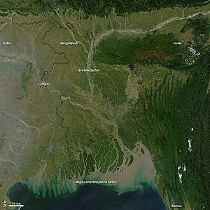
These rivers have played a huge role in shaping Bangladesh. Most of the country's land has been formed by the silt (fine soil) that the rivers carry. Bangladesh is located in the world's largest river delta system, called the Ganges Delta.
Contents
Important Rivers in Bangladesh
Bangladesh has many important rivers. Here are some of the major ones:
- Atrai River
- Arialkha River
- Balu River
- Bangali River
- Bangshi River
- Baral River
- Bhairab River
- Biskhali River
- Brahmaputra River
- Buriganga River
- Chiknai River
- Chitra River
- Dakatia River
- Dhaleshwari River
- Dhanu River
- Feni River
- Ganges River
- Garai River
- Gomti River
- Halda River
- Ichhamati River
- Jamuna River
- Karatoya River
- Karnaphuli River
- Kushiyara River
- Meghna River
- Naf River
- Padma River
- Sangu River
- Surma River
- Teesta River
- Titas River
Ganges-Brahmaputra Delta System
A large part of Bangladesh's land is made up of the Ganges-Brahmaputra Delta. This is a huge, flat area of land created by the rivers depositing silt.
When the Ganges River flows out of India and into Bangladesh, its main channel becomes known as the Padma River. Similarly, after the Brahmaputra River joins with the Teesta River, its main channel is called the Jamuna River. These rivers create a vast network of waterways across the country.
Rivers in Bogra District
The Bogra district has several rivers. The Karatoya River acts like a central dividing line. Rivers to the east include the Monas, Charkadaha, and Khamati. In the western parts, you'll find the Nagar and Tulshiganga rivers. Most of the western rivers flow into the Atrai River, which then flows into the Jamuna.
Over time, rivers like the Karatoya and Nagar have changed their paths. The Jamuna River itself is actually a newer channel of the Brahmaputra River. Long ago, the Brahmaputra used to flow east, around the Garo Hills. But by the early 1770s, the Brahmaputra shifted its main course to the west, becoming the Jamuna we know today. This change was fully complete by 1830.
Main Rivers in Bogra District
- Bangali River
- Karatoya River
- Nagar River
- Jamuna River
- Tulshiganga River
- Isamoti River
Rivers in Kushtia District
The rivers in the Kushtia District were once part of the "Nadia Rivers" group. All these rivers were branches of the Padma River (which is the lower part of the Ganges). The Bhairab River is thought to be one of the older streams that carried water from the Himalayas to the sea before the Ganges shifted its main path eastward.
Main Rivers in Kushtia District
- Padma River
- Bhairab River
- Bhodra River
- Mathabhanga River
- Kobadak River
- Garai River
- Kaliganga River
Rivers in Mymensingh District
The Mymensingh District is bordered by two very important rivers: the Jamuna River in the west and the Meghna River in the east. These two large rivers are connected by the old channel of the Brahmaputra River, which runs through the middle of the district.
Main Rivers in Mymensingh District
- Dhanu River
- Kangsha River
- Jinai River
- Brahmaputra River
Rivers in Noakhali District
The Noakhali District doesn't have as many rivers as some other delta areas of Bangladesh. The Meghna River flows along the western and southern parts of the district, and its branches are very wide. In the east, the Feni subdivision is drained by the Big Feni and Little Feni rivers. The areas in between rely on a few tidal channels, or "khals," for drainage.
On the islands in the district, there's a whole network of these khals. As new land forms, new khals appear, and older ones can become wider or fill up with silt.
Main Rivers in Noakhali District
- Meghna River
- Little Feni River
- Big Feni River
- Muhuri River
Rivers in Pabna District
The Pabna District is crisscrossed by many rivers. The main river system here is formed by the Padma River and the Jamuna River, along with their many branches and smaller rivers. There are also old river beds that are usually dry except during the rainy season.
In the Serajganj area, rivers generally flow from northwest to southeast into the Jamuna. In the Sadar area, the land slopes from west to east, and the main rivers flow into the Hurasagar River, which is a branch of the Jamuna.
Main Rivers in Pabna District
- Padma River
- Ichhamati River
- Baral River
- Atrai River
- Chiknai River
- Jamuna River
- Karatoya River
Rivers in Rajshahi District
Apart from the Ganges (also known as the Padma), the Mahananda, and the Atrai, most rivers in the Rajshahi district are not very active. They are often "moribund," meaning they don't flow much except during the rainy season. However, when it rains, these rivers become important channels, carrying a lot of water and flowing strongly. Most of them are narrow and stay within their clear channels.
Main Rivers in Rajshahi District
- Padma River
- Mahananda River
- Atrai River
- Gur River
- Jamuna River
- Baral River
Rivers in Tangail District
The Tangail District is bordered on the west by the mighty Jamuna River, which can be over 4 miles wide during the rainy season. The Dhaleshwari River, which was once an old channel of the Ganges and then the Brahmaputra, cuts across the southwestern part of the district before joining the Meghna River.
The Bangshi River flows almost through the middle of the district, branching off from the old Brahmaputra River near Jamalpur. The Bangshi eventually flows into the Dhaleshwari. It also forms a natural barrier for the Madhupur Jungle on the Tangail side.
Other important rivers in the district include the Lohajang, which flows past the town of Tangail but is almost dried up now. The Khiru, Nanglai, Atia, and Jhinai rivers are also present. Many of these rivers are slowly disappearing because the main Brahmaputra river shifted its course to become the Jamuna.
For a long time, geographers have studied why the Brahmaputra changed its main channel. One idea is that the Madhupur Tract (a raised area of land) slowly lifted, and a big flood from the Teesta River in 1787 triggered the change. Another idea is that the Brahmaputra's water volume greatly increased around 1780 when the Tsangpo river from Tibet joined it. This increase in water might have made the Brahmaputra seek a shorter path to the sea.
Maps made by James Rennell in the late 1700s help us understand how the rivers in Bengal changed. It's believed that around 1787, the Brahmaputra suddenly changed its course and joined the Padma. By 1830, this change was complete, leading to big changes in the river system of the Tangail district. The old Brahmaputra channel became much smaller.
Main Rivers in Tangail District
- Jamuna River
- Bangshi River
- Pungli River
- Louhajang River
- Dhaleshwari River
 | Emma Amos |
 | Edward Mitchell Bannister |
 | Larry D. Alexander |
 | Ernie Barnes |


